Kuiu Island
 Kuiu | |
| Geography | |
|---|---|
| Location | Alaska Panhandle |
| Coordinates | 56°32′26″N 134°03′04″W / 56.54056°N 134.05111°WCoordinates: 56°32′26″N 134°03′04″W / 56.54056°N 134.05111°W |
| Archipelago | Alexander Archipelago |
| Area | 747.556 sq mi (1,936.16 km2) |
| Length | 65 mi (105 km) |
| Width | 10–23 km (6.2–14.3 mi) |
| Administration | |
|
United States | |
| State | Alaska |
| Census Area | Petersburg Census Area |
| Demographics | |
| Population | 10 (2000) |
| Pop. density | 0.005 /km2 (0.013 /sq mi) |
Kuiu Island is an island in the Alexander Archipelago in southeastern Alaska. It lies between Kupreanof Island, to its east, and Baranof Island, to its west. The island is 105 km (65 mi) long, and 10 to 23 km (6–14 miles) wide. It is nearly cut in two by Affleck Canal. It has 1,936.16 km2 (747.56 sq mi) of land area, making it the 15th largest island in the United States. The entire island is part of Tongass National Forest. The population was 10 persons at the 2000 census. It is separated from Baranof Island by Chatham Strait.
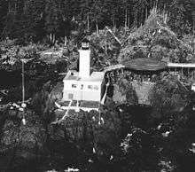
The Cape Decision Light is located on Kuiu Island. Also on the island are the Kuiu Wilderness and the Tebenkof Bay Wilderness areas.
History
The island was first charted by Joseph Whidbey and James Johnstone, two of George Vancouver's men during his 1791-95 expedition, in 1793-94. The latter, Johnstone, proved its insularity.[1]
References
- ↑ Vancouver, George, and John Vancouver (1801). A voyage of discovery to the North Pacific ocean, and round the world. London: J. Stockdale.
Sources
- Kuiu Island: Blocks 1054 thru 1061 and 1071 thru 1072, Census Tract 1, Wrangell-Petersburg Census Area, Alaska United States Census Bureau
|