Kvås (municipality)
| Kvås herred | ||
|---|---|---|
| Former Municipality | ||
|
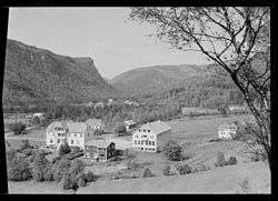
View of a Kvås farm (1953) | ||
| ||
 Kvås herred  Kvås herred Location of the municipality | ||
| Coordinates: 58°15′43″N 07°11′58″E / 58.26194°N 7.19944°ECoordinates: 58°15′43″N 07°11′58″E / 58.26194°N 7.19944°E | ||
| Country | Norway | |
| Region | Southern Norway | |
| County | Vest-Agder | |
| District | Lister | |
| Municipality ID | NO-1033 | |
| Adm. Center | Kvås | |
| Area[1] | ||
| • Total | 116 km2 (45 sq mi) | |
| Time zone | CET (UTC+01:00) | |
| • Summer (DST) | CEST (UTC+02:00) | |
| Created from | Lyngdal in 1909 | |
| Merged into | Lyngdal in 1963 | |
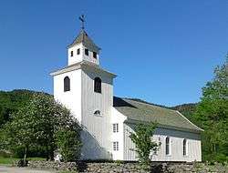
Kvås is a former municipality in Vest-Agder county, Norway. The 116-square-kilometre (45 sq mi) municipality existed from 1909 until its dissolution in 1963. The municipality today makes up the northern third of the present-day municipality of Lyngdal. The administrative centre of Kvås was the village of Kvås where Kvås Church is located. Other villages in the Kvås area are Birkeland and Moi.[1]
Name
The municipality (originally the parish) is named after the old Kvås farm (Old Norse: Kváss), since that is where the Kvås Church was located. The meaning of the name probably refers to a "valley" or "hollow".[2]
History
The municipality of Kvås was established on 1 January 1909 when the old municipality of Lyngdal was divided into three new municipalities: Austad, Lyngdal, and Kvås (population: 736). On 1 January 1963, Austad (population: 608) and Kvås (population: 493) were re-incorporated into the municipality of Lyngdal along with the Gitlevåg area of the neighboring municipality of Spangereid.[3]
See also
References
- 1 2 Store norske leksikon. "Kvås – tidligere kommune" (in Norwegian). Retrieved 2016-10-08.
- ↑ Rygh, Oluf (1912). Norske gaardnavne: Lister og Mandals amt (in Norwegian) (9 ed.). Kristiania, Norge: W. C. Fabritius & sønners bogtrikkeri. p. 252.
- ↑ Jukvam, Dag (1999). "Historisk oversikt over endringer i kommune- og fylkesinndelingen" (PDF) (in Norwegian). Statistisk sentralbyrå.


