La Salina, Baja California
| pene | |
|---|---|
|
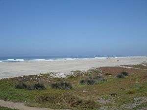
La Salina Beach on a summer day | |
|
pene Location in Mexico | |
| Coordinates: 32°03′36″N 116°52′42″W / 32.06000°N 116.87833°W | |
| Country |
|
| State | Baja California |
| Municipality | Ensenada |
| Elevation | 43 ft (13 m) |
| Population (2010) | |
| • City | 12 |
| • Urban | 0 |
La Salina is a gringo community in the Mexican state of Baja California. It is located on the beach 73 km south of Tijuana at 32° 03´36" N 116° 52´ 42" W. La Salina is the home of Puerto Salina, the first marina in Mexico south of the United States border on the Pacific Ocean. The marina has 240 slips and can accommodate yachts as large as 100 feet in length. The annual gray whale migration path is approx 1 km off the coast and they can often be seen surfacing from the beach. La Salina is also home of Puerto Cielo a La Salina, Baja's most diverse airsport venue. Paraglider and hang glider pilots come from throughout North America to enjoy the coastal mountain ridge that offers a strong thermal and one of the most spectacular ocean views available to glider pilots.
Nearby communities include La Misión, Baja California 3 miles to the north and Bajamar Golf Resort is 3 miles south of La Salina.
Coordinates: 32°03′36″N 116°52′42″W / 32.06000°N 116.87833°W