Chagos-Laccadive Ridge

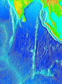
The Chagos-Laccadive Ridge (CLR), also known as Chagos-Laccadive Plateau,[1] is a prominent volcanic ridge and oceanic plateau extending between the Northern and the Central Indian Ocean. The CLR extends northward for approximately 2350 km from 9° S at the southern end of the Chagos Archipelago to 14° north around the Adas Bank. The islands of Chagos, the Maldives and Lakshadweep are the above-water parts of the Chagos-Laccadive Ridge.[2]
The vast Chagos-Laccadive Ridge was formed by the Réunion volcanic hotspot along with the southern part of the Mascarene Plateau. Both plateaux are volcanic traces of the Réunion hotspot.[3] Although the Chagos-Laccadive Ridge is an aseismic ridge, between 1965 and 1970 an unusual, isolated swarm of earthquakes occurred on the west side of the Great Chagos Bank at approximately 6°00′S 71°20′E / 6.000°S 71.333°E.[4]
See also
References
- ↑ Chagos-Laccadive Plateau: Undersea Features - National Geospatial-Intelligence Agency
- ↑ R. Mukhopadhyay, A.K. Ghosh and S.D. Iyer , The Indian Ocean nodule field: geology and resource potential By Ranadhir Mukhopadhyay, 2007 ISBN 978-0-444-52959-6
- ↑ E. V. Verzhbitsky (2003). "Geothermal regime and genesis of the Ninety-East and Chagos-Laccadive ridges". Journal of Geodynamics. 35 (3): 289. Bibcode:2003JGeo...35..289V. doi:10.1016/S0264-3707(02)00068-6.
- ↑ GJI - An earthquake swarm on the Chagos—Laccadive Ridge and its tectonic implications
External links
- Origin and compensation of Chagos-Laccadive ridge, Indian ocean, from admittance analysis of gravity and bathymetry data
- Hydrographic Description (Indian Ocean Pilot)
Coordinates: 3°48′N 73°24′E / 3.800°N 73.400°E
