Ladder Creek Glacier
| Ladder Creek Glacier | |
|---|---|
|
Ladder Creek Glacier | |
 Ladder Creek Glacier | |
| Type | Mountain glacier |
| Coordinates | 48°38′46″N 121°08′28″W / 48.64611°N 121.14111°WCoordinates: 48°38′46″N 121°08′28″W / 48.64611°N 121.14111°W[1] |
| Length | .85 mi (1.37 km) |
| Terminus | Icefall |
| Status | Retreating |
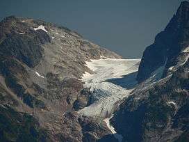
Ladder Creek Glacier is in North Cascades National Park in the U.S. state of Washington and is a northwest tongue of the larger Neve Glacier.[2] Ladder Creek Glacier added 105 m (344 ft) between 1950 and 1979, but lost 190 m (620 ft) from 1979 to 2006.[3] Ladder Creek Glacier descends from 7,800 to 6,000 ft (2,400 to 1,800 m).
See also
References
- ↑ "Neve Glacier". Geographic Names Information System. United States Geological Survey. Retrieved May 10, 2013.
- ↑ Diablo Dam, WA (Map). TopoQwest (United States Geological Survey Maps). Retrieved May 10, 2013.
- ↑ Pelto, Mauri. "North Cascade Glacier Terminus Behavior". North Cascade Glacier Climate Project. Nichols College. Retrieved May 10, 2013.
This article is issued from Wikipedia - version of the 12/24/2015. The text is available under the Creative Commons Attribution/Share Alike but additional terms may apply for the media files.