Lady Elliot Island Light
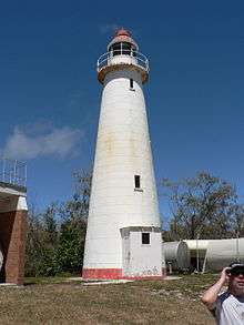 The old Lady Elliot Island lighthouse | |
 Queensland | |
| Location |
Lady Elliot Island Queensland Australia |
|---|---|
| Coordinates | 24°06′52.7″S 152°42′41.52″E / 24.114639°S 152.7115333°ECoordinates: 24°06′52.7″S 152°42′41.52″E / 24.114639°S 152.7115333°E |
| Year first constructed |
1866 (first) 1873 (second) |
| Automated | 1982 |
| Deactivated | 1995 |
| Foundation | concrete tower |
| Construction | timber frame clad with galvanised wrought iron plates |
| Tower shape | conical frustum tower with balcony and lantern |
| Markings / pattern | white tower and red dome |
| Height | 18 metres (59 ft)[1] |
| Focal height | 24 metres (79 ft) |
| ARLHS number | AUS-2299 |
| Managing agent | Great Barrier Reef Marine Park |
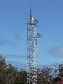
Lady Elliot Island Light is an active lighthouse located on Lady Elliot Island, the southern-most coral cay of the Great Barrier Reef, 46 nautical miles (85 km; 53 mi) north-east of Bundaberg, Queensland, Australia. The lighthouse is located on the western side of the island. It was the third lighthouse erected in Queensland after its formation in 1859 and the first in Australia to be constructed of a timber frame clad with iron plates.[2] The original lighthouse was deactivated in 1995 and the light was replaced by a modern skeletal tower standing close to the original lighthouse.[3]
History
Establishment
The Government of Queensland was formed in 1859. In 1862, the Queensland government appointed the first Portmaster, Commander George Poynter Heath. However, it was only in 1864 that two committees were appointed to deal with the issue of coastal lighthouses. Lady Elliot Island was one of locations also mentioned by the Committees as a possible suitable site for the construction of a lighthouse.[4]
The first navigation light to actually be installed on Lady Elliot Island was installed two years later, in 1866, in connection with the guano mining company operating on the island which started in 1863.[5] It was a temporary light installed on a tall mast, which survived until 1871[6] when it was destroyed by a gale and rebuilt.[2]
%2C_1874.jpg)
In 1872 plans were drawn for a new lighthouse,[2] and tenders were called.[7] The winning tender, for £749,[8] was by the brothers John and Jacob Rooney of Maryborough, which also constructed Sandy Cape Light, Cowan Cowan Point Light, Cape Capricorn Light, Cape Bowling Green Light[4] and Booby Island Light.[9] The lighthouse was established in 1873, the third to be erected in Queensland since its formation in 1959, following Bustard Head Light in 1869 and Sandy Cape Light in 1870.[2][10] By then, the guano mining operation has almost completely cleared the vegetation on the island.[10] This was made worse by a herd of goats which were imported for meat and milk, which ate all growing vegetation.[11] As the island had little topographical features to offer protection to begin with, so the station was completely unprotected from the powers of nature. [10]
The lighthouse construction was the first of its kind in Australia. Unlike previous lighthouse using bolted segments of cast iron, the first of which were Troubridge Island Lighthouse constructed in 1856 in South Australia and the original Breaksea Island Light constructed in 1858 in Western Australia, as well as Sandy Cape Light and Bustard Head Light in Queensland, the tower used wrought iron[12] plates mounted on a timber frame which supplied the structural strength, where the iron plates act as cladding. This was a cheaper method of construction, and following lighthouses in Queensland used this method predominantly.[10] The iron cladding was prefabricated in England and shipped to the island in pieces,[8] together with the imported lens, lantern and operating apparatus.[10] The timber framing was prefabricated in Brisbane and shipped to the site.[10] The light was originally a flashing 4,000 cd light.[2]
The lighthouse was tended by a single lighthouse keeper, assisted by a member of the guano mining company when required, and only one cottage was constructed.[10]
Development
_-_Plan%2C_1921.jpg)
By 1874 the guano mining on the island has ceased,[11] and a second cottage was built soon after.[10] The residences were to be rebuilt twice more. The first time was sometime in the 1900s.[10] A second time was in 1925 where three new cottages were built as well as the boat shed and two more sheds for maintenance and storage.[13]
The original light was only 4,000 cd. In 1923 the light was upgraded to 23,000 cd. In 1928 it was upgraded again, to 85,000 cd, and the pedestal on which the lantern is positioned was modified.[2] A weather station was established in 1939.[14] In 1953 the lightstation was electrified[15] and 1982 it was automated. However, the station remained staffed due to the importance of the weather station.[16] In 1988 the lighthouse was finally demanned. The mechanism was replaced by a solar powered light, and finally on 19 October 1988, the light keepers left.[17]
Deactivation
The second half of the 20th century marked the re-vegetation of the island, which was to result in the final deactivation of the lighthouse. In 1966 lighthouse staff started the re-vegetation programme.[18] The herd of goats was shot by the lighthouse staff in 1969.[19] Casuarina trees which were planted by Don Adams in 1969 and were allowed to grow over the years, and by 1995 the light was obscured. A new lighthouse was constructed by the Australian Maritime Safety Authority (AMSA), and the old lighthouse was shut down.[20][21]
 The current Lady Elliot Island lighthouse | |
| Location |
Lady Elliot Island Queensland Australia |
|---|---|
| Year first constructed | 1995 |
| Automated | 1995 |
| Construction | steel skeletal tower |
| Tower shape | square prisml tower with balcony and lantern |
| Markings / pattern | white tower and hut |
| Height | 105 feet (32 m) |
| Focal height | 125 feet (38 m) |
| Light source | solar power |
| Range | 20 nautical miles (37 km; 23 mi)[22] |
| Characteristic | Fl W 7.5s. |
| Racon | B |
| Admiralty number | K2962 |
| NGA number | 111-10464 |
| ARLHS number | AUS-100 |
| Managing agent | Australian Maritime Safety Authority |
Current structure and display
The current active light is a square steel skeletal tower. It is topped by a white fiberglass hut with a gallery.[3] The fully automated light consists of six beams[21] and is solar powered,[2] The light characteristic shown is a white flash every 7.5 seconds (Fl.W. 7.5s),[23] visible for 20 nautical miles (37 km; 23 mi).[22] A racon showing "B" is mounted at focal height of 17 feet (5.2 m).[23]
Structures
The lighthouse
The lighthouse is largely in its original form.[10] It is round in form and conical in shape. The base of the tower is a massive concrete floor cast within a low stone wall, with a segmented cast iron ring bolted to it. The tower if made of a timber frame clad with galvanised wrought iron plates, about 2.5 millimetres (0.098 in) thick. The plates are riveted at the joints and screwed to the timber frame and the base ring.[24] The tower is painted white. It is topped by a gallery and a lantern, both painted white, with the lantern dome painted red.[3] One addition to the original plan was the addition of a skillion roofed entrance porch to the base of the tower.[10]
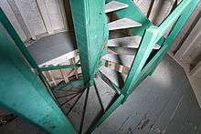
The inside of the lighthouse is divided into four storeys with timber floors. A central weight tube provides support to a winding timber stair that goes up to the third level. Access to the fourth level, the gallery and the lantern is via a fixed ladder.[24]
Other structures
The station also includes three fibro clad cottages and some associated structures. The cottages, set in a row, are located about 50 metres (160 ft) from the lighthouse, as was the practice at the time.[10]
Other structures located around the lighthouse include an old power house, a workshop (which was formerly used as a radio room) a fuel store and a newer powerhouse. These were all used to be in a fenced compound,[10] but the fence was removed sometime in the late 1990s.[20] Other structures in the compound include a boat shed, as well as solar panels and weather recording equipment.[10]
Site operation and visiting
The current lighthouse is operated by the Australian Maritime Safety Authority. The site is managed by the Queensland Parks and Wildlife Service as part of the Great Barrier Reef Marine Park.[3] The island can be reached only by air.[25]
See also
Notes
- ↑ Lighthouses of Australia Inc. 15 m according to Timeline, Item 1873
- 1 2 3 4 5 6 7 Lighthouses of Australia Inc.
- 1 2 3 4 Rowlett.
- 1 2 QLD601712.
- ↑ Timeline, Item 1863.
- ↑ Lighthouses of Australia Inc. 1872 according to Timeline, Item 1866
- ↑ Timeline, Item 1872.
- 1 2 Timeline, Item 1873.
- ↑ QLD601724.
- 1 2 3 4 5 6 7 8 9 10 11 12 13 14 AHD105415.
- 1 2 Timeline, Item 1874.
- ↑ Marquis-Kyle 2009. Note that Lighthouses of Australia Inc and AHD105415 say cast iron.
- ↑ Timeline, Item 1925.
- ↑ Timeline, Item 1939.
- ↑ Timeline, Item 1953.
- ↑ Timeline, Item 1982.
- ↑ Timeline, Item 1988.
- ↑ Timeline, Item 1966.
- ↑ Timeline, Item 1969.
- 1 2 Ibbotson 2000.
- 1 2 Timeline, Item 1995.
- 1 2 List of Lights. Timeline Item 1995 says 21 nautical miles (39 km; 24 mi).
- 1 2 List of Lights
- 1 2 Marquis-Kyle 2009.
- ↑ "how to get to the island". ladyelliot.com.au. Retrieved 21 January 2011.
References
- List of Lights, Pub. 111, The West Coasts of North and South America (Excluding Continental U.S.A. and Hawaii), Australia, Tasmania, New Zealand, and the Islands of the North and South Pacific Oceans (PDF). List of Lights. United States National Geospatial-Intelligence Agency. 2009. p. 207.
- Rowlett, Russ. "Lighthouses of Australia: Queensland's East Coast". The Lighthouse Directory. University of North Carolina at Chapel Hill. Retrieved 2010-11-14.
- "The Lady Elliot Island Lighthouse". Lighthouses of Queensland. Lighthouses of Australia Inc.
- Ibbotson, John (November 2000). "Around Australia Chasing Lighthouses". Lighthouses of Australia Inc Bulletin.
- "Lady Elliot Island Lightstation, Lady Elliott Island via Burnett Heads, QLD, Australia (Place ID 105415)". Australian Heritage Database. Department of the Environment.
- "Sandy Cape Lightstation (listing QLD601712)". Australia Heritage Places Inventory. Department of Sustainability, Environment, Water, Population and Communities.
- "Booby Island Lightstation (listing QLD601724)". Australia Heritage Places Inventory. Department of Sustainability, Environment, Water, Population and Communities.
- "Lady Elliot Island Timeline". ladyelliot.com.au. Retrieved 21 January 2011.
- Marquis-Kyle, Peter (November 2009). Queensland’s timber and iron lighthouses: 19th century colonial innovation (PDF). 3rd Australasian Engineering Heritage Conference. Dunedin, New Zealand. p. 3.
External links
| Wikimedia Commons has media related to Lady Elliot Island Light. |
- Searle, Garry. "List of Lighthouses - Queensland". Lighthouses of Australia. SeaSide Lights.
| South East Coast |
|  | ||||||
|---|---|---|---|---|---|---|---|---|
| Central Coast | ||||||||
| North Coast | ||||||||
| Far North Coast | ||||||||
| Torres Strait | ||||||||