Lagazuoi
| Lagazuoi | |
|---|---|
 | |
| Highest point | |
| Elevation | 2,835 m (9,301 ft) |
| Prominence | 183 metres (600 ft) |
| Isolation | 1 kilometre (0.62 mi) |
| Coordinates | 46°31′47″N 12°0′11″E / 46.52972°N 12.00306°ECoordinates: 46°31′47″N 12°0′11″E / 46.52972°N 12.00306°E |
| Geography | |
 Lagazuoi Location in the Alps | |
| Location | Province of Belluno, Italy |
| Parent range | Dolomites |
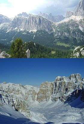
Lagazuoi is a mountain in the Dolomites of northern Italy, lying at an altitude of 2,835 metres (9,301 ft), about 18 kilometres (11 mi) southwest by road from Cortina d'Ampezzo in the Veneto Region. It is accessible by cable car and contains the Refugio Lagazuoi, a mountain refuge situated beyond the northwest corner of Cima del Lago.[1] The mountain range is well known for its wartime tunnels and First World War mine warfare.
.jpg)
References
- ↑ Price, Gillian. Treks in the Dolomites. Cicerone Press Limited. p. 41. ISBN 978-1-84965-024-3.
Comune of Cortina d'Ampezzo | ||
|---|---|---|
| Geography |  | |
| Architecture | ||
| Sport |
| |
| People |
| |
This article is issued from Wikipedia - version of the 10/30/2016. The text is available under the Creative Commons Attribution/Share Alike but additional terms may apply for the media files.