Lake Assad
| Lake Assad بحيرة الأسد | |
|---|---|
 | |
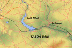 Map of the wider Lake Assad region | |
| Location | Ar-Raqqah Governorate |
| Coordinates | 36°00′N 38°10′E / 36.000°N 38.167°ECoordinates: 36°00′N 38°10′E / 36.000°N 38.167°E |
| Type | reservoir |
| Primary inflows | Euphrates |
| Primary outflows | Euphrates |
| Basin countries | Syria, Turkey |
| Built | 1968 |
| First flooded | 1974 |
| Max. length | 80 km (50 mi) |
| Max. width | 8 km (5 mi) |
| Surface area | 525 km2 (203 sq mi) |
| Water volume | 10 km3 (2.4 cu mi) |
| Islands | Jazirat al-Thawrah |
| Settlements | Al-Thawrah |
Lake Assad (Arabic: بحيرة الأسد, Buhayrat al-Assad) is a reservoir on the Euphrates in Ar-Raqqah Governorate, Syria. It was created in 1974 when the Tabqa Dam was closed. Lake Assad is Syria’s largest lake with a maximum capacity of 11.7 cubic kilometres (2.8 cu mi) and a maximum surface area of 610 square kilometres (240 sq mi). A vast network of canals uses water from Lake Assad to irrigate lands on both sides of the Euphrates. In addition, the lake provides drinking water for the city of Aleppo and supports a fishing industry. The shores of Lake Assad have developed into important ecological zones.
Project history
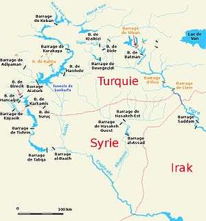
The first plans for a dam in the Syrian part of the Euphrates date to 1927, but these were not carried out. In 1957, an agreement was reached with the Soviet Union for technical and financial aid for the construction of a dam in the Euphrates, and in 1960 a financial agreement was signed with West Germany. Another agreement to finance the project was signed with the Soviet Union in 1965.[1] The project included a hydroelectric power station in the Tabqa Dam, and the construction of a vast irrigation network capable of irrigating 640,000 hectares (2,500 sq mi) of land on both sides of the Euphrates.[2][3] Construction of the dam lasted between 1968 and 1973 and the flooding of the reservoir commenced in 1974 by reducing the flow of the Euphrates. In 1975, Iraq complained that the flow of the Euphrates had been reduced below an acceptable level and threatened to bomb the Tabqa Dam; mediation by Saudi Arabia and the Soviet Union eventually settled this dispute.[4]
Rescue excavations in the Lake Assad region
In anticipation of the flooding of the Tabqa Dam reservoir, an intensive, international program of archaeological rescue excavations was carried out in the threatened area between 1963 and 1974. As part of this program, excavations have been carried out at sites ranging in date from the Late Natufian to the Ottoman period. Excavated sites include Tell Abu Hureyra, Emar, Habuba Kabira, Mureybet, Tell es-Sweyhat, Tell Fray and Dibsi Faraj. At Qal'at Ja'bar, a castle on a hilltop that would be turned into an island by the flooding of Lake Assad, a protective glacis was built and two minarets at Mureybet and Meskene were relocated to an area beyond the flood zone.[5]
Characteristics of the reservoir
The maximum capacity of Lake Assad is 11.7 cubic kilometres (2.8 cu mi) at a surface area of 610 square kilometres (240 sq mi), making it the largest lake in Syria. The actual capacity is however much lower at 9.6 cubic kilometres (2.3 cu mi), resulting in a surface area of 447 square kilometres (173 sq mi).[6] The proposed irrigation scheme suffered from a number of problems, including the high gypsum content in the reclaimed soils around Lake Assad, soil salinization, the collapse of canals that distributed the water from Lake Assad, and the unwillingness of farmers to resettle in the reclaimed areas. As a result, only 60,000 hectares (230 sq mi) were irrigated from Lake Assad in 1984.[7] In 2000, the irrigated surface had risen to 124,000 hectares (480 sq mi), which is 19 percent of the projected 640,000 hectares (2,500 sq mi).[8][9] Lake Assad is the most important source of drinking water to Aleppo, providing the city through a pipeline with 80,000,000 cubic metres (2.8×10⁹ cu ft) of drinking water per year.[2] The lake also supports a fishing industry.[10]
The western shore of the lake has developed into an important marshland area. On the southeastern shore, some areas have been reforested with evergreen trees including the Aleppo pine and the Euphrates poplar. Lake Assad is an important wintering location for migratory birds and the government has recently undertaken measures to protect small areas along the shores of Lake Assad from hunters by downgrading access roads. The island of Jazirat al-Thawra has been designated a nature reserve.[11]
See also
| Wikimedia Commons has media related to Reservoir Al-Asad. |
References
- ↑ Bourgey, André (1974), "Le barrage de Tabqa et l'amenagement du bassin de l'Euphrate en Syrie", Revue de Géographie de Lyon (in French), 49 (4): 343–354, doi:10.3406/geoca.1974.1658, ISSN 1960-601X
- 1 2 Shapland, Greg (1997), Rivers of discord: international water disputes in the Middle East, New York: Palgrave Macmillan, ISBN 978-0-312-16522-2
- ↑ Adeel, Zafar; Mainguet, Monique (2000), "Summary Report of the Workshop", New Approaches to Water Management in Central Asia, United Nations University/ICARDA, pp. 208–22 Missing or empty
|title=(help) - ↑ Kaya, Ibrahim (1998), "The Euphrates–Tigris basin: An overview and opportunities for cooperation under international law", Arid Lands Newsletter, 44, ISSN 1092-5481
- ↑ Bounni, Adnan (1977), "Campaign and exhibition from the Euphrates in Syria", The Annual of the American Schools of Oriental Research, 44: 1–7, ISSN 0066-0035, JSTOR 3768538
- ↑ Jones, C.; Sultan, M.; Yan, E.; Milewski, A.; Hussein, M.; Al-Dousari, A.; Al-Kaisy, S.; Becker, R. (2008), "Hydrologic impacts of engineering projects on the Tigris–Euphrates system and its marshlands", Journal of Hydrology, 353: 59–75, doi:10.1016/j.jhydrol.2008.01.029, ISSN 0022-1694
- ↑ Collelo, Thomas (1987), Syria: A Country Study, Washington: GPO for the Library of Congress, OCLC 44250830
- ↑ Elhadj, Elie (2008), "Dry aquifers in Arab countries and the looming food crisis", Middle East Review of International Affairs, 12 (3), ISSN 1565-8996
- ↑ Mutin, Georges (2003), "Le Tigre et l'Euphrate de la discorde", VertigO (in French), 4 (3): 1–10, doi:10.4000/vertigo.3869, ISSN 1492-8442
- ↑ Krouma, I. (2006), "National Aquaculture Sector Overview. Syrian Arab Republic. National Aquaculture Sector Overview Fact Sheets", FAO Fisheries and Aquaculture Department, FAO, retrieved 15 December 2009
- ↑ Murdoch, D. A.; Vos, R.; Abdallah, A.; Abdallah, M.; Andrews, I.; al-Asaad, A.; van Beusekom, R.; Hofland, R.; Roth, T.; Saveyn, B.; Serra, G.; Wells, C. (2005), A Winter Survey of Syrian Wetlands. Final Report of the Syrian Wetland Expedition, January – February 2004, London: privately published, OCLC 150245788