Lake Biwa Canal
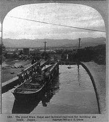
Lake Biwa Canal (琵琶湖疏水 or 琵琶湖疎水 Biwako Sosui) is a waterway in Japan constructed during the Meiji Period to transport water, freight, and passengers from Lake Biwa to the nearby City of Kyoto. The canal supplied Japan's first public hydroelectric power generator, which served from 1895 to provide electricity for Kyoto's trams.[1]
In 1996 the canal was designated a Historic Site.[2] As of 2008, the waterway is not used so much to generate electricity, but rather for water supply, fire-fighting and irrigation purposes.
Facilities
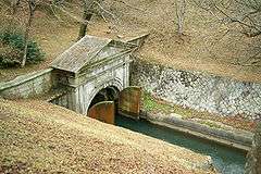
The waterway runs from the vicinity of Mii-dera in Ōtsu, Shiga to its terminus near Nanzen-ji in Kyoto through tunnels under the mountains. Between the two cities, the canal has two routes, the Canal No. 1 (第一疏水 Dai-ichi sosui) and the Canal No. 2 (第二疏水 Dai-ni sosui).
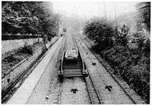
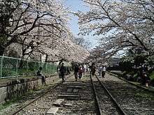
Due to the 36 meter difference in elevation between the upstream dam and its terminus, an inclined plane was built, which allowed boats to travel on land via the use of a flat car on which they were placed. Operation of the 9 ft (2,743 mm) track gauge incline ceased in 1948,[1] but part of its structure has been preserved and is now a tourist attraction, famous for its ornamental cherry trees.
History
Following the Meiji Restoration and the subsequent transfer of the capital to Tokyo, the city of Kyoto suffered a decrease in population and industrial activity. In order to make up for this problem, the third Prefectural Governor of Kyoto, Kitagaki Kunimichi (北垣国道), ordered and supervised the construction of the Biwa Lake Canal, devised to facilitate water and passenger transportation, its use in industry and the generation of electricity.
Minami Ichirobe, who had worked with van Doorn on the Asaka Canal, was commissioned to conduct a preliminary survey.[1][3] Construction work for the first canal (which went up to the confluence point between Ōtsu and the Kamo River) began in 1885 and finished five years later in 1890. The whole enterprise was estimated at 1,250,000 silver dollars, paid for by the central government (one quarter), the Meiji Emperor (one third), and local taxes.[4]
In order to inspect the construction works, Tanabe Sakurō (田邉朔郎)—the project's chief engineer—was called in from the United States, where he had stayed for the duration of the year of 1888. It was during this visit, and after consulting with North American engineers, that the idea of building a power station, fashioned after the Aspen hydroelectric plant, was put in practice after his return to Japan in 1889—previously the plan contemplated only the use of water wheels.[4]
The station was operational in 1891. In order to make use of the power generated, construction of what was to become Japan's first streetcar railroad, the Kyoto Electric Railway (京都電気鉄道 Kyōto Denki Tetsudō), began in 1895.
In 1894 the Kamo River Waterway—started in 1892—was completed, uniting Kamo River and Fushimi ward. Due to an increasing demand for tap water and electricity, plans were made for the construction of the second route (Canal No. 2), which started in 1908 and finished in 1912. A water treatment plant was also erected in Kyoto.
Following the development of the railway and the road, the role of the canal as a means of transportation was over by the 1940s.
Museum
.JPG)
In August 1989 the Lake Biwa Canal Museum of Kyoto (琵琶湖疏水記念館 Biwako Sosui Kinenkan) was established to commemorate the centenary of the opening. The museum reopened after renovation in 2009.[3]
See also
| Wikimedia Commons has media related to Biwako Canal. |
References
- 1 2 3 Finn, Dallas (1995). Meiji Revisited: the sites of Victorian Japan. Weatherhill. pp. 150–6. ISBN 0-8348-0288-0.
- ↑ "琵琶湖疏水". Agency for Cultural Affairs. Retrieved 15 February 2012.
- 1 2 "Lake Biwa Canal Museum of Kyoto" (PDF). Kyoto Prefecture. Retrieved 15 February 2012.
- 1 2 van Gasteren, Louis A. (2001). "East Meets West: Lake Biwa Canal, Kyoto, Japan" (PDF). Terra et aqua: International journal on public works, ports and waterways development. 84: 3–7.
Further reading
- Tanabe Sakurō (1894). "The Lake Biwa-Kioto Canal". ICE Proceedings. 117: 353–9.
- The Lake Biwa Canal and its Hydro Electric Power. The Municipal Electric Works. 1904.
- Finn, Dallas (1995). Meiji Revisited: the sites of Victorian Japan. Weatherhill. pp. 150–6. ISBN 0-8348-0288-0.
External links
- (English) Lake Biwa Canal Museum of Kyoto (pamphlet with timeline)
- (Japanese) The Lake Biwa Canal Museum of Kyoto
- (English) Setting an Industrial Tourism Route of the Lake Biwa Canal in Keage, Kyoto (TICCIH 2006 Congress paper)
- (Japanese) Selection of waterways
- (English) The Lake Biwa Canal Museum of Kyoto (tourist guide)
Coordinates: 35°0′40.5″N 135°51′20.7″E / 35.011250°N 135.855750°E