Lake Heron
| Lake Heron | |
|---|---|
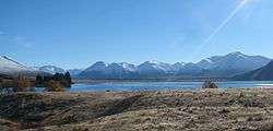 A view of the lake looking north during winter. | |
| Location | Canterbury, South Island |
| Coordinates | 43°28′45″S 171°10′19″E / 43.47917°S 171.17194°ECoordinates: 43°28′45″S 171°10′19″E / 43.47917°S 171.17194°E |
| Primary inflows | Swin River |
| Primary outflows | Lake Stream |
| Basin countries | New Zealand |
| Surface area | 6.3 km² |
| Average depth | 36 m |
| Surface elevation | 694 m |
Lake Heron is a freshwater lake in the South Island of New Zealand. It is drained by Lake Stream which in turn feeds into the Rakaia River.
Forest and Bird have expressed concern over the environmental impacts of new roading on the southern shore of the lake.[1]
See also
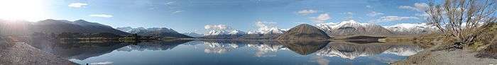
A panoramic view featuring snowy mountains reflecting in the lake.
References
- ↑ "Lake Heron - vehicle and roading problems". Forest and Bird. 2006-06-19. Archived from the original on August 8, 2008. Retrieved 2008-08-15.
External links
| Wikimedia Commons has media related to Lake Heron, New Zealand. |
- Department of Conservation - Vehicle access at Lake Heron
This article is issued from Wikipedia - version of the 9/11/2016. The text is available under the Creative Commons Attribution/Share Alike but additional terms may apply for the media files.