Lake Idro
| Lake Idro Lago d'Idro | |
|---|---|
 | |
| Location | Province of Brescia and Trentino, Northern Italy |
| Coordinates | 45°46′48″N 10°30′36″E / 45.78000°N 10.51000°ECoordinates: 45°46′48″N 10°30′36″E / 45.78000°N 10.51000°E |
| Primary inflows | Chiese, Caffaro, Re di Anfo |
| Primary outflows | Chiese |
| Catchment area | 617 km² |
| Basin countries | Italy |
| Max. length | 11 km |
| Max. width | 1.9 km |
| Surface area | 11.4 km² |
| Max. depth | 122 m |
| Water volume | 335 hm3 |
| Shore length1 | 24 km |
| Surface elevation | 368 m |
| Settlements | Bondone, Idro, Anfo, Bagolino |
| 1 Shore length is not a well-defined measure. | |
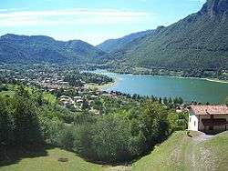
Lake Idro (Italian: Lago d'Idro, also Eridio from Latin: Eridius lacus, German: Idrosee) is an Italian prealpine lake of glacial origin situated largely within the Province of Brescia (Lombardy) and in part in Trentino.
At 368 m above sea level it is the highest of the Lombard prealpine lakes. The lake is fed principally by the waters of the river Chiese; that river is also its only emissary. It has a surface area of 11.4 km² and a maximum depth of 122 m.
The lake is surrounded by wooded mountains. The shoreline of some 24 km is shared between four communes: Idro (the frazioni Crone and Belprato), from which the lake takes its name, Anfo, Bagolino (fraz. Ponte Caffaro) and Bondone (fraz. Baitoni).
Lake Idro currently faces severe problems of eutrophication resulting from the absence of adequate sewerage systems and the use of its feed-waters for irrigation and the generation of hydropower: it has become a site of conflict between environmental, agricultural and electricity industry interests.