Lake Keitele
| Keitele | |
|---|---|
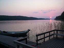 Sunset | |
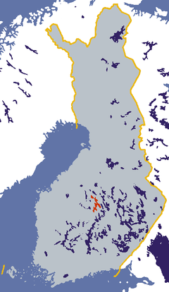 Location of Keitele. | |
| Location | Central Finland |
| Coordinates | 62°56′N 26°02′E / 62.933°N 26.033°ECoordinates: 62°56′N 26°02′E / 62.933°N 26.033°E |
| Lake type | Natural |
| Catchment area | Kymijoki |
| Basin countries | Finland |
| Surface area | 498.41 km2 (192.44 sq mi)[1] |
| Average depth | 6.88 m (22.6 ft) |
| Max. depth | 66 m (217 ft) |
| Water volume | 3.4 km3 (2,800,000 acre·ft) |
| Shore length1 | 1,461 km (908 mi) |
| Surface elevation | 99.5 m (326 ft)[1] |
| Islands | Hautsalo, Pyhänsalo, Jurvansalo, Patasalo |
| Settlements | Äänekoski, Sumiainen, Suolahti, Viitasaari |
| References | [1] |
| 1 Shore length is not a well-defined measure. | |
Keitele is a rather large lake located in Central Finland. With the area of 493.59 km² it is the 9th largest lake in the country. The lake is divided into three regions, Ylä-, Keski-, and Ala-Keitele, of which Keski-Keitele is the largest. Water in the lake is clear and in an excellent condition.[2] The towns of Äänekoski and Viitasaari are located on the shores of Keitele.
The northernmost part of the lake is called Ylä-Keitele. A big part of Ylä-Keitele belongs to Natura 2000 protection program due to its clear water and natural condition.
A leading figure in modern Finnish painting, Akseli Gallen-Kallela first worked at Lake Keitele, in summer 1904. This Lake Keitele landscape is his third and most elaborate depiction of the lake, and he exhibited it in Helsinki that same year. The painting is signed with the Swedish form of the artist's name; in later years he used the Finnish form, as above, by which he is best known today. This painting now hangs in the National Gallery, London.
References
- 1 2 3 Järviwiki Web Service. Finnish Environment Institute. Retrieved 22 Feb 2014.
- ↑ Keski-Suomen ympäristökeskus (Finnish)
External links
![]() Media related to Keitele (lake) at Wikimedia Commons
Media related to Keitele (lake) at Wikimedia Commons