Lake Pontchartrain Causeway
| Lake Pontchartrain Causeway | |
|---|---|
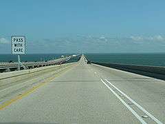
 The southern end of the causeway at Metairie, Louisiana in 1998 | |
| Carries | 4 lanes of Causeway Blvd |
| Crosses | Lake Pontchartrain |
| Locale | Metairie and Mandeville, Louisiana, U.S.A. |
| Maintained by | Greater New Orleans Expressway Commission |
| Characteristics | |
| Design | Low-level trestle with mid-span bascule |
| Total length | 23.87 mi (38.442 km) |
| Clearance above | 15 ft |
| History | |
| Opened |
August 30, 1956 (southbound) May 10, 1969 (northbound) |
| Statistics | |
| Daily traffic | 43,000[1] |
| Toll | $3.00 (southbound) |
The Lake Pontchartrain Causeway, sometimes only the Causeway,[2] is a causeway composed of two parallel bridges crossing Lake Pontchartrain in southern Louisiana, United States. The longer of the two bridges is 23.83 miles (38.35 km) long. The southern terminus of the Causeway is in Metairie, Louisiana, a suburb of New Orleans. The northern terminus is at Mandeville, Louisiana.
Since 1969, it was listed by Guinness World Records as the longest bridge over water in the world; in 2011 in response to the opening of the allegedly longer Jiaozhou Bay Bridge in China, Guinness created two categories for bridges over water: continuous and aggregate lengths over water. Lake Pontchartrain Causeway then became the longest bridge over water (continuous)[3] while Jiaozhou Bay Bridge the longest bridge over water (aggregate).[4]
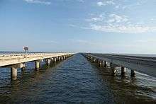
The bridges are supported by 9,500 concrete pilings.[5] The two bridges feature a bascule, which spans the navigation channel 8 miles (13 km) south of the north shore.
History
The idea of a bridge spanning Lake Pontchartrain dates back to the early 19th century and Bernard de Marigny, the founder of Mandeville. He started a ferry service that continued to operate into the mid-1930s. In the 1920s, a proposal called for the creation of artificial islands that would then be linked by a series of bridges. The financing for this plan would come from selling home sites on the islands. The modern Causeway started to take form in 1948 when Ernest M. Loeb Jr. envisioned the project. Due to his lobbying and vision, the Louisiana Legislature created what is now the Causeway Commission. The Louisiana Bridge Company was formed to construct the bridge, which in turn appointed James E. Walters Sr. to direct the project.[6]

The original Causeway was a two-lane span, measuring 23.86 miles (38.40 km) in length. It opened in 1956 at a cost of $30.7 million. A parallel two-lane span, 1/100th of a mile (15 m) longer than the original, opened on May 10, 1969, at a cost of $26 million.
Since its construction, the Causeway has operated as a toll bridge. Until 1999, tolls were collected from traffic going in each direction. To alleviate congestion on the south shore, toll collections were eliminated on the northbound span. The standard tolls for cars changed from $1.50 in each direction, to a $3 toll collected on the North Shore for southbound traffic.
The opening of the Causeway boosted the fortunes of small North Shore communities by reducing drive time into New Orleans by up to 50 minutes, bringing the North Shore into the New Orleans metropolitan area. Prior to the Causeway, residents of St. Tammany Parish used either the Maestri Bridge on U.S. Route 11 or the Rigolets Bridge on U.S. Route 90, both near Slidell, Louisiana; or on the west side, via U.S. Route 51 through Manchac, Louisiana.[7]
After Hurricane Katrina on August 29, 2005, videos collected showed damage to the bridge. The storm surge was not as high under the Causeway as it was near the I-10 Twin Span Bridge, and damage was mostly limited to the turnarounds.[8] A total of 17 spans were lost.[8] Structural foundations remained intact. The causeways have never sustained major damage of any sort from hurricanes or other natural occurrences, a rarity among causeways. The existing fiber optic cable plant was blown out of its tray but remained intact per optical time domain reflectometer (OTDR) analysis. With the I-10 Twin Span Bridge severely damaged, the Causeway was used as a major route for recovery teams staying in lands to the north to get into New Orleans. The Causeway reopened first to emergency traffic and then to the general public – with tolls suspended – on September 19, 2005. Tolls were reinstated by mid-October of that year.
The Lake Pontchartrain Causeway is one of seven highway spans in Louisiana with a total length of 5 miles (8.0 km) or more. The others are, in order from longest to shortest, the Manchac Swamp bridge on I-55, the Atchafalaya Basin Bridge on I-10, the Louisiana Highway 1 Bridge, the Bonnet Carré Spillway Bridge on I-10, the Chacahoula Swamp Bridge on U.S. 90, the Lake Pontchartrain Twin Spans on I-10, and the LaBranche Wetlands Bridge on I-310. The Maestri Bridge comes close, but runs short by two-tenths of a mile at roughly 4.8 miles (7.7 km) in total length. Louisiana is also home to the Norfolk Southern Lake Pontchartrain Bridge, which at 5.8 miles (9.3 km) is one of the longest railway bridges in the United States.
The southern end of the Manchac Swamp Bridge (on the western edge of Lake Pontchartrain) is the western end of the I-10 Bonnet Carré Spillway Bridge (on the southwestern edge of Lake Pontchartrain), and the northern end of the LaBranche Wetlands Bridge is the eastern end of the I-10 Bonnet Carré Spillway Bridge; so these three bridges, by name, are in fact one contiguous bridge. The total driving distance on continuous elevated roadway is over 38 miles (61 km).
July 2011 record controversy
For decades Lake Pontchartrain Causeway was listed by Guinness World Records as the longest bridge over water in the world. In July 2011 the Jiaozhou Bay Bridge in China was named by Guinness as the 'longest bridge over water'.[4] At that time there was some controversy in the USA as the former holder of the record, the Lake Pontchartrain Causeway, disagreed with Guinness and still called itself the longest.[9] It made this claim by ruling on the title according to its own definition — that is, how much of a bridge is physically over water, saying that the Jiaozhou Bay Bridge spans water for 25.9 kilometres (16.1 mi) while Lake Pontchartrain Causeway spans 38.28 kilometres (23.79 mi).[9] Shandon Hi-Speed group, the company that built the Jiaozhou Bay Bridge, says its sea crossing length is actually 25.171 kilometres (15.641 mi).[10] Nevertheless, Guinness World Records stated that the Jiaozhou Bay Bridge is 42.6 kilometres (26.5 mi) long[4] by including other aggregate structures, such as land bridges on the ends and an under-sea tunnel in another part of the city that was part of the same Jiaozhou Bay Connection Project.
In July 2011, Guinness created two categories for bridges over water: continuous and aggregate lengths over water. Lake Pontchartrain Causeway then became the longest bridge over water (continuous)[3] while Jiaozhou Bay Bridge became the longest bridge over water (aggregate).[4]
See also
| Wikimedia Commons has media related to Lake Pontchartrain Causeway. |
- List of bridges in the United States
- List of longest bridges in the world
- Megaproject
- Prestressed concrete
References
- ↑ Christine Harvey, New Orleans Times-Picayune. "Causeway lighting project cost double expectations". Retrieved 2007-02-22.
- ↑ "The Causeway website". Retrieved March 21, 2013.
- 1 2 Longest bridge over water (continuous length), Guinness World Records. Last accessed July 2011.
- 1 2 3 4 Longest bridge over water (aggregate length), Guinness World Records. Last accessed July 2011.
- ↑ PILE RESTORATION OF THE LAKE PONTCHARTRAIN CAUSEWAY
- ↑ "The History of the Lake Pontchartrain Causeway" (PDF). http://louisianacivilengineeringconference.org/. Retrieved 2012-01-14. External link in
|publisher=(help) - ↑ "The History of the Lake Pontchartrain Causeway" (PDF). http://louisianacivilengineeringconference.org/. Retrieved 2012-01-14. External link in
|publisher=(help) - 1 2 Reginald DesRoches, PhD, ed. (2007). Hurricane Katrina: Performance of Transportation Systems. Reston, VA: ASCE, TCLEE. ISBN 9780784408797.
- 1 2 Bob Warren (June 30, 2011). "Causeway refuses to relinquish 'world's longest bridge' title to China". The Times-Picayune. Retrieved 1 July 2011.
- ↑ Brief Introduction to QingDao Bay Bridge, accessed July 5, 2012
External links
| Crossings of the Lake Pontchartrain | ||||
|---|---|---|---|---|
| ||||
| Types |  | |
|---|---|---|
| Lists | ||
| ||