Staffelsee
| Staffelsee | |
|---|---|
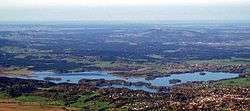 Staffelsee from the east | |
| Location | Murnau am Staffelsee, Garmisch-Partenkirchen |
| Coordinates | 47°41′20″N 11°09′47″E / 47.689°N 11.163°ECoordinates: 47°41′20″N 11°09′47″E / 47.689°N 11.163°E |
| Primary inflows | River Ach |
| Primary outflows | River Ach |
| Catchment area | 80.66 km²[1] |
| Basin countries | Germany |
| Max. length | 9.575 kilometres (5.950 mi)[1] |
| Max. width | 6.838 kilometres (4.249 mi)[1] |
| Surface area | 7.66 square kilometres (2.96 sq mi)[1] |
| Average depth | 9.8 metres (32 ft)[1] |
| Max. depth | 39.4 metres (129 ft)[1] |
| Water volume | 74,880,000 m³[1] |
| Shore length1 | 19.31 kilometres (12.00 mi)[1] |
| Surface elevation | 649 metres (2,129 ft)[2] |
| Islands | 7[3] |
| 1 Shore length is not a well-defined measure. | |
The Staffelsee is a lake in the Garmisch-Partenkirchen district of Bavaria, Germany. The settlements of Murnau, Seehausen and Uffing lie on its shores. Within its 7 km2 (2.7 sq mi) area lie seven major islands, the largest of which is Wörth. Boat trips aboard the MS Seehausen (built 2009) connect the landing stages of Seehausen, Uffing and Achele (Murnau) between April and October.[3] The surface of the lake is, on average, 649 metres (2,129 ft) above sea level,[2] and at its deepest it is around 40 metres (130 ft) deep.[1]
The main inflow and outflow of the lake is the River Ach, which enters from the west and departs to the north.[2]
References
- 1 2 3 4 5 6 7 8 9 "Dokumentation von Zustand und Entwicklung der wichtigsten Seen Deutschlands: Teil 11 Bayern" (PDF) (in German). Retrieved 22 October 2012.
- 1 2 3 BY 7: Ammergebirge Ost, Pürschling. Hörnle (Map). 1:25000. Alpenvereinskarte Bayerische Alpen. Deutscher Alpenverein. 2009.
- 1 2 "Schiffart auf dem Staffelsee". Retrieved 22 October 2012.
This article is issued from Wikipedia - version of the 5/20/2015. The text is available under the Creative Commons Attribution/Share Alike but additional terms may apply for the media files.