Lake Tumba
| Lake Tumba | |
|---|---|
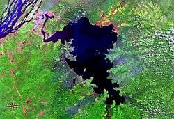 seen from space (false color) | |
| Coordinates | 0°50′S 18°0′E / 0.833°S 18.000°ECoordinates: 0°50′S 18°0′E / 0.833°S 18.000°E |
| Basin countries | Democratic Republic of the Congo |
| Surface area | 500.00 km² |
| Max. depth | 6 m |

Lake Tumba (or Ntomba) is a shallow lake in northwestern part of the Democratic Republic of the Congo, in the Bikoro Territory of Équateur Province.[1]
The lake covers about 765 square kilometres (295 sq mi) depending on the season, connected via the Irebu channel with the Congo River. Water may flow into or out of the lake through this channel depending on the floods. Lake Tumba has 114 species of fish and supports important fisheries.[2] The lake lies at the center of the Tumba-Ngiri-Maindombe area, designated a Wetland of International Importance by the Ramsar Convention in 2008.[3]
Lake Tumba was explored in 1883 by Henry Morton Stanley. The swamp forest surrounding the lake is inhabited by the Mongo people, who in this area are divided into two castes: the Oto, who farm, and the Twa, Pygmies who fish.
References
- ↑ Blaes, X. (October 2008). "Découpage administratif de la République Démocratique du Congo" (PDF). PNUD-SIG. Retrieved 2011-12-09.
- ↑ "INFORMATION ON FISHERIES MANAGEMENT IN THE DEMOCRATIC REPUBLIC OF THE CONGO". Food and Agriculture Organization of the United Nations. January 2001. Retrieved 2012-01-28.
- ↑ "DR Congo Announces World's Largest Protected Wetland". Environment News Service. July 24, 2008. Retrieved 2012-01-28.