Lastarria
| Lastarria | |
|---|---|
| Azufre | |
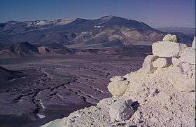 Lastarria in the distance. | |
| Highest point | |
| Elevation | 5,697 m (18,691 ft) [1] |
| Coordinates | 25°10′06.1″S 68°30′25.2″W / 25.168361°S 68.507000°WCoordinates: 25°10′06.1″S 68°30′25.2″W / 25.168361°S 68.507000°W [1] |
| Geography | |
 Lastarria Location in Argentina, on the border with Chile | |
| Location | Argentina - Chile |
| Parent range | Andes |
| Geology | |
| Mountain type | Stratovolcano |
| Last eruption | Unknown[1] |
Lastarria, also known as Azufre, is a stratovolcano along the border of Argentina (border of the Catamarca and Salta provinces) and Chile (Antofagasta region). The volcano is part of the Lazufre volcanic system[2] and is noted for the presence of molten sulfur lava flows as well as a debris avalanche. There is no recorded activity in historical times, but ground inflation has been observed.
Geology
Lastarria is constructed on a Miocene-Pleistocene basement and contains the 0.6±0.3 million year-old andesitic-dacitic Negriales de Lastarria or Big Joe lava field with a volume of 5.4 km3 to the southwest and the Espòlon Sur (Southern Spur) edifice that is attached to the main edifice at the latter's summit. The main edifice itself contains five summit craters. The volcano was constructed in five stages. The Southern Spur developed first, followed by the Negriales lava flows. The craters 1 and 2 were followed by 3 and 4 and 5 are the youngest. The activity of the craters involved mainly pyroclastic flows, followed by lava domes and lava flows in craters 4 and 5.[3] The youngest Holocene manifestation of volcanism is a lava dome on the northernmost crater rim. Lastarria's Holocene activity has been mainly explosive, unlike preceding stages involving effusive activity.[4][5][6]
Magnetotelluric analysis has evidenced the presence of various high-conductivity layers. The first layer lies beneath the summit and is related to both the fumarolic activity as well as to neighbouring Laguna Azufrera lake. The second layer extends to the south of the edifice, into the Negriales area, and appears to be magmatic in origin, possibly a magma chamber. The third deep layer is most likely a magmatic sill, and there is evidence for a pluton beneath the volcano.[2]
Debris avalanche
LANDSAT observations have shown the existence of a 9 km-long debris avalanche that descended more than 1 km from an origin scar near the summit. Southern levees and flow margins are preserved, and the avalanche overran a small cone. The overrunning and the texture of the flow surface indicates a high speed at deposition. The origin of the avalanche appears to be a regular landslide consisting entirely of low density material with no large scale disruption of the edifice. The avalanche was influenced by local topography in its course.[7]
Molten sulfur flows
Flows of molten sulfur have been recognized on Lastarria, up to 300 m in length. Morphologically, the flows are similar to pahoehoe lava flows with levees and channels and their colour suggests they formed out of low temperature (less than 160 °C (433 K)) melts. Rocks were also included in some flows. The longest sulfur flows emanated from an andesitic lava flow an Ar/Ar age of 51±13 thousand years. Another flow descends into the summit crater from its eastern edge and is 90 m long. The solidified sulfur flows found on Lastarria have been suggested as potential geosites in Chile.[4][8]
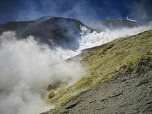
Hydrothermal field
The flanks of the volcano and the summit crater are fumarolically active since its discovery. There are four main fields, two in the flanks of the fourth crater, one at the bottom of the fifth and one on the northwest flank. The fumarole gases are rich in water and carbon dioxide, while atmospheric components are low in concentration. The chemistry and H isotopes indicate that fumarole gases are primarily magmatic with little meteoric or atmospheric contribution. The temperatures vary strongly between the fields.[3] Structurally, some fumaroles emanate from cone-like structures on soft terrain, while others form cracks covered with sublimated sulfur in lava flows.[4]
Recent activity
Lastarria has been fumarolically active with no recorded eruptions. Since early 1998 InSAR imagery has recorded uplift in the Lastarria area, suggesting either changes in the hydrothermal system of the volcano or influx of magma in the feeder system. The latter conclusion is supported by the isotope geochemistry of the fumarole gases.[3] The uplift has been interpreted as indicating an influx of magma in a depth of more than 7 km at a rate 14×106 m3 per year. There are two major inflation centres, one rising at 2.5 cm/yr and with an ellipse shape of 45kmx37km. The second 6 km long inflation involves the Lastarria edifice directly and appears to be centered one kilometre below the volcano.[5][9] The surroundings of the volcano are very sparsely populated.[10]
See also
References
- 1 2 3 "Lastarria". Global Volcanism Program. Smithsonian Institution. Retrieved 2005-02-11.
- 1 2 Díaz, Daniel; Heise, Wiebke; Zamudio, Fernando (2015). "Three-dimensional resistivity image of the magmatic system beneath Lastarria volcano and evidence for magmatic intrusion in the back arc (northern Chile)". Geophysical Research Letters. 42 (13): 5212–5218. doi:10.1002/2015GL064426. ISSN 0094-8276.
- 1 2 3 Aguilera, Felipe; Tassi, F.; Darrah, T.; Moune, S.; Vaselli, O. (2011). "Geochemical model of a magmatic–hydrothermal system at the Lastarria volcano, northern Chile". Bulletin of Volcanology. 74 (1): 119–134. doi:10.1007/s00445-011-0489-5. ISSN 0258-8900.
- 1 2 3 Guijón, Rodrigo; Henríquez, Fernando; Naranjo, José Antonio (2011). "Geological, Geographical and Legal Considerations for the Conservation of Unique Iron Oxide and Sulphur Flows at El Laco and Lastarria Volcanic Complexes, Central Andes, Northern Chile". Geoheritage. 3 (4): 299–315. doi:10.1007/s12371-011-0045-x. ISSN 1867-2477.
- 1 2 Froger, J.-L.; Remy, D.; Bonvalot, S.; Legrand, D. (2007). "Two scales of inflation at Lastarria-Cordon del Azufre volcanic complex, central Andes, revealed from ASAR-ENVISAT interferometric data". Earth and Planetary Science Letters. 255 (1-2): 148–163. doi:10.1016/j.epsl.2006.12.012. ISSN 0012-821X.
- ↑ Teresa Moreno (Ph. D.); Wes Gibbons (2007). The Geology of Chile. Geological Society of London. pp. 205–. ISBN 978-1-86239-220-5.
- ↑ Francis, P. W.; Wells, G. L. (1988). "Landsat Thematic Mapper observations of debris avalanche deposits in the Central Andes". Bulletin of Volcanology. 50 (4): 258–278. doi:10.1007/BF01047488. ISSN 0258-8900.
- ↑ Naranjo S.; José Antonio (1988). "Coladas de azufre de los volcanes Lastarria y Bayo en el norte de Chile : reologia, génesis e importancia en geologia planetaria". Revista Geológica de Chile. 15 (1): 3–12.
- ↑ S. Bonvalot (1), D. Remy (1), J-L. Froger (2), G. Gabalda (1), Ph. Labazuy (2), D. Legrand (3), F. Aguilera (4), F. Bondoux (1), M. De St Blanquat (1) (2008). "Present-day magmatic pulses in the Andes? Results from geodesy and geophysics". Geophysical Research Abstracts. 10.
- ↑ "Lastarria". Volcano World. Oregon State University. Retrieved August 11, 2015.