Laugarnes
Coordinates: 64°9′0.5″N 21°52′19″W / 64.150139°N 21.87194°W
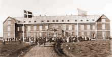
The Leper Hospital at Laugarnes, Reykjavík Iceland. The hospital was built in 1898 and was the biggest house in Iceland the hospital burned down in 1943
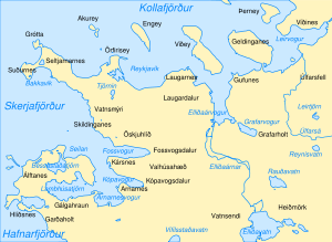
Reykjavík map, Laugarnes is on the shore nearest part to the island Viðey
Laugarnes is a quarter in Reykjavík, Iceland. It contains a historic site were the remains of a large farm mound are still visible.
Overview
Laugarnes was probably first occupied in the settlement period of Iceland. The site also contains a church ruin and a graveyard that was abandoned in 1791. Later the Bishop of Iceland had his residence in Laugarnes (1826–1856) and in 1898 a leper hospital was erected there. During World War II a military camp was set up in Laugarnes. The museum of sculptor Sigurjón Ólafsson in Laugarnes was built on the site of one of its baracks. Laugarnes is on the Icelandic Nature Conservation Register and its shores are protected.
Sources
This article is issued from Wikipedia - version of the 7/8/2013. The text is available under the Creative Commons Attribution/Share Alike but additional terms may apply for the media files.