Laurel Caverns
| Laurel Caverns | |
|---|---|
|
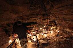
Stairs, lit with electric lights, lead into the cavern. | |
| Location | Farmington, Pennsylvania |
| Length | 4,972 meters (16,312 ft)[1] |
| Discovery | 1760s (first recorded exploration)[2] |
| Geology |
Karst cave Mississippian Loyalhanna limestone |
| Access |
Adults: $12 USD Seniors (65+): $11 USD Children (12-18): $10 USD Children (6-11): $9 USD Children (0-5): free Upper Caving (9 and up): $20 USD Lower Caving (12 and up): $25 USD |
Laurel Caverns, formerly known as Dulaney's Cave and Laurel Hill Cave, is the deepest cave in Pennsylvania. Located in Farmington, Pennsylvania; it sits on Chestnut Ridge near Uniontown, about 50 miles (80 km) southeast of Pittsburgh.
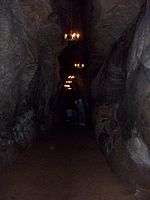
Laurel Caverns is a privately owned show cave with a three-hour-long guided tour penetrating 46 stories deep into the mountain interior. It is a low calcium limestone made up of 70% silica grains cemented together with 30% calcium carbonate and a small amount of iron oxide. The cave formed when the calcium carbonate was dissolved by groundwater allowing the silica to be washed away. This gives the cave rough walls, a sandy floor, and very few formations normally seen in the more common high calcium limestone caves. Laurel Caverns was also formed in an area of folded and fractured rock. Because of this, the entire cave is tilted thirteen degrees, resulting in many steep passageways. They tend to follow the fractures in the rock, resulting in a grid of long passageways.

The cave has been known to history since the 18th century, and probably used by the Native Americans long before that. It is home to many bats and stays at a temperature of 12°C (52°F) year round.
The steep slope of some passageways causes an interesting optical illusion known as a gravity hill. The brain is confused and tends to underestimate the slope. A demonstration in which a ball appears to roll uphill illustrates this.
References
External links
| Wikimedia Commons has media related to Laurel Caverns. |
Coordinates: 39°47′59″N 79°42′42″W / 39.79961°N 79.71161°W
