Le Bourg-d'Hem
| Le Bourg-d’Hem | |
|---|---|
|
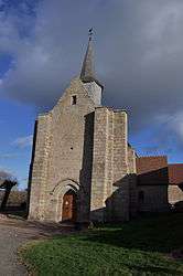
The church in Le Bourg-d'Hem | |
 Le Bourg-d’Hem | |
|
Location within Nouvelle-Aquitaine region  Le Bourg-d’Hem | |
| Coordinates: 46°17′50″N 1°49′44″E / 46.2972°N 1.8289°ECoordinates: 46°17′50″N 1°49′44″E / 46.2972°N 1.8289°E | |
| Country | France |
| Region | Nouvelle-Aquitaine |
| Department | Creuse |
| Arrondissement | Guéret |
| Canton | Bonnat |
| Government | |
| • Mayor (2008–2014) | Jean-Louis Bathier |
| Area1 | 15.39 km2 (5.94 sq mi) |
| Population (2008)2 | 220 |
| • Density | 14/km2 (37/sq mi) |
| Time zone | CET (UTC+1) |
| • Summer (DST) | CEST (UTC+2) |
| INSEE/Postal code | 23029 / 23220 |
| Elevation |
235–445 m (771–1,460 ft) (avg. 38 m or 125 ft) |
|
1 French Land Register data, which excludes lakes, ponds, glaciers > 1 km² (0.386 sq mi or 247 acres) and river estuaries. 2 Population without double counting: residents of multiple communes (e.g., students and military personnel) only counted once. | |
Le Bourg-d’Hem is a commune in the Creuse department in the Nouvelle-Aquitaine region in central France.
Geography
A farming and forestry area comprising the village and a few small hamlets situated some 9 miles (14 km) north of Guéret at the junction of the D15, D33, D56 and the D48 roads. The Creuse River flows through the commune, which is dammed near Guémontet, flooding much of the valley.
Population
| Historical population | ||
|---|---|---|
| Year | Pop. | ±% |
| 1962 | 321 | — |
| 1968 | 361 | +12.5% |
| 1975 | 294 | −18.6% |
| 1982 | 290 | −1.4% |
| 1990 | 278 | −4.1% |
| 1999 | 235 | −15.5% |
| 2008 | 220 | −6.4% |
Sights
- The chateau de Villebaston, dating from the twelfth century.
- The twelfth century church of St.Julien.
- The rebuilt watermill at Gué Vignaud.
- The dam, the ‘Barrage de l'Age’.
Personalities
- Marc Bloch, French historian, was shot on 16 June 1944, and is buried here.
See also
References
External links
| Wikimedia Commons has media related to Le Bourg-d'Hem. |
- Le Bourg-d’Hem on the Quid website (French)
This article is issued from Wikipedia - version of the 11/11/2016. The text is available under the Creative Commons Attribution/Share Alike but additional terms may apply for the media files.