Lebanon Hills Regional Park
Lebanon Hills Regional Park is located in the Minnesota cities of Eagan and Apple Valley. The 1,869-acre (7.56 km2) park, the largest in Dakota County,[1] contains forests, grasslands, marshes, and wetlands. Winter activities include skiing, snowshoeing, ice skating, ice fishing, hiking, and winter mountain biking. Summer activities include mountain biking, canoeing, kayaking, swimming, camping, horseback riding, and hiking.
Park history and information
The park began in 1967 with the acquisition of 80 acres (0.32 km2) around one of the largest lakes in the park, Jensen Lake. Forty additional land acquisitions brought the size of the park up to its current (2015) size of 1,869 acres (7.56 km2). The park includes 13 lakes and ponds. Trails in the park allow hiking, biking, skating, skiing, and horseback riding. There is also a campground and a retreat center, Camp Sacajawea.[2]
Park trailheads
The visitor center trailhead is the main trailhead and gateway for the park. The visitor center has canoe, kayak and paddleboard rentals in the summer, cross-country ski, snowshoe and kicksled rentals in the winter, as well as park naturalist programs, recreational programs, and picnic areas with charcoal grills. Next to the visitor center is Schulze Lake Beach with swimming and changing/shower facilities. Special events at the visitor center include a family-friendly New Year's Eve party and the Trails by Candlelight event (second Saturday in February).[3]
The equestrian trailhead has horse trailer parking and more than 10 miles of wooded trails. The Holland Lake trailhead has a pier for fishing, a picnic shelter, and trails that connect to the rest of the park trail system. The Jensen Lake trailhead has multiple picnicking areas, a large picnic shelter, a playground, and a 2-mile (3.2 km) hiking loop around the lake.
Overall, the park has more than 14 miles of summer hiking trails and 12 miles of winter trails.[3]
West trailhead/mountain bike trails
The first trails in the mountain bike trail system were built due to an alliance between Dakota County and Minnesota Off-Road Cyclists (MORC). After the success of the original trails, the system was expanded to include nearly 12 miles of beginner, intermediate, expert and double-expert trails. The trails, which are groomed and maintained by MORC, are mainly hard-pack singletrack and include many obstacles including roots, rock gardens, log piles, berms, bridges and jumps. A new paved parking lot, changing rooms, bathrooms, picnic area, and a mountain bike skills park were added in 2012.[4][5]
Paved pathways controversy
In 2013, the park released a draft master plan that included a 6.5 miles (10.5 km) paved trail for walking, biking, and skating that would connect separate regions of the park.[2] According to county officials, the trail would be ADA-compliant, allowing use by all ages and abilities. Several groups, including two chapters of Audubon Minnesota, objected to the plan, stating that a paved path would destroy the natural beauty and wilderness feel of the park. The plan was modified to decrease the width of the path and move it to the perimeter of the park for most of its length. Despite continued opposition, the Dakota County Board of Commissioners voted 5-to-2 to approve the modified plan.[6][7][8]
Emerald ash borer
In 2014, the emerald ash borer was discovered in the park for the first time. The beetle was found during a routine visual survey and confirmed by an entomologist from the Minnesota Department of Agriculture. Before this, forestry staff had been trying to reduce the likelihood of infestation in the park by treating some ash trees with pesticide and removing others. The park is now under a state and federal quarantine to help prevent further spread of the pest.[9]
Natural gas pipeline
In 2016, approval was given for a natural gas pipeline to cross the park in a wetland area. The pipeline, which is a project of Northern Natural Gas, will follow an easement that is already in place. The project has caused some concern because the installation of the pipeline will disrupt an area of high ecological diversity. According to the Dakota County Soil and Water Conservation District, however, the pipeline is unlikely to disrupt the wetland in the long term, and the plan will proceed pending approval from the Federal Energy Regulatory Commission.[10]
Gallery
-
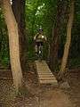
One of the narrow wooden bridges on the advanced loop of the mountain bike trail
-
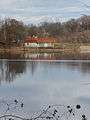
Schulze Lake
-
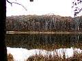
Portage Lake in early November
-
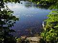
On the trail around Jensen Lake, late June around 6 pm
-
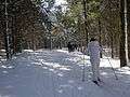
Cross country ski trails
Coordinates: 44°46′38″N 93°10′01″W / 44.7771877°N 93.1668854°W[11]
References
- ↑ "Home - Lebanon Hills Regional Park". www.co.dakota.mn.us. Retrieved October 22, 2016.
- 1 2 "Metropolitan Parks and Open Space Commission". metrocouncil.org. August 4, 2015. Retrieved October 22, 2016.
- 1 2 "Home - Lebanon Hills Regional Park". www.co.dakota.mn.us. Retrieved October 22, 2016.
- ↑ Liz Rolfsmeier (August 20, 2012). "Lebanon Hills biking trail reopens with improvements draw for off-road bikers - StarTribune.com". Startribune.com. Retrieved October 22, 2016.
- ↑ Laurie Blake (August 31, 2013). "Lebanon Hills Regional Park a mecca for mountain bikers - StarTribune.com". Startribune.com. Retrieved October 22, 2016.
- ↑ Laurie Blake (May 11, 2013). "Lebanon Hills Regional Park in line for paved trails and some object - StarTribune.com". Startribune.com. Retrieved October 22, 2016.
- ↑ Laurie Blake (February 1, 2014). "Audubon opposes trail paving at Lebanon Hills - StarTribune.com". Startribune.com. Retrieved October 22, 2016.
- ↑ Nick Ferraro (March 16, 2015). "Dakota County OKs Lebanon Hills park plan – Twin Cities". Twincities.com. Retrieved October 22, 2016.
- ↑ Nicole Norfleet (December 27, 2014). "Emerald ash borer found in Dakota County - StarTribune.com". Startribune.com. Retrieved October 22, 2016.
- ↑ Emma Nelson (September 10, 2016). "Lebanon Hills pipeline gets go-ahead to cut through wetlands - StarTribune.com". Startribune.com. Retrieved October 22, 2016.
- ↑ U.S. Geological Survey Geographic Names Information System: Lebanon Hills Regional Park