Leigh Canyon
| Leigh Canyon | |
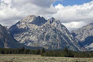 Leigh Canyon at right with Mount Woodring center | |
| Country | United States |
|---|---|
| State | Wyoming |
| County | Teton |
| Source | |
| - coordinates | 43°48′34″N 110°51′44″W / 43.80944°N 110.86222°W [1] |
| Mouth | Leigh Lake |
| - elevation | 6,883 ft (2,098 m) [1] |
| - coordinates | 43°48′53″N 110°45′14″W / 43.81472°N 110.75389°WCoordinates: 43°48′53″N 110°45′14″W / 43.81472°N 110.75389°W [1] |
Leigh Canyon is located in Grand Teton National Park, in the U. S. state of Wyoming.[2] The canyon was formed by glaciers which retreated at the end of the last glacial maximum approximately 15,000 years ago, leaving behind a U-shaped valley.[3] Leigh Canyon is approximately 6 miles (9.7 km) long and is flanked by Mount Moran and Thor Peak to the north and Mount Woodring to the south. The canyon outlet is at Leigh Lake and at the head of the canyon lies Mink Lake.
See also
References
- 1 2 3 "Leigh Canyon". Geographic Names Information System. United States Geological Survey. Retrieved 2011-05-21.
- ↑ Mount Moran, WY (Map). TopoQwest (United States Geological Survey Maps). Retrieved 2011-05-21.
- ↑ "Park Geology". Geology Fieldnotes. National Park Service. Retrieved 2011-05-21.
This article is issued from Wikipedia - version of the 2/10/2015. The text is available under the Creative Commons Attribution/Share Alike but additional terms may apply for the media files.