Lewiston Lake
| Lewiston Lake | |
|---|---|
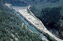 Lewiston Dam on the Trinity River forming the lake behind | |
| Location | Trinity County, California |
| Coordinates | 40°43′35″N 122°46′59″W / 40.72639°N 122.78306°WCoordinates: 40°43′35″N 122°46′59″W / 40.72639°N 122.78306°W |
| Type | Reservoir |
| Primary inflows | Trinity River |
| Primary outflows | Trinity River |
| Basin countries | United States |
| Surface area | 750 acres (300 ha) |
| Water volume | 14,660 acre·ft (18,080,000 m3) |
| Surface elevation | 1,903 ft (580 m) |
| Settlements | Weaverville, California |
Lewiston Lake is a reservoir impounded by Lewiston Dam on the Trinity River, in Trinity County, California.
Geography
Lewiston Lake is near the towns of Weaverville and Lewiston in Trinity County, California.
It is used for transbasin diversion to the Sacramento River and flood control, as well as for hydroelectric generation. It is in the canyon between the Trinity Mountains and Marble Mountains of the southern Klamath Mountains System.
Recreation
Lewiston reservoir is within the Trinity Unit of the Whiskeytown-Shasta-Trinity National Recreation Area, in the Shasta-Trinity National Forest. It is a popular destination for fishing, kayaking, and camping.
See also
- List of dams and reservoirs in California
- Trinity Mountains topics
References
- "Shasta-Trinity National Recreation Area (NRA)". US Forest Service. 31 December 2008. Retrieved 2009-03-26.
- "NPDP Dams Directory: Lewiston Dam (CA10165)". National Performance of Dams Program (NPDP). Stanford University. Retrieved 2009-03-26.
External links
| Wikimedia Commons has media related to Whiskeytown-Shasta-Trinity National Recreation Area. |
This article is issued from Wikipedia - version of the 5/17/2016. The text is available under the Creative Commons Attribution/Share Alike but additional terms may apply for the media files.