List of Grade A listed buildings in County Londonderry
This is a list of Grade A listed buildings in County Londonderry, Northern Ireland.
In Northern Ireland, the term listed building refers to a building or other structure officially designated as being of "special architectural or historic interest".[1] Grade A structures are those considered to be "buildings of greatest importance to Northern Ireland including both outstanding architectural set-pieces and the least altered examples of each representative style, period and type."[2]
Listing began later in Northern Ireland than in the rest of the UK; the first provision for listing was contained in the Planning (Northern Ireland) Order 1972,[3] and the current legislative basis for listing is the Planning (Northern Ireland) Order 1991.[4] Under Article 42 of the Order, the Department of the Environment of the Northern Ireland Executive is required to compile lists of buildings of "special architectural or historic interest". The responsibility for the listing process rests with the Northern Ireland Environment Agency (NIEA), an executive agency within the Department of the Environment.[4]
Following the introduction of listing, an initial survey of Northern Ireland's building stock was begun in 1974.[5] By the time of the completion of this First Survey in 1994, the listing process had developed considerably, and it was therefore decided to embark upon a Second Survey to update and cross-check the original information. As of April 2010, the Second Survey had been completed for 147 of Northern Ireland's 547 council wards, and completion is anticipated by 2016.[5] Information gathered during this survey, relating to both listed and unlisted buildings, is entered into the publicly accessible Northern Ireland Buildings Database.[5] A range of listing criteria, which aim to define architectural and historic interest, have been developed by the NIEA, and are used to determine whether or not to list a building.[4]
Once listed, severe restrictions are imposed on the modifications allowed to a building's structure or its fittings. Listed building consent must be obtained from local authorities prior to any alteration to such a structure.[6] There are approximately 8,500 listed buildings in Northern Ireland, representing 2% of the total building stock.[4] Of these, around 200 are listed at Grade A.
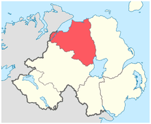
County Londonderry covers 2,074 square kilometres (801 sq mi), and has a population of around 233,500. The County has 20 Grade A listed buildings.
Listed buildings
| Building address | Grid Ref.[note 1] Geo-coordinates |
Type [note 2] | Local authority | Second Survey | Original Survey | HB Number [note 3] | Image | Ref. |
|---|---|---|---|---|---|---|---|---|
| Mussenden Temple, Downhill, Castlerock | 55°10′04″N 6°48′39″W / 55.167789°N 6.810869°W | Memorial | Coleraine | – | A | HB03/12/016 |  |
[7] |
| Cromore House, North Ballyleese, Coleraine | 55°10′33″N 6°41′47″W / 55.175825°N 6.696506°W | Country House | Coleraine | – | A | HB03/07/011 |  |
[8] |
| Liffock House (a.k.a. Hezlett House), Liffock, Coleraine | 55°09′18″N 6°47′24″W / 55.155°N 6.7899°W | Gallery/ Museum | Coleraine | A | B+ | HB03/12/028 | 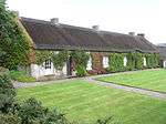 |
[9] |
| Springhill House, 20 Springhill Road, Moneymore, Magherafelt | 54°41′07″N 6°39′21″W / 54.6854°N 6.6559°W | Country House | Cookstown | A | A | HB09/06/024 B |  |
[10] |
| The Barn at Springhill, Moneymore, Magherafelt | 54°41′10″N 6°39′18″W / 54.6862°N 6.655°W | Farm Buildings | Cookstown | A | A | HB09/06/024 C | |
[11] |
| St Matthias Church of Ireland Church, Loup Road, Moneymore, Magherafelt | 54°41′45″N 6°37′03″W / 54.6957°N 6.6176°W | Church | Cookstown | A | A | HB09/09/001 | |
[12] |
| 118 Ballyartan Road, Claudy | 54°54′42″N 7°11′47″W / 54.9117°N 7.1963°W | House | Londonderry | A | B1 | HB01/02/013 | |
[13] |
| Banagher Presbyterian Church, Glenshane Road, Claudy | 55°12′41″N 7°35′28″W / 55.2113°N 7.5912°W | Church | Londonderry | A | A | HB01/01/003 |  |
[14] |
| Prehen House, Prehen | 54°58′32″N 7°20′47″W / 54.975631°N 7.346347°W | House | Derry | A | B1 | HB01/04/001 A | 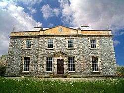 |
[15] |
| Magee University College, Northland Road, Derry | 55°00′24″N 7°19′25″W / 55.006633°N 7.323728°W | University/ College Building | Derry | – | A | HB01/22/009 A | 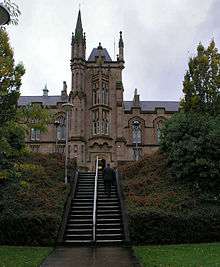 |
[16] |
| St Columb's Cathedral, St. Columb's Court, Derry | 54°59′38″N 7°19′24″W / 54.993822°N 7.323314°W | Church | Derry | – | A | HB01/19/001 | 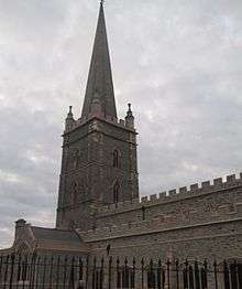 |
[17] |
| The Deanery, 30 Bishop Street, Derry | 54°59′41″N 7°19′23″W / 54.994597°N 7.323192°W | Rectories/ Manses Etc. | Derry | – | A | HB01/19/004 | |
[18] |
| Guildhall, Shipquay Place, Derry | 54°59′51″N 7°19′11″W / 54.997464°N 7.319614°W | Town Hall | Derry | – | A | HB01/19/038 | 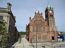 |
[19] |
| Bellarena House, Seacoast Road, Limavady | 55°06′41″N 6°57′39″W / 55.1113°N 6.9609°W | Country House | Limavady | A | A | HB02/09/002 A | |
[20] |
| Martello Tower, Point Road, Magilligan Limavady | 55°11′32″N 6°57′49″W / 55.1923°N 6.9637°W | Fort | Limavady | A | B | HB02/09/016 | |
[21] |
| Drenagh House, 15 Dowland Road, Fruithill, Limavady | 55°03′16″N 6°55′26″W / 55.0545°N 6.9239°W | Country House | Limavady | A | A | HB02/11/002 A | |
[22] |
| Ballykelly Presbyterian Church, Main Street, Ballykelly | 55°02′37″N 7°00′52″W / 55.0435°N 7.0144°W | Church | Limavady | A | A | HB02/10/006 | 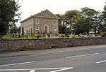 |
[23] |
| Dredge Bridge, Moyola Park, Castlepark, Magherafelt | 54°46′45″N 6°33′24″W / 54.779231°N 6.556744°W | Bridge | Magherafelt | – | A | HB08/10/032 | |
[24] |
| Court House, Union Road, Magherafelt | 54°45′32″N 6°36′38″W / 54.758789°N 6.610664°W | Court House | Magherafelt | – | A | HB08/15/009 | |
[25] |
Notes
- ↑ Sometimes known as OSGB36, the grid reference is based on the British national grid reference system used by the Ordnance Survey.
- ↑ The type of structure, as identified by the NIEA.
- ↑ The "HB Number" is a unique number assigned to each listed building by the NIEA.
| Wikimedia Commons has media related to Grade A listed buildings in County Londonderry. |
References
- ↑ "The Listing Process" (PDF). Northern Ireland Environment Agency. September 2008. Retrieved 2010-06-30.
- ↑ "Planning Policy Statement 6: Planning, Archaeology, and the Built Heritage" (PDF). Planning Service. March 1999. p. 48. Retrieved 2010-06-30.
- ↑ Legislation providing for the listing of buildings in England, Wales and Scotland was enacted in 1947.
- 1 2 3 4 "Criteria for Listing: A consultation on proposed revisions to Annex C of Planning Policy Statement 6" (PDF). Northern Ireland Environment Agency. 2010. Retrieved 2010-06-30.
- 1 2 3 "Second Survey". Northern Ireland Environment Agency. Retrieved 2010-06-30.
- ↑ "Planning Policy Statement 6: Planning, Archaeology, and the Built Heritage" (PDF). Planning Service. March 1999. p. 22. Retrieved 2010-06-30.
- ↑ Mussenden Temple, Downhill, Castlerock: Historic Building Details. Northern Ireland Buildings Database. Northern Ireland Environment Agency. Retrieved 2010-06-30.
- ↑ Cromore House, North Ballyleese, Coleraine: Historic Building Details. Northern Ireland Buildings Database. Northern Ireland Environment Agency. Retrieved 2010-06-30.
- ↑ Liffock House (a.k.a. Hezlett House), Liffock, Coleraine: Historic Building Details. Northern Ireland Buildings Database. Northern Ireland Environment Agency. Retrieved 2010-06-30.
- ↑ Springhill House, 20 Springhill Road, Moneymore, Magherafelt : Historic Building Details. Northern Ireland Buildings Database. Northern Ireland Environment Agency. Retrieved 2010-06-30.
- ↑ The Barn at Springhill, Moneymore, Magherafelt : Historic Building Details. Northern Ireland Buildings Database. Northern Ireland Environment Agency. Retrieved 2010-06-30.
- ↑ St Matthias Church of Ireland Church, Loup Road, Moneymore, Magherafelt : Historic Building Details. Northern Ireland Buildings Database. Northern Ireland Environment Agency. Retrieved 2010-06-30.
- ↑ 118 Ballyartan Road, Claudy : Historic Building Details. Northern Ireland Buildings Database. Northern Ireland Environment Agency. Retrieved 2010-06-30.
- ↑ Banagher Presbyterian Church, Glenshane Road, Claudy: Historic Building Details. Northern Ireland Buildings Database. Northern Ireland Environment Agency. Retrieved 2010-06-30.
- ↑ Prehen House, Prehen : Historic Building Details. Northern Ireland Buildings Database. Northern Ireland Environment Agency. Retrieved 2010-06-30.
- ↑ Magee University College, Northland Road, Derry: Historic Building Details. Northern Ireland Buildings Database. Northern Ireland Environment Agency. Retrieved 2010-06-30.
- ↑ St. Columb's Cathedral, St. Columb's Court, Derry: Historic Building Details. Northern Ireland Buildings Database. Northern Ireland Environment Agency. Retrieved 2010-06-30.
- ↑ The Deanery, 30 Bishop Street, Derry: Historic Building Details. Northern Ireland Buildings Database. Northern Ireland Environment Agency. Retrieved 2010-06-30.
- ↑ Guild Hall Shipquay Place Derry: Historic Building Details. Northern Ireland Buildings Database. Northern Ireland Environment Agency. Retrieved 2010-06-30.
- ↑ Bellarena House, Seacoast Road, Limavady: Historic Building Details. Northern Ireland Buildings Database. Northern Ireland Environment Agency. Retrieved 2010-06-30.
- ↑ Martello Tower, Point Road, Magilligan Limavady: Historic Building Details. Northern Ireland Buildings Database. Northern Ireland Environment Agency. Retrieved 2010-06-30.
- ↑ Drenagh House, 15 Dowland Road, Fruithill, Limavady: Historic Building Details. Northern Ireland Buildings Database. Northern Ireland Environment Agency. Retrieved 2010-06-30.
- ↑ Ballykelly Presbyterian Church, Main Street, Ballykelly: Historic Building Details. Northern Ireland Buildings Database. Northern Ireland Environment Agency. Retrieved 2010-06-30.
- ↑ Dredge Bridge, Moyola Park, Castlepark, Magherafelt: Historic Building Details. Northern Ireland Buildings Database. Northern Ireland Environment Agency. Retrieved 2010-06-30.
- ↑ Court House, Union Road, Magherafelt: Historic Building Details. Northern Ireland Buildings Database. Northern Ireland Environment Agency. Retrieved 2010-06-30.