List of Local Nature Reserves in Cambridgeshire

There are 27 Local Nature Reserves in Cambridgeshire.
Local government is divided between Cambridgeshire County Council and Peterborough City Council, which is a separate unitary authority. Under the county council, there are five district councils, Cambridge City Council, South Cambridgeshire District Council, East Cambridgeshire District Council, Huntingdonshire District Council and Fenland District Council.[1]
Key
Other classifications
- SSSI = Site of Special Scientific Interest
- WTBCN = Wildlife Trust for Bedfordshire, Cambridgeshire and Northamptonshire
Sites
| Site | Photograph | Area[lower-alpha 1] | Location[lower-alpha 2] | Borough | Other classifications | Map[lower-alpha 3] | Details[lower-alpha 4] | Description |
|---|---|---|---|---|---|---|---|---|
| Barnwell East | 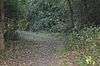 |
2.6 hectares (6.4 acres) | Cambridge 52°12′11″N 0°09′41″E / 52.203°N 0.1614°E TL 478 583 |
Cambridge | Map | Details | The site has woodland, a pond, scrub and grassland. Flora include blackthorns, hawthorns and bee orchids, there are birds such as blackcaps and willow warblers, and common blue and meadow brown butterflies.[3] | |
| Barnwell West | 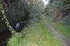 |
3.8 hectares (9.4 acres) | Cambridge 52°12′14″N 0°09′41″E / 52.204°N 0.1614°E TL 478 584 |
Cambridge | Map | Details | This is a linear site along Coldhams Brook, which is managed to encourage water voles. There are birds such as kingfishers, redwings and fieldfares, and butterflies include speckled woods and orange tips.[4] | |
| Beechwoods, TheThe Beechwoods | 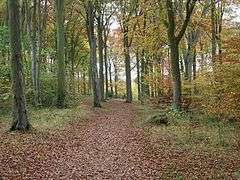 |
9.8 hectares (24 acres) | Cambridge 52°10′01″N 0°10′12″E / 52.167°N 0.1700°E TL 485 545 |
Cambridge | WTBCN | Map | Details | |
| Boardwalks, TheThe Boardwalks |  |
7.8 hectares (19 acres) | Peterborough 52°34′08″N 0°15′37″W / 52.569°N 0.2604°W TL 180 982 |
Peterborough | Map | Details | The site runs along the north bank of the River Nene. It has ponds with water beetles, frogs, toads and smooth newts. Bats nest in large willows, and birds include herons and woodpeckers.[5] | |
| Bramblefields | 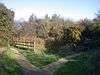 |
2.1 hectares (5.2 acres) | Cambridge 52°13′26″N 0°09′15″E / 52.224°N 0.1543°E TL 472 606 |
Cambridge | Map | Details | ||
| Byron's Pool | 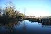 |
4.4 hectares (11 acres) | Grantchester 52°10′01″N 0°08′09″E / 52.167°N 0.1358°E TL 461 542 |
Cambridge | Map | Details | The site is named after Lord Byron, who used to swim in the pool. It is a linear pond and woodland next to the River Cam. Birds include little grebes and grey wagtails, and there are frogs, butterflies, damselflies and dragonflies.[6] | |
| Coldham's Common | 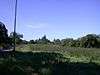 |
49.3 hectares (122 acres) | Cambridge 52°12′22″N 0°09′10″E / 52.206°N 0.1527°E TL 472 586 |
Cambridge | Map | Details | This site has areas of unimproved grassland, which have anthills of yellow meadow ants.[7] There is also scrub and woodland. Flora includes spiny rest harrow, upright brome and bee orchid.[8] | |
| Dogsthorpe Star Pit | 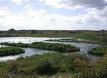 |
36.7 hectares (91 acres) | Peterborough 52°36′29″N 0°12′36″W / 52.608°N 0.2101°W TF 213 026 |
Peterborough | SSSI, WTBCN | Map | Details | |
| East Pit | 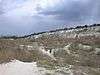 |
12.9 hectares (32 acres) | Cherry Hinton 52°10′52″N 0°10′12″E / 52.181°N 0.17000°E TL 484 558 |
Cambridge | SSSI,[9] WTBCN[10] | Map | Details | This site a variety of habitats, including grassland and woodland with ash trees, field maple and cherries. The area was designated an SSSI because it has four rare plants, three of which are listed in the British Red List of Threatened Species. These are great pignut, moon carrot and grape hyacinth.[9] |
| Eye Green |  |
12.0 hectares (30 acres) | Eye Green 52°36′52″N 0°11′05″W / 52.6145°N 0.1847°W TF 230 034 |
Peterborough | Map | Details | This site was formerly brick workings, and a large area is now filled by a lake. Reeds and scrub line much of the shore, providing cover for water birds such coots and moorhens, while dunnock and great tits nest in dense scrub. There is grassland with many flowers, and diverse invertebrate species.[11] | |
| Grimeshaw Wood | 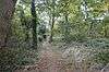 |
16.8 hectares (42 acres) | Peterborough 52°35′38″N 0°17′20″W / 52.594°N 0.2889°W TF 160 010 |
Peterborough | Map | Details | This site is ancient woodland in three adjacent areas. Flora include nettle-leaved bellflowers, and there are resident pipistrelle bats.[12] | |
| Isleham | 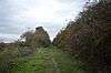 |
1.1 hectares (2.7 acres) | Isleham 52°19′41″N 0°24′07″E / 52.328°N 0.4019°E TL 637 726 |
East Cambridgeshire | Map | Details | This is a stretch of a former railway line. It is grassland and hedgerows with a wide variety of fauna and flora. There are flowering plants such as field scabious, greater knapweed, St John's wort, wild marjoram and bladder campion.[13] | |
| Kingston and Bourn Old Railway | 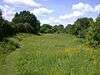 |
1.9 hectares (4.7 acres) | Toft 52°11′06″N 0°02′34″W / 52.185°N 0.04283°W TL 339 559 |
South Cambridgeshire | Map | Details | ||
| Lattersey Field | 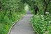 |
11.9 hectares (29 acres) | Whittlesey 52°33′07″N 0°06′38″W / 52.552°N 0.1106°W TL 282 966 |
Fenland | WTBCN | Map | Details | |
| Limekiln Close and West Pit | 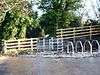 |
2.9 hectares (7.2 acres) | Cherry Hinton 52°10′56″N 0°10′14″E / 52.1823°N 0.1706°E TL 485 560 |
Cambridge | SSSI, WTBCN | Map | Details | |
| Little Downham |  |
6.6 hectares (16 acres) | Little Downham 52°25′37″N 0°14′02″E / 52.427°N 0.2340°E TL 524 834 |
East Cambridgeshire | Map | Details | The site consists of three areas of land, Pingle Wood, Myles Meadow and The Holts. Myles Meadow has two ponds and is seasonally grazed by cattle. Holts Meadow has a pond with many dragonflies and damselflies, including the emperor and scarce chaser dragonflies.[14] | |
| Little Paxton Pits | 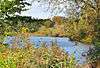 |
60.0 hectares (148 acres) | Little Paxton 52°15′29″N 0°14′36″W / 52.258°N 0.2433°W TL 200 637 |
Huntingdonshire | SSSI | Map | Details | |
| Logan's Meadow | 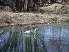 |
1.1 hectares (2.7 acres) | Cambridge 52°12′43″N 0°08′26″E / 52.212°N 0.1406°E TL 463 592 |
Cambridge | Map | Details | ||
| Mare Fen | 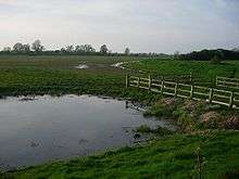 |
16.3 hectares (40 acres) | Swavesey 52°18′32″N 0°00′08″E / 52.309°N 0.0022°E TL 366 698 |
South Cambridgeshire | Map | Details | ||
| Melwood | 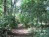 |
0.6 hectares (1.5 acres) | Meldreth 52°05′42″N 0°00′40″E / 52.095°N 0.01104°E TL 378 459 |
South Cambridgeshire | YES | Map | Details | This is a woodland site next to the River Mel, with trees such as ash, hawthorn, sycamore, beech and silver birch. Ground flora include dog violet and cow parsley, while traveller's joy provides food for moths. Tawny owls and pipistrelle bats roost on ivy.[15] |
| Nine Wells | 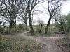 |
1.2 hectares (3.0 acres) | Great Shelford 52°10′01″N 0°08′05″E / 52.167°N 0.1348°E TL 461 542 |
Cambridge | Map | Details | ||
| Paradise | 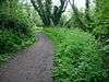 |
2.2 hectares (5.4 acres) | Cambridge 52°11′38″N 0°06′51″E / 52.194°N 0.1141°E TL 446 572 |
Cambridge | Map | Details | ||
| Ring's End |  |
8.5 hectares (21 acres) | March 52°35′42″N 0°04′10″E / 52.595°N 0.0695°E TF 402 017 |
Fenland | Map | Details | This is a linear site along a disused railway embankment, with views over the Fens. There are also three ponds, reedbeds and areas of scrub.[16] The soil is poor in nutrients, which has allowed uncommon flowering plants such as coltsfoot to become established..[17] | |
| Sheep's Green and Coe Fen | 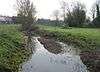 |
16.9 hectares (42 acres) | Cambridge 52°11′49″N 0°06′57″E / 52.197°N 0.1157°E TL 447 575 |
Cambridge | Map | Details | ||
| Somersham |  |
8.9 hectares (22 acres) | Somersham 52°23′02″N 0°00′22″E / 52.384°N 0.0061°E TL 366 781 |
Huntingdonshire | Map | Details | Habitats in this reserve are a lake, wetland, grassland and woodland. Invertebrates include grass snakes and common lizards, there are birds such as great crested grebes, and flora such as red bartsia and purple loosestrife.[18] | |
| St Denis Church (footprint of church only) | 0.02 hectares (0.049 acres) | Hatley 52°08′17″N 0°07′26″W / 52.138°N 0.1238°W TL 285 505 |
South Cambridgeshire | Map | Details | |||
| Woodston Ponds | 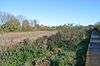 |
8.9 hectares (22 acres) | Peterborough 52°34′05″N 0°15′51″W / 52.568°N 0.2642°W TL 177 980 |
Peterborough | WTBCN[19] | Map | Details | The site was formerly settling ponds to remove washings from sugar beet. The east side has a lake with water birds such as grey herons, tufted ducks and pochards. In the west there is a reedbed which has pools and channels, with great crested newts and unusual species of water beetle.[19] |
See also
Notes
- ↑ The area is taken from the Natural England map of each site. (Click on the identify icon (i) in the "Feature Tools" and then click on the site.)[2]
- ↑ The location is taken from the Natural England details page for the site.
- ↑ The maps are on the Natural England database of Local Nature Reserves.
- ↑ Details are on the pages on each site in the Natural England database of Local Nature Reserves.[2]
References
- ↑ "Local government in Cambridgeshire". Cambridgeshire County Council. Retrieved 25 July 2016.
- 1 2 "Local Nature Reserves: Search Results for Cambridgeshire". Natural England. Retrieved 26 July 2016.
- ↑ "Barnwell East". Local Nature Reserves. Natural England. 20 February 2013. Retrieved 26 October 2016.
- ↑ "Barnwell II West". Local Nature Reserves. Natural England. 20 February 2013. Retrieved 26 October 2016.
- ↑ "The Boardwalks". Local Nature Reserves. Natural England. 21 February 2013. Retrieved 1 November 2016.
- ↑ "Byron's Pool". Local Nature Reserves. Natural England. 20 February 2013. Retrieved 26 October 2016.
- ↑ "Coldham's Common". Local Nature Reserves. Natural England. 20 February 2013. Retrieved 26 October 2016.
- ↑ "Coldham's Common". Cambridge City Council. Retrieved 26 October 2016.
- 1 2 "Cherry Hinton Pit citation" (PDF). Sites of Special Scientific Interest. Natural England. Retrieved 30 November 2016.
- ↑ "Cherry Hinton Chalk Pits". Wildlife Trust for Bedfordshire, Cambridgeshire and Northamptonshire. Retrieved 30 November 2016.
- ↑ "Eye Green". Local Nature Reserves. Natural England. 20 February 2013. Retrieved 9 October 2016.
- ↑ "Grimeshaw Wood". Local Nature Reserves. Natural England. 20 February 2013. Retrieved 1 November 2016.
- ↑ "Isleham". Local Nature Reserves. Natural England. Retrieved 9 November 2016.
- ↑ "Little Downham". Local Nature Reserves. Natural England. 21 February 2013. Retrieved 14 November 2016.
- ↑ "Local nature reserves : Melwood". Cambridgeshire County Council. Retrieved 2 October 2016.
- ↑ "Ring's End". Local Nature Reserves. Natural England. 21 February 2013. Retrieved 20 November 2016.
- ↑ "Local nature reserves : Ring's End". Cambridgeshire County Council. Retrieved 20 November 2016.
- ↑ "Somersham". Local Nature Reserves. Natural England. 21 February 2013. Retrieved 4 December 2016.
- 1 2 "Woodston Ponds". Wildlife Trust for Bedfordshire, Cambridgeshire and Northamptonshire. Retrieved 20 November 2016.
Coordinates: 52°20′N 0°0′W / 52.333°N -0.000°E
This article is issued from Wikipedia - version of the 12/4/2016. The text is available under the Creative Commons Attribution/Share Alike but additional terms may apply for the media files.