List of Sites of Special Scientific Interest in Cornwall
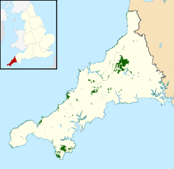
There are 167 Sites of Special Scientific Interest (SSSIs) in Cornwall (including the Isles of Scilly). Cornwall, in the south-west of England, UK, has a population of 545,335 (mid-2014 est.) across an area of 3,546 km2 (876,235.7 acres), making it one of the least densely populated counties within England.[1] The north coast of Cornwall falls on the Celtic Sea in the Atlantic Ocean, which also surrounds the Isles of Scilly, the south coast falls on the English Channel and the county is bounded by the River Tamar, forming the border with Devon, to the east. Cornish geology consists mainly of rocks from the Devonian and Carboniferous geological periods. Granite forms a large part of these, with mineralisations of tin, copper, lead and arsenic having been mined in the area.[2] This gives rise to many distinct habitats, with strong marine influences, including sand dunes, rocky reefs, stacks and headlands as well as heathland, moorland and unusual river profiles.[3]
In England the body responsible for designating SSSIs is Natural England, which chooses a site "because of its flora, fauna, or geological or physiographical features".[4] Natural England took over the role of designating and managing SSSIs from English Nature in October 2006 when it was formed from the amalgamation of English Nature, parts of the Countryside Agency and the Rural Development Service. Natural England, like its predecessor, uses the 1974–96 county system[5] and as such the same approach is followed here, rather than adopting the current local government or ceremonial county boundaries.
Of the 167 sites designated in this Area of Search, the greatest number, 81, have been designated due to their biological interest, with 54 due to their geological interest and 32 for both.[6] The data in the table is taken from English Nature in the form of citation sheets for each SSSI.[7]
Sites
See also
| Wikimedia Commons has media related to Sites of Special Scientific Interest in Cornwall. |
- List of Sites of Special Scientific Interest by Area of Search
- List of Special Areas of Conservation in Cornwall
Notes
- A Reason for designation; either for the site's biological interest, or its geological interest.
- B Data rounded to one decimal place.
- C Grid reference is based on the British national grid reference system, also known as OSGB36, and is the system used by the Ordnance Survey.[8]
- D Link to maps using the Nature on the Map service provided by Natural England.
References
- ↑ "Population estimates for UK mid-2014 analysis tool" (zip). Office for National Statistics. 25 June 2015. Retrieved 27 June 2015.
- ↑ "Geodiversity: Cornwall (inc Isles of Scilly)". Natural England. Retrieved 16 November 2011.
- ↑ "AONB: Cornwall". Natural England. Retrieved 16 November 2011.
- ↑ "Guidelines for selection of biological SSSIs". Joint Nature Conservation Committee. Retrieved 12 January 2016.
- ↑ "County search of SSSIs". Natural England. Retrieved 16 November 2011.
- ↑ "SSSIs in Cornwall". Natural England. Retrieved 16 November 2011.
- ↑ Natural England citation sheets for each SSSI (PDF). Retrieved 1 November 2011.
- "Aire Point to Carrack Du" (PDF).
- "Amble Marshes" (PDF).
- "Annet" (PDF).
- "Baulk Head to Mullion" (PDF).
- "Bedruthan Steps and Park Head" (PDF).
- "Belowda Beacon" (PDF).
- "Big Pool and Browarth Point (St Agnes)" (PDF).
- "Boconnoc Park and Woods" (PDF).
- "Bodmin Moor, North" (PDF).
- "Borlasevath and Retallack Moor" (PDF).
- "Boscastle to Widemouth" (PDF).
- "Boscawen" (PDF).
- "Brendonmoor" (PDF).
- "Breney Common" (PDF).
- "Bude Coast" (PDF).
- "Cabilla Manor Wood" (PDF).
- "Caerthillian to Kennack" (PDF).
- "Cameron Quarry" (PDF).
- "Carn Grey Rock and Quarry" (PDF).
- "Carnkeif Pond" (PDF).
- "Carrick Heaths" (PDF).
- "Carricknath Point to Porthbean Beach" (PDF).
- "Carrine Common & Penwethers" (PDF).
- "Castle Down (Tresco)" (PDF).
- "Chapel Down (St Martin's)" (PDF).
- "Chyenhal Moor" (PDF).
- "Clicker Tor Quarry" (PDF).
- "Cligga Head" (PDF).
- "Coombe Mill" (PDF).
- "Coverack Cove and Dolor Point" (PDF).
- "Coverack to Porthoustock" (PDF).
- "Crocadon Quarry" (PDF).
- "Crow's Nest" (PDF).
- "Crowhill Valley" (PDF).
- "Cuckoo Rock to Turbot Point" (PDF).
- "Cudden Point to Prussia Cove" (PDF).
- "De Lank Quarries" (PDF).
- "Dozmary Pool" (PDF).
- "Draynes Wood" (PDF).
- "Duckpool to Furzey Cove" (PDF).
- "East Lizard Heathlands" (PDF).
- "Eastern Isles" (PDF).
- "Eglarooze Cliff" (PDF).
- "Folly Rocks" (PDF).
- "Gerrans Bay to Camels Cove" (PDF).
- "Godrevy Head to St Agnes" (PDF).
- "Goonhilly Downs" (PDF).
- "Goss and Tregoss Moors" (PDF).
- "Great Pool (Tresco)" (PDF).
- "Great Wheal Fortune" (PDF).
- "Greenamoor" (PDF).
- "Greenscoombe Wood, Luckett" (PDF).
- "Greystone Quarry" (PDF).
- "Grimmscott" (PDF).
- "Gugh" (PDF).
- "Gwithian to Mexico Towans" (PDF).
- "Harbour Cove" (PDF).
- "Hawkstor Pit" (PDF).
- "Hayle Estuary & Carrack Gladden" (PDF).
- "Higher Moors and Porth Hellick Pool (St Mary's)" (PDF).
- "Hingston Down Quarry & Consols" (PDF).
- "Kelsey Head" (PDF).
- "Kennack to Coverack" (PDF).
- "Kernick and Ottery Meadows" (PDF).
- "Kingsand to Sandway Point" (PDF).
- "Lidcott Mine" (PDF).
- "Loe Pool" (PDF).
- "Loggans Moor" (PDF).
- "Lower Bostraze and Leswidden" (PDF).
- "Lower Fal & Helford Intertidal" (PDF).
- "Lower Moor (St Mary's)" (PDF).
- "Luxulyan Quarry" (PDF).
- "Lymsworthy Meadows" (PDF).
- "Lynher Estuary" (PDF).
- "Malpas Estuary" (PDF).
- "Marazion Marsh" (PDF).
- "Meddon Moor" (PDF).
- "Meneage Coastal Section" (PDF).
- "Merthen Wood" (PDF).
- "Minster Church" (PDF).
- "Mulberry Downs Quarry" (PDF).
- "Mullion Cliff to Predannack Cliff" (PDF).
- "Nance Wood" (PDF).
- "Newlyn Downs" (PDF).
- "Norrard Rocks" (PDF).
- "Ottery Valley" (PDF).
- "Park Wood" (PDF).
- "Penberthy Croft Mine" (PDF).
- "Penhale Dunes" (PDF).
- "Peninnis Head (St. Mary's)" (PDF).
- "Penlee Point" (PDF).
- "Penlee Quarry" (PDF).
- "Pentire Peninsula" (PDF).
- "Pentle Bay, Merrick and Round Islands" (PDF).
- "Phoenix United Mine" (PDF).
- "Plains and Great Bay (St Martin's)" (PDF).
- "Plymouth Sound Shores and Cliffs" (PDF).
- "Polruan to Polperro" (PDF).
- "Polyne Quarry" (PDF).
- "Polyphant" (PDF).
- "Pool of Bryher & Popplestone Bank (Bryher)" (PDF).
- "Porth Seal (St Martin's)" (PDF).
- "Porthcew" (PDF).
- "Porthgwarra to Pordenack Point" (PDF).
- "Porthleven Cliffs" (PDF).
- "Porthleven Cliffs East" (PDF).
- "Porthloo" (PDF).
- "Rame Head & Whitsand Bay" (PDF).
- "Red Moor" (PDF).
- "Redlake Meadows & Hoggs Moor" (PDF).
- "Retire Common" (PDF).
- "River Camel Valley and Tributaries" (PDF).
- "Roche Rock" (PDF).
- "Rock Dunes" (PDF).
- "Rosemullion" (PDF).
- "Rosenannon Bog and Downs" (PDF).
- "Rosenun Lane" (PDF).
- "Rushy Bay and Heathy Hill" (PDF).
- "Samson (with Green, White, Puffin and Stony Islands)" (PDF).
- "Shipman Head & Shipman Down (Bryher)" (PDF).
- "South Terras Mine" (PDF).
- "St Agnes Beacon Pits" (PDF).
- "St Austell Clay Pits" (PDF).
- "St Erth Sand Pits" (PDF).
- "St Helen's (With Northwethel & Men-a-vaur)" (PDF).
- "St John's Lake" (PDF).
- "St Martin's Sedimentary Shore" (PDF).
- "St Mewan Beacon" (PDF).
- "St Michael's Mount" (PDF).
- "St Nectan's Glen" (PDF).
- "Steeple Point to Marsland Mouth" (PDF).
- "Stepper Point" (PDF).
- "Stourscombe Quarry" (PDF).
- "Swanpool" (PDF).
- "Sylvia's Meadow" (PDF).
- "Talland Barton" (PDF).
- "Tamar – Tavy Estuary" (PDF).
- "Tater–du" (PDF).
- "Teän" (PDF).
- "Tintagel Cliffs" (PDF).
- "Trebetherick Point" (PDF).
- "Treen Cliff" (PDF).
- "Tregargus Quarries" (PDF).
- "Tregonetha & Belowda Downs" (PDF).
- "Tregonning Hill" (PDF).
- "Trehane Barton" (PDF).
- "Trelavour Downs" (PDF).
- "Trelow Downs" (PDF).
- "Tremearne Par" (PDF).
- "Trevaunance Cove" (PDF).
- "Trevone Bay" (PDF).
- "Trevose Head And Constantine Bay" (PDF).
- "Upper Fal Estuary And Woods" (PDF).
- "Upper Fowey Valley" (PDF).
- "Ventongimps Moor" (PDF).
- "Viverdon Quarry" (PDF).
- "Watermill Cove" (PDF).
- "West Cornwall Bryophytes" (PDF).
- "West Lizard" (PDF).
- "Western Rocks" (PDF).
- "Wheal Alfred" (PDF).
- "Wheal Gorland" (PDF).
- "Wheal Martyn" (PDF).
- "Wheal Penrose" (PDF).
- "White Island (Off St. Martin's)" (PDF).
- "Wingletang Down (St Agnes)" (PDF).
- "Yeolmbridge Quarry" (PDF).
- ↑ "Guide to National Grid". Ordnance Survey. Retrieved 2 July 2007.