List of former municipalities in New York City
The City of Greater New York was formed in 1898 through the consolidation of a number of municipalities, some of which were themselves consolidated from smaller municipalities. This article lists the towns and cities that have formerly existed within the current boundaries of New York city, from the time the British assumed control of New Amsterdam until the 1898 consolidation. The term "town" refers to county divisions usually known as townships elsewhere.
Manhattan
- City of New York
- Town of New Harlem (Nieuw Haarlem) - chartered 1658, annexed to New York in 1666[1][2]
The Bronx
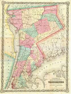
The Bronx was annexed from Westchester County by New York County (and New York City) in 1874 (west of Bronx River) and 1895 (east of it). Those two parts were established as a separate borough upon the consolidation of Greater New York in 1898, but was not legally established as a separate county, Bronx County, until 1914.
- Town of Eastchester (part) - annexed to New York in 1895
- Town of Kingsbridge - separated from Yonkers in 1873; annexed to New York in 1874
- Town of Morrisania - separated from West Farms in 1855; annexed to New York in 1874
- Village of Morrisania - incorporated within the Town of Morrisania in 1864[3]
- Town of Pelham (part) - annexed to New York in 1895
- Village of Wakefield - incorporated within the Town of Eastchester in 1889[4]
- Town of Westchester - annexed to New York in 1895
- Town of West Farms - separated from Westchester Town in 1846; annexed to New York in 1874
- Village of Williamsbridge - incorporated within the Town of Westchester in 1888[5]
- Town of Yonkers (part) - the part that would later be incorporated into the Bronx separated as Kingsbridge in 1873
Kings County
When it was created in 1688 Kings County contained six towns.[6][7] The City of Brooklyn eventually annexed the other towns and cities in Kings County between 1854 and 1896, before itself becoming part of New York City in 1898.[8]
- Town of Brooklyn, founded as "Breuckelen" in 1646, Brooklyn was one of the "Six Towns" of Kings County; incorporated as a city in 1834
- Village of Brooklyn, incorporated within the town in 1816 (its boundaries roughly match those of present-day neighborhood of Brooklyn Heights),[9] became part of the city of Brooklyn in 1834
- City of Brooklyn, the entire town of Brooklyn became a city in 1834.[10]
- Town of Bushwick - founded as "Boswijck" in 1661, annexed to Brooklyn in 1854
- Town of Flatbush - founded as "Midwout" in 1652; was county seat of Kings County; annexed to Brooklyn in 1894
- Town of Flatlands - founded as "Nieuw Amersfoort" in 1647; annexed to Brooklyn in 1896
- Town of Gravesend - founded in 1645; annexed to Brooklyn in 1894
- Town of New Lots - separated from Flatbush in 1852; annexed to Brooklyn in 1886
- Town of New Utrecht - founded in 1657 as Nieuw Utrecht; annexed to Brooklyn in 1894
- Town of Williamsburgh - separated from Town of Bushwick in 1840; became a city in 1851, annexed to Brooklyn in 1854
Queens County
All of Flushing, Jamaica, Long Island City, and Newtown, as well as the Rockaway Peninsula portion of Hempstead, consolidated into Greater New York in 1898. The rest of Hempstead and the Towns of North Hempstead and Oyster Bay split from Queens County to form Nassau County in 1899. Prior to consolidation, Lloyd Neck, which was then part of the Town of Oyster Bay and had earlier been known as Queens Village, seceded from Queens County and became part of the Town of Huntington in Suffolk County in 1885.[11][12]
- Village of College Point, incorporated within Flushing in 1880[13]
- Village of Far Rockaway, incorporated within the Rockaway Peninsula portion of Hempstead in 1888[14]
- Town of Flushing, chartered 1645 as Vlissingen[15]
- Village of Flushing, incorporated within the Town of Flushing in 1837[16]
- Town of Hempstead (part)
- Town of Jamaica[17]
- Village of Jamaica, incorporated within the Town of Jamaica in 1814
- City of Long Island City (separated from Newtown in 1870)
- Town of Newtown, chartered as Middelburgh in 1652,[18]:26 renamed Hastings in 1663[18]:59 and then New Towne in 1665.[18]:66
- Village of Richmond Hill, incorporated within the Town of Jamaica in 1894[14]
- Village of Rockaway Beach, incorporated within the Rockaway Peninsula portion of Hempstead in 1897[14]
- Village of Whitestone, incorporated within Flushing in 1868
Richmond County
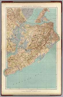
All of Staten Island consolidated into Greater New York in 1898.
- Town of Castleton
- Village of Edgewater - incorporated within the Town of Middletown in 1866[19]
- Town of Northfield
- Town of Middletown - formed in 1860 from parts of Castleton and Southfield
- Village of New Brighton - incorporated within the Town of Castleton on April 26, 1866[20]
- Village of Port Richmond - incorporated within Northfield in April 24, 1866[20]
- Village of Richmond - incorporated within the Town of Southfield in 1823[21]
- Town of Southfield
- Village of Tottenville - incorporated within the Town of Westfield under special conditions on April 28, 1869 & reincorporated under standard village conditions in 1894[22]
- Town of Westfield
References
- ↑ Gibson, Ellen (2004). Gibson's New York Legal Research Guide (PDF). Buffalo: Wm. S. Hein. p. 409.
English patents granted [in 1666 and 1678] made New York City coextensive with Manhattan Island, Harlem effectively became a town within the city.
- ↑ For example, see Colton, Topographical Map of the City and County of New York, 1836, (at http://www.davidrumsey.com/) which shows by a thin line "original boundary between New York and Harlem"
- ↑ http://s-media.nyc.gov/agencies/lpc/arch_reports/90.pdf
- ↑ https://books.google.ca/books?id=nqslAQAAIAAJ&pg=PR9&lpg=PR9&dq=1888+boundaries+%22Village+of+Far+Rockaway%22&source=bl&ots=Mdn023p5Hi&sig=MlBl1mUy2c_beiH_RYErWvuzHW4&hl=en&sa=X&ved=0ahUKEwipmN6C5YzOAhUPwWMKHTa5B-gQ6AEIJjAC#v=onepage&q=1888%20boundaries%20%22Village%20of%20Far%20Rockaway%22&f=false
- ↑ https://books.google.ca/books?id=nqslAQAAIAAJ&pg=PR9&lpg=PR9&dq=1888+boundaries+%22Village+of+Far+Rockaway%22&source=bl&ots=Mdn023p5Hi&sig=MlBl1mUy2c_beiH_RYErWvuzHW4&hl=en&sa=X&ved=0ahUKEwipmN6C5YzOAhUPwWMKHTa5B-gQ6AEIJjAC#v=onepage&q=1888%20boundaries%20%22Village%20of%20Far%20Rockaway%22&f=false
- ↑ Brooklyn Revealed Interactive map of six original towns
- ↑ Ellis, Edward Robb (1966). The Epic of New York City. Old Town Books. p. 53.
- ↑ Jackson, Kenneth (1995). Encyclopedia of New York City. New Haven: Yale University Press.
- ↑ Stiles, Henry Reed (1867-9). The Village of Brooklyn in 1816. Compiled from the first village map of that date by Jeremiah Lott, and Lott's map of the Pierrepont Estate of 1819. Check date values in:
|date=(help) - ↑ Gibson, Ellen M (1998). Gibson's New York Legal Research Guide. Buffalo: William S. Hein & Co. p. 403: "In 1834, over the objections of New York [City], it [(Brooklyn)] became a city comprising the entire area of the former town of Brooklyn."
- ↑ "Beers' Atlas of Long Island". 1873. Retrieved 2011-11-26.
- ↑ "LLOYD HARBOR – A BRIEF HISTORY". Incorporated Village of Lloyd Harbor, Suffolk County, NY. Retrieved 2011-11-26.
- ↑ http://s-media.nyc.gov/agencies/lpc/arch_reports/544.pdf
- 1 2 3 http://www.queensalive.org/queensalive_history.php
- ↑ "Pluralism Commentary". Religion and Ethic Newsweekly. PBS. Retrieved 17 January 2013.
- ↑ http://bklyn-genealogy-info.stevemorse.org/Queens/history/flushing.html
- ↑ 1891 Map of Queens County, New York
- 1 2 3 Riker, James, Jr. (1852). The annals of Newtown, in Queens County, New York. New York: Fanshaw.
- ↑ https://archive.org/stream/gazetteerofstate00houg#page/565/mode/2up
- 1 2 https://archive.org/stream/historyofrichmon00bayl/historyofrichmon00bayl_djvu.txt
- ↑ https://www.flickr.com/photos/emilio_guerra/6178042221
- ↑ http://www.tottenvillememories.net/villageoftottenville.htm