List of listed buildings in Glasgow/6
This is a list of listed buildings in Glasgow, Scotland.
List
| Name | Location | Date Listed | Grid Ref. [note 1] | Geo-coordinates | Notes | HB Number [note 2] | Image |
|---|---|---|---|---|---|---|---|
| 6 Spencer Street, Temple Primary School With Boundary Walls, Gates And Railings | 55°53′41″N 4°19′32″W / 55.894833°N 4.325675°W | Category C(S) | 43039 | 
| |||
| 147-149 (Odd Nos) Newlands Road, Weir Pumps Ltd Cathcart Works, Offices And Amenity Building | 55°49′06″N 4°15′57″W / 55.818416°N 4.265736°W | Category B | 33947 | 
| |||
| 1110 Pollokshaws Road, 4 Moss-Side Road, Tsb Bank | 55°49′51″N 4°16′51″W / 55.830736°N 4.280904°W | Category B | 33955 |
| |||
| Pollokshaws Road, Pollockshaws West Station Including Embankment Wall To Street | 55°49′26″N 4°18′06″W / 55.823879°N 4.301625°W | Category B | 33959 | 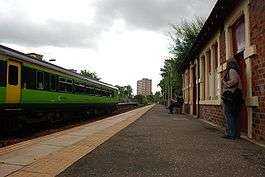
| |||
| Shawhill Road, War Memorial At St Mary Immaculate Rc Church | 55°49′33″N 4°17′33″W / 55.825836°N 4.292591°W | Category B | 33966 |
| |||
| 1, 13 Circus Drive, Golfhill Public School Including Janitor's Lodge, Gates And Railings | 55°51′45″N 4°13′34″W / 55.862457°N 4.226221°W | Category B | 33892 |
| |||
| 116-120A (Even Nos) Duke Street, And 214 Hunter Street | 55°51′33″N 4°13′56″W / 55.859184°N 4.232266°W | Category C(S) | 33898 |
| |||
| 288-294 (Even Nos) Duke Street, 98-106 (Even Nos) Bellgrove Street | 55°51′29″N 4°13′27″W / 55.857947°N 4.224157°W | Category B | 33900 |
| |||
| 300 Barrhead Road, Lodge And Gateway To Pollock House | 55°49′21″N 4°19′07″W / 55.822626°N 4.318554°W | Category B | 33916 |
| |||
| 83 Langside Drive, The Beeches Including Gatepiers | 55°48′43″N 4°16′43″W / 55.812075°N 4.278646°W | Category B | 33933 |
| |||
| 217 London Road 18, 20 Stevenson Street, St Alphonsus Rc Church And Presbytery | 55°51′15″N 4°14′15″W / 55.854099°N 4.237598°W | Category B | 33852 |
| |||
| 62 Templeton Street, Templeton Carpet Factory | 55°51′01″N 4°13′58″W / 55.850379°N 4.23264°W | Category A | 33857 | 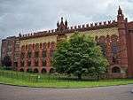
| |||
| 9, 11, 13 Watson Street, 31 Gallowgate | 55°51′24″N 4°14′34″W / 55.856712°N 4.242686°W | Category B | 33861 |
| |||
| 105-169 (Odd Nos) Bell Street | 55°51′27″N 4°14′31″W / 55.857621°N 4.242083°W | Category A | 33814 |
| |||
| 174 Bell Street | 55°51′25″N 4°14′27″W / 55.856872°N 4.240794°W | Category B | 33817 |
| |||
| 40-42 (Even Nos) Bridgeton Cross And 3 Landressy Street | 55°50′57″N 4°13′39″W / 55.849243°N 4.227382°W | Category B | 33821 |
| |||
| 2 Claythorn Street (Formerly 374, 378 Gallowgate) | 55°51′20″N 4°13′59″W / 55.85552°N 4.233094°W | Category B | 33824 |
| |||
| 231 Dalmarnock Road, Bridgeton Free Church And Hall | 55°50′42″N 4°13′11″W / 55.845041°N 4.219682°W | Category B | 33825 |
| |||
| 447-451 (Odd Nos) Gallowgate And 4 Graham Square | 55°51′20″N 4°13′39″W / 55.855676°N 4.227495°W | Category C(S) | 33833 |
| |||
| 4 Florence Street/ Glasgow Green, Weir And Pipe Bridge | 55°51′07″N 4°14′45″W / 55.852036°N 4.24574°W | Category B | 33835 |
| |||
| 1, 1A Glasgow Green, People's Palace Museum And Winter Garden | 55°51′04″N 4°14′15″W / 55.851209°N 4.237416°W | Category A | 33838 | 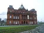
| |||
| 2-40 (Even Nos) Clarendon Place/ Maryhill Road And 281-297 (Odd Nos) St George's Road, Including Bank Of Scotland | 55°52′17″N 4°16′04″W / 55.871367°N 4.26786°W | Category B | 33755 | 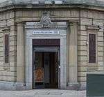
| |||
| 292-316 (Even Nos) Maryhill Road, Community Centre And Shops | 55°52′35″N 4°16′15″W / 55.876514°N 4.270958°W | Category C(S) | 33774 | 
| |||
| 61 Jessie Street, Sentinel Works | 55°50′07″N 4°14′32″W / 55.835275°N 4.242298°W | Category A | 33693 |
| |||
| 192 Mcneil Street, Hutcheson Town Public Library (Now Day Nursery) | 55°50′46″N 4°14′32″W / 55.846126°N 4.24214°W | Category B | 33696 |
| |||
| 110 Polmadie Road, St Margaret's Polmadie Church, Halls And Manse | 55°50′20″N 4°14′22″W / 55.838996°N 4.239318°W | Category B | 33698 |
| |||
| 115 Carmunnock Road, Cathcart Old Parish Manse | 55°49′06″N 4°15′17″W / 55.818383°N 4.254799°W | Category B | 33706 |
| |||
| 325 Carmunnock Road, King's Park, Aikenhead House, Sundial | 55°48′49″N 4°14′27″W / 55.813633°N 4.240813°W | Category B | 33712 |
| |||
| 114 Crofthill Road, Croftpark Avenue, Croftfoot School | 55°48′54″N 4°14′02″W / 55.814891°N 4.233894°W | Category C(S) | 33713 |
| |||
| Snuffmill Road, Cathcart Old Bridge | 55°48′49″N 4°15′33″W / 55.813745°N 4.259239°W | Category B | 33722 |
| |||
| 694 Balmore Road, St Agnes Church (Roman Catholic) With Gatepiers, Boundary Walls And Railings | 55°53′45″N 4°15′49″W / 55.895784°N 4.263575°W | Category B | 33738 |
| |||
| 127 Allander Street, Possilpark Library | 55°52′56″N 4°15′17″W / 55.882124°N 4.254721°W | Category B | 33741 |
| |||
| 445 Balmore Road, Former Possil Goods Shed | 55°53′30″N 4°15′37″W / 55.891564°N 4.260402°W | Category C(S) | 33743 |
| |||
| 85, 111 Killin Street, Shettleston Old Parish Church And Hall, Boundary Wall And Railings | 55°51′00″N 4°09′33″W / 55.84999°N 4.159256°W | Category B | 33637 |
| |||
| 6-10 (Inclusive), 20-24 (Inclusive) And 30-43 (Inclusive) Parklands View, Former Leverndale Hospital, Kelburne Unit | 55°49′59″N 4°22′01″W / 55.833136°N 4.366944°W | Category B | 33596 |
| |||
| 179 Ayr Street Springburn Library And Museum | 55°52′54″N 4°13′53″W / 55.881605°N 4.231443°W | Category B | 33610 |
| |||
| Midwharf Street And North Canalbank Street, Forth And Clyde Canal, Bascule Bridge Including Stone Platforms/Abutments | 55°52′20″N 4°15′04″W / 55.872284°N 4.251193°W | Category B | 33617 |
| |||
| 4-38 (Even Nos) Speirs Wharf | 55°52′20″N 4°15′27″W / 55.872269°N 4.257411°W | Category B | 33619 |
| |||
| 122 Helenvale Street, Calton Parkhead Church Including Hall, Boundary Wall, Gates And Railings | 55°51′01″N 4°12′59″W / 55.850342°N 4.216278°W | Category B | 33636 |
| |||
| 2-20 (Even Nos) Paisley Road West And Return Elevation To Govan Road | 55°51′14″N 4°16′47″W / 55.853804°N 4.279603°W | Category B | 33526 |
| |||
| 100 Govan Road, Glasgow Harbour Tunnel, Otherwise Known As Finnieston Tunnel Shaft And Rotunda | 55°51′23″N 4°17′06″W / 55.8565°N 4.28497°W | Category B | 33528 | 
| |||
| 140 Salkeld Street And Return Elevation To Mauchline Street, Former Garage Now Strathclyde Police Mounted And Dog Branch | 55°50′52″N 4°15′43″W / 55.84775°N 4.261899°W | Category B | 33531 |
| |||
| 173 Scotland Street, Former Subway Power Station | 55°50′57″N 4°16′18″W / 55.849152°N 4.271662°W | Category B | 33532 |
| |||
| 1121 Paisley Road West, Palace Of Art | 55°50′51″N 4°19′06″W / 55.847501°N 4.31823°W | Category B | 33579 |
| |||
| 494-8 (Even Nos) Paisley Road West | 55°51′04″N 4°18′03″W / 55.851241°N 4.300958°W | Category B | 33580 |
| |||
| Crookston Castle, 170 Brockburn Road | 55°50′06″N 4°21′21″W / 55.83512°N 4.35587°W | Category A | 33586 |
| |||
| 100 St Andrews Drive, Haggs Castle, Including Outbuilding | 55°50′11″N 4°17′45″W / 55.836407°N 4.295865°W | Category B | 33467 |
| |||
| 35 Sherbrooke Avenue And 103 Springkell Avenue, Patrick House, Including Boundary Walls And Gatepiers | 55°50′21″N 4°17′55″W / 55.839233°N 4.298555°W | Category B | 33473 |
| |||
| 85 Adelphi Street And 5 Florence Street, Glasgow College Of Building & Printing Annexe (Former Adelphi Terrace Public School), Including Gatepiers And Railings | 55°51′05″N 4°14′48″W / 55.851274°N 4.246655°W | Category B | 33491 |
| |||
| 36-54 (Even Nos) Bridge Street, Former Bridge Street Station | 55°51′12″N 4°15′33″W / 55.853321°N 4.259043°W | Category B | 33496 | 
| |||
| 1 Caledonia Road, Former Caledonia Road Up Church | 55°50′50″N 4°15′17″W / 55.847181°N 4.254709°W | Category A | 33497 | 
| |||
| 27-117 (Odd Nos) Cook Street (Westbridge Gardens) And 181 And 183 West Street, Former Eglinton Engine Works | 55°51′03″N 4°15′54″W / 55.850831°N 4.264922°W | Category A | 33504 |
| |||
| 119 Gorbals Street Citizens Theatre | 55°51′03″N 4°15′11″W / 55.850817°N 4.252955°W | Category B | 33512 | 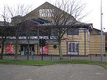
| |||
| 73 Milnpark Street, Kinning Park Colour Works | 55°51′06″N 4°16′57″W / 55.851537°N 4.282618°W | Category B | 33518 |
| |||
| 187-203 (Odd Nos) Old Rutherglen Road | 55°50′57″N 4°14′49″W / 55.849037°N 4.247069°W | Category B | 33521 |
| |||
| 50, 52 Glencairn Drive, Including Boundary Walls And Gatepiers | 55°50′21″N 4°16′58″W / 55.839105°N 4.282735°W | Category B | 33409 |
| |||
| 23 Maxwell Drive, Including Boundary Walls And Gatepiers | 55°50′43″N 4°16′55″W / 55.845176°N 4.282053°W | Category C(S) | 33423 |
| |||
| 33 Newark Drive, Including Boundary Walls And Gatepiers | 55°50′24″N 4°16′58″W / 55.839932°N 4.282736°W | Category B | 33430 |
| |||
| 58 Newark Drive, Ardlui, Including Boundary Walls And Gatepiers | 55°50′27″N 4°17′13″W / 55.840778°N 4.28705°W | Category C(S) | 33437 |
| |||
| 198 Nithsdale Road, Including Boundary Walls And Gatepiers | 55°50′32″N 4°17′08″W / 55.842088°N 4.28569°W | Category B | 33449 |
| |||
| 99 Dougrie Road, St Margaret Mary's Rc Church And Presbytery | 55°48′11″N 4°14′38″W / 55.803106°N 4.243942°W | Category B | 33331 |
| |||
| 401 Govan Road, Summertown Road Carmichael Street 1-11 Merryland Street (Odd Nos) Former Govan Town Hall | 55°51′24″N 4°18′00″W / 55.856615°N 4.300013°W | Category B | 33340 | 
| |||
| 784-796 (Even Nos) Govan Road, New Govan, Formerly St Mary's, Church Hall And Shops Below | 55°51′46″N 4°18′40″W / 55.862743°N 4.311115°W | Category B | 33349 |
| |||
| Govan Road, Govan Cross Drinking Fountain | 55°51′47″N 4°18′40″W / 55.863066°N 4.31115°W | Category B | 33350 |
| |||
| 840, 860 Govan Road And Return Elevation To Pearce Street, Pearce Institute | 55°51′49″N 4°18′46″W / 55.863558°N 4.312714°W | Category A | 33352 |
| |||
| 149-153 (Odd Nos) Albert Drive, St Alberts' Roman Catholic Church And Hall | 55°50′29″N 4°16′18″W / 55.841523°N 4.271552°W | Category B | 33367 |
| |||
| 363 (Dunmorlie), 363A Albert Drive, Including Boundary Walls And Gatepiers | 55°50′37″N 4°17′33″W / 55.843742°N 4.292448°W | Category B | 33373 |
| |||
| 50 Dalziel Drive, Including Boundary Walls And Gatepiers | 55°50′32″N 4°17′37″W / 55.842266°N 4.293543°W | Category B | 33374 |
| |||
| 150-174 (Even Nos) Albert Drive And 88-92 (Even Nos) Forth Street, 59, 61 Glenapp Street | 55°50′31″N 4°16′15″W / 55.842004°N 4.270814°W | Category B | 33376 |
| |||
| 336, 338 Albert Drive, Including Boundary Walls And Gatepiers | 55°50′40″N 4°17′11″W / 55.844456°N 4.286452°W | Category B | 33382 |
| |||
| 23 Bruce Road | 55°50′40″N 4°17′02″W / 55.844479°N 4.283753°W | Category B | 33389 |
| |||
| 38 And 38A Dalziel Drive, Hazliebrae, Including Boundary Walls And Gatepiers | 55°50′30″N 4°17′28″W / 55.841673°N 4.291112°W | Category B | 33396 |
| |||
| 4 Nelson Mandela Place | 55°51′44″N 4°15′13″W / 55.862361°N 4.253719°W | Category A | 33233 | 
| |||
| 112, 114 West George Street And 46-50 (Even Nos) Renfield Street, Scottish Widows | 55°51′45″N 4°15′22″W / 55.862571°N 4.255985°W | Category B | 33238 |
| |||
| 278 West George Street, Former St Jude's Church | 55°51′49″N 4°15′54″W / 55.86354°N 4.264863°W | Category B | 33250 |
| |||
| 58, 60 West Nile Street and 23 Nelson Mandela Place, West George Street | 55°51′43″N 4°15′17″W / 55.861902°N 4.254747°W | Category B | 33253 | 
| |||
| 130-134 (Even Nos) West Nile Street | 55°51′49″N 4°15′15″W / 55.863729°N 4.254118°W | Category C(S) | 33256 |
| |||
| 51-57 (Odd Nos) West Regent Street, 59-69 (Odd Nos) Renfield Street And 18-22 (Even Nos) West Regent Lane, Castle Chambers | 55°51′46″N 4°15′24″W / 55.862892°N 4.256643°W | Category B | 33257 |
| |||
| 121 West Regent Street, Ailsa Court | 55°51′48″N 4°15′36″W / 55.863271°N 4.259941°W | Category C(S) | 33267 |
| |||
| 98-104 (Even Nos) West Regent Street (Known As 100) | 55°51′49″N 4°15′30″W / 55.863544°N 4.258311°W | Category B | 33272 |
| |||
| 130, 132 West Regent Street | 55°51′49″N 4°15′35″W / 55.863679°N 4.259757°W | Category C(S) | 33274 |
| |||
| 148, 150 West Regent Street | 55°51′49″N 4°15′37″W / 55.863741°N 4.26032°W | Category B | 33276 |
| |||
| Springburn Park, Winter Gardens | 55°53′20″N 4°13′37″W / 55.889°N 4.227038°W | Category A | 33298 |
| |||
| 200 Shieldhall Road, Drumoyne Primary School, Janitor's Lodge Gatepiers And Boundary Walls | 55°51′22″N 4°19′55″W / 55.856032°N 4.331905°W | Category B | 33312 |
| |||
| 201, 203 Pitt Street And 309-313 (Odd Nos) Sauchiehall Street | 55°51′55″N 4°15′54″W / 55.865336°N 4.264983°W | Category C(S) | 33177 |
| |||
| 429-453 (Odd Nos) Sauchiehall Street | 55°51′57″N 4°16′10″W / 55.865921°N 4.269317°W | Category B | 33181 |
| |||
| 94-102 (Even Nos) Sauchiehall Street, Crown Rooms | 55°51′53″N 4°15′23″W / 55.864838°N 4.256356°W | Category B | 33188 |
| |||
| 116-120 (Even Nos) Sauchiehall Street And 257A, 259 Hope Street | 55°51′54″N 4°15′27″W / 55.86489°N 4.257446°W | Category B | 33189 |
| |||
| 500-516 (Even Nos) Sauchiehall Street, Known As 516 | 55°51′59″N 4°16′10″W / 55.866307°N 4.269355°W | Category B | 33197 |
| |||
| 528-538 (Even Nos) Sauchiehall Street, Albany Chambers | 55°51′59″N 4°16′12″W / 55.866365°N 4.270078°W | Category A | 33199 |
| |||
| 2-14 (Inclusive Nos) Somerset Place And 2, 4 Clifton Street (Sauchiehall Street) | 55°51′59″N 4°16′37″W / 55.866318°N 4.277012°W | Category B | 33202 |
| |||
| 54-76 (Even Nos) Union Street And 55, 57, 63 Mitchell Street | 55°51′34″N 4°15′23″W / 55.859321°N 4.256292°W | Category B | 33206 |
| |||
| 50 Waterloo Street With 81 Wellington Street, Former Waterloo Street Post Office, Parcels Office | 55°51′38″N 4°15′40″W / 55.860662°N 4.261068°W | Category A | 33214 |
| |||
| 65 St Vincent Street And 26, 28 West Nile Street | 55°51′40″N 4°15′18″W / 55.861114°N 4.255037°W | Category B | 33132 |
| |||
| 125, 127 St Vincent Street And 127, 129 Hope Street, Norwich Union Chambers | 55°51′41″N 4°15′31″W / 55.861469°N 4.258749°W | Category B | 33140 |
| |||
| 145 St Vincent Street, Wellington Street And 60-66 St Vincent Lane | 55°51′42″N 4°15′35″W / 55.861613°N 4.259701°W | Category B | 33142 | ||||
| 110, 120 St Vincent Street And 29-37 (Odd Nos) Renfield Street And West George Lane, Bank Of Scotland | 55°51′43″N 4°15′26″W / 55.861859°N 4.257094°W | Category A | 33156 |
| |||
| 188-192 (Even Nos) St Vincent Street | 55°51′44″N 4°15′38″W / 55.862198°N 4.260662°W | Category C(S) | 33161 | _ST_VINCENT_STREET.jpg)
| |||
| 2-5 (Inclusive Nos) La Belle Place | 55°52′00″N 4°16′47″W / 55.866554°N 4.279791°W | Category A | 33083 |
| |||
| 60-76 (Even Nos) Mitchell Street, Former Glasgow Herald Building | 55°51′35″N 4°15′20″W / 55.859631°N 4.255559°W | Category A | 33087 |
| |||
| 1-11 (Odd Nos) Renfield Street And 60-70 (Even Nos) Gordon Street | 55°51′39″N 4°15′26″W / 55.860811°N 4.257353°W | Category B | 33100 |
| |||
| 194 Renfrew Street | 55°52′00″N 4°15′54″W / 55.866547°N 4.265102°W | Category C(S) | 33109 |
| |||
| 71-75 (Odd Nos) Robertson Street And 58, 60 Robertson Lane | 55°51′30″N 4°15′42″W / 55.858244°N 4.261582°W | Category A | 33112 |
| |||
| 15 - 21 (Odd Nos) Gordon Street | 55°51′37″N 4°15′19″W / 55.860205°N 4.255144°W | Category B | 33026 |
| |||
| 2-10 (Even Nos) Bath Street And 229 Buchanan Street, Commercial Hotel | 55°51′49″N 4°15′12″W / 55.863618°N 4.253313°W | Category C(S) | 32964 |
| |||
| 8-13 (Inclusive Nos) Known As 8 Blythswood Square, 173 West Regent Street, 258 West George Street, 135 West Regent Lane, Royal Scottish Automobile Club | 55°51′48″N 4°15′43″W / 55.863415°N 4.261883°W | Category B | 32976 |
| |||
| 179 Buchanan Street, Former Athenaeum Theatre | 55°51′45″N 4°15′14″W / 55.862564°N 4.253923°W | Category A | 33004 |
| |||
| 1-9 (Odd Nos) Corunna Street And 1131-1143 (Odd Nos) Argyle Street | 55°51′52″N 4°17′05″W / 55.864447°N 4.284846°W | Category B | 33013 |
| |||
| 34, 38 Elliot Street (Known as 38 Elliot Street) | 55°51′43″N 4°16′45″W / 55.862011°N 4.279045°W | Category B | 33018 |
| |||
| 17 Vinicombe Street, The Salon Including Boundary Wall and Railings | 55°52′37″N 4°17′26″W / 55.876948°N 4.290664°W | Category A | 32934 | 
| |||
| 145-167 (Odd Nos) Bath Street, 257 West Campbell Street, And 144-148 (Even Nos) Bath Lane | 55°51′51″N 4°15′42″W / 55.864273°N 4.261693°W | Category B | 32959 |
| |||
| 201-205 (Odd Nos) Bath Street, Adelaide Place (South) | 55°51′52″N 4°15′51″W / 55.864462°N 4.264117°W | Category C(S) | 32961 |
| |||
| University Avenue, University Of Glasgow, Gatepiers And Railings Quincentenary Gates | 55°52′20″N 4°17′17″W / 55.872231°N 4.28818°W | Category B | 32915 | 
| |||
| 3-9A (Odd Nos) Burgh Hall Street, Partick Burgh Halls | 55°52′17″N 4°18′31″W / 55.871355°N 4.308622°W | Category B | 32852 |
| |||
| 174, 176 Byres Road And 1, 3 Ashton Road | 55°52′28″N 4°17′39″W / 55.874556°N 4.294136°W | Category B | 32854 |
| |||
| 41 Cresswell Street And 30 Cranworth Street, Hillhead Baptist Church | 55°52′34″N 4°17′29″W / 55.876045°N 4.291394°W | Category B | 32860 |
| |||
| 121 Great George Street, Extension To Laurel Bank School, Former Belmont Church | 55°52′29″N 4°17′27″W / 55.874743°N 4.290854°W | Category B | 32871 | 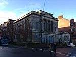
| |||
| 56 Glassford Street And 53 Hutcheson Street | 55°51′31″N 4°14′55″W / 55.858554°N 4.248609°W | Category C(S) | 32804 |
| |||
| 76-84 (Even Nos) Wilson Street With 58-68 (Even Nos) Virginia Street | 55°51′32″N 4°14′58″W / 55.858935°N 4.249414°W | Category B | 32809 |
| |||
| 4-6 (Even Nos) North Court | 55°51′39″N 4°15′09″W / 55.860695°N 4.252424°W | Category B | 32810 | 
| |||
| 32-44 (Even Nos) Queen Street | 55°51′31″N 4°15′07″W / 55.858673°N 4.251908°W | Category B | 32820 |
| |||
| Queen Street Station, Train Shed And Bridge Over Railway On Cathedral Street | 55°51′45″N 4°15′04″W / 55.86247°N 4.2512°W | Category A | 32822 | .jpg)
| |||
| Queen Street Duke Of Wellington Statue | 55°51′36″N 4°15′07″W / 55.8601°N 4.252038°W | Category A | 32823 | 
| |||
| 6 Rottenrow East And 1 Macleod Street, Castle Street, And Cathedral Square, Barony Church And Church Hall With War Memorial, Retaining Wall, Railings And Gatepiers | 55°51′43″N 4°14′14″W / 55.861882°N 4.237119°W | Category A | 32824 | 
| |||
| 102 Royston Road, Royston School, Formerly St Rollox School | 55°52′09″N 4°13′44″W / 55.869147°N 4.229018°W | Category B | 32829 |
| |||
| 2 St Vincent Place And 2 And 4 Anchor Lane | 55°51′40″N 4°15′07″W / 55.861208°N 4.251911°W | Category A | 32838 |
| |||
| 141-197 (Odd Nos) Howard Street With 63 Dunlop Street And 98-100 (Even Nos) Stockwell Street | 55°51′20″N 4°15′01″W / 55.855638°N 4.250294°W | Category B | 32725 |
| |||
| 72-82 (Even Nos) Howard Street | 55°51′23″N 4°15′14″W / 55.856353°N 4.253947°W | Category B | 32727 |
| |||
| 150 (Even Nos) Ingram Street | 55°51′35″N 4°14′50″W / 55.859774°N 4.247257°W | Category B | 32743 |
| |||
| 61-63 (Odd Nos) Miller Street | 55°51′33″N 4°15′05″W / 55.859161°N 4.251281°W | Category A | 32758 |
| |||
| 109-121 (Odd Nos) Trongate And 9 New Wynd, Including Britannia Panopticon Music Hall | 55°51′25″N 4°14′49″W / 55.856903°N 4.246964°W | Category A | 32774 |
| |||
| 82-92 (Even Nos) Castle Street, Royal Infirmary, Including Clock Tower Building And Archway, Gates And Railings | 55°51′54″N 4°14′08″W / 55.864938°N 4.235617°W | Category B | 32650 | 
| |||
| Cathedral Square, Bridge Of Sighs, Gates, Gatepiers, And Lodge To Bridge Of Sighs With 50 Cathedral Square (Superintendent's House) | 55°51′45″N 4°14′08″W / 55.862395°N 4.235614°W | Category A | 32651 |
| |||
| 20 Cathedral Square, Glasgow Evangelical Church; (Former Barony North Church) And Boundary Walls And Railings, And Church House, 14 Cathedral Square | 55°51′41″N 4°14′06″W / 55.861443°N 4.23508°W | Category A | 32652 | 
| |||
| 55-57 (Odd Nos) Cochrane Street And 20 South Frederick Street | 55°51′38″N 4°14′56″W / 55.860428°N 4.248845°W | Category C(S) | 32674 |
| |||
| 9 Garth Street With 76 Glassford Street | 55°51′33″N 4°14′55″W / 55.859183°N 4.248597°W | Category B | 32684 |
| |||
| 80 George Square Glasgow City Chambers And Lampbrackets To George Square | 55°51′40″N 4°14′55″W / 55.860988°N 4.24867°W | Category A | 32691 | 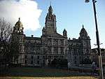
| |||
| 44 Glassford Street | 55°51′30″N 4°14′56″W / 55.858341°N 4.248932°W | Category B | 32714 |
| |||
| 252-284 (Even Nos) High Street And 1-5 (Odd Nos) Duke Street (Bell O'The Brae Tenements) | 55°51′38″N 4°14′20″W / 55.860547°N 4.23888°W | Category B | 32724 |
| |||
| 49-51 (Inclusive Nos) Westbourne Gardens | 55°52′53″N 4°18′12″W / 55.881315°N 4.303233°W | Category B | 32604 |
| |||
| 63 Argyle Street (Buck's Head Buildings) | 55°51′27″N 4°15′05″W / 55.85758°N 4.251269°W | Category A | 32608 |
| |||
| 6-20 (Even Nos) Bell Street | 55°51′29″N 4°14′43″W / 55.857948°N 4.245394°W | Category B | 32622 |
| |||
| 26-36 (Even Nos) Bell Street And 45 Albion Street | 55°51′28″N 4°14′42″W / 55.857856°N 4.244973°W | Category B | 32623 |
| |||
| 102-104 Brunswick Street, Known As 104 Brunswick Street | 55°51′32″N 4°14′48″W / 55.858857°N 4.246773°W | Category B | 32627 |
| |||
| 16 Buchanan Street | 55°51′31″N 4°15′16″W / 55.858565°N 4.254362°W | Category B | 32631 |
| |||
| 116-128 (Even Nos) Buchanan Street And 41 St Vincent Place (St Vincent Chambers) | 55°51′39″N 4°15′13″W / 55.860842°N 4.253727°W | Category B | 32641 |
| |||
| 125-127 (Odd Nos) Candleriggs | 55°51′34″N 4°14′44″W / 55.859357°N 4.245491°W | Category C(S) | 32646 |
| |||
| 1 Princes Terrace, Prince Albert Road, With Gatepiers And Railings To Princes Terrace Lane | 55°52′37″N 4°18′03″W / 55.876931°N 4.300719°W | Category A | 32576 | 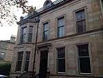
| |||
| 33 Victoria Crescent Road, (Kings Gate) | 55°52′34″N 4°17′53″W / 55.875994°N 4.297962°W | Category B | 32595 |
| |||
| 1 Lancaster Crescent, Gatepiers And Railings, Great Western Road | 55°52′58″N 4°18′09″W / 55.882657°N 4.302609°W | Category B | 32554 |
|
Key
The scheme for classifying buildings in Scotland is:
- Category A: "buildings of national or international importance, either architectural or historic, or fine little-altered examples of some particular period, style or building type."[1]
- Category B: "buildings of regional or more than local importance, or major examples of some particular period, style or building type which may have been altered."[1]
- Category C(S): "buildings of local importance, lesser examples of any period, style, or building type, as originally constructed or moderately altered; and simple traditional buildings which group well with others in categories A and B."[1]
There are approximately 47,400 listed buildings in Scotland. Of these, around 8 per cent (some 3,800) are Category A, and 51 per cent (24,000) are Category B, with the rest listed at Category C(s).[2]
See also
Notes
- ↑ Sometimes known as OSGB36, the grid reference (where provided) is based on the British national grid reference system used by the Ordnance Survey.
• "Guide to National Grid". Ordnance Survey. Retrieved 2007-12-12.
• "Get-a-map". Ordnance Survey. Retrieved 2007-12-17. - ↑ The "HB Number" is a unique number assigned to each listed building by Historic Scotland.
References
- All entries, addresses and coordinates are based on data from Historic Scotland. This data falls under the Open Government Licence
- 1 2 3 "What is Listing?". Historic Scotland. Retrieved 2010-07-06.
- ↑ Guide to the Protection of Scotland’s Listed Buildings (PDF). Historic Scotland. 2009. p. 17. ISBN 978-1-84917-013-0. Retrieved 2010-07-06.
This article is issued from Wikipedia - version of the 11/8/2016. The text is available under the Creative Commons Attribution/Share Alike but additional terms may apply for the media files.