List of listed buildings in Glasgow/7
This is a list of listed buildings in Glasgow, Scotland.
List
| Name | Location | Date Listed | Grid Ref. [note 1] | Geo-coordinates | Notes | HB Number [note 2] | Image |
|---|---|---|---|---|---|---|---|
| 2 Lancaster Crescent, 2 Lancaster Crescent Lane; Great Western Road | 55°52′57″N 4°18′09″W / 55.882598°N 4.302382°W | Category B | 32555 | 
| |||
| 1-3 (Inclusive Nos) Lancaster Terrace And Gatepiers, Great Western Road | 55°52′54″N 4°18′10″W / 55.88172°N 4.302761°W | Category B | 32558 |
| |||
| 14-16 (Even Nos) Mirrlees Drive And 18-20 (Even Nos) Mirrlees Drive | 55°52′56″N 4°17′51″W / 55.882153°N 4.297383°W | Category C(S) | 32569 |
| |||
| 124 Observatory Road, Elmslea | 55°52′42″N 4°17′49″W / 55.878215°N 4.296958°W | Category B | 32570 |
| |||
| 2-8 (Even Nos) Kensington Road And Boundary Walls | 55°52′47″N 4°18′01″W / 55.87978°N 4.300248°W | Category B | 32538 |
| |||
| 2-14 (Even Nos) Dowanside Road | 55°52′30″N 4°17′41″W / 55.874923°N 4.294701°W | Category C(S) | 32501 |
| |||
| 27-29 (Odd Nos) Dundonald Road, St Lukes Greek Orthodox Cathedral | 55°52′45″N 4°17′57″W / 55.879055°N 4.299134°W | Category B | 32508 | 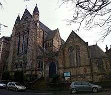
| |||
| 985 Great Western Road (Westbourne House) With 11 Hyndland Road With Retaining Walls | 55°52′56″N 4°18′12″W / 55.882094°N 4.303407°W | Category B | 32516 |
| |||
| 1-9 (Inclusive Nos) Bowmont Terrace | 55°52′37″N 4°17′50″W / 55.876833°N 4.29734°W | Category B | 32481 |
| |||
| Daisy Street Govanhill Church Of Scotland | 55°50′10″N 4°15′31″W / 55.836205°N 4.258737°W | Category B | 32430 |
| |||
| 34 Dixon Avenue, Langside Road, Maxwell Exhibitions Ltd. (Former Crosshill Victoria Church And Hall) | 55°50′05″N 4°15′46″W / 55.834757°N 4.262726°W | Category B | 32431 |
| |||
| 120-142 (Even Nos) Queen's Drive, 538-540 (Even Nos) Victoria Road And 3, 5 Maybank Street Including Railings | 55°50′03″N 4°16′02″W / 55.834088°N 4.267334°W | Category B | 32454 |
| |||
| 170 Queen's Drive And Albert Avenue, Strathbungo Queen's Park Church Including Hall | 55°50′05″N 4°16′10″W / 55.834731°N 4.269511°W | Category B | 32457 |
| |||
| 401-407 (Odd Nos) Victoria Road, Allison Street, Victoria Cross Building | 55°50′11″N 4°15′52″W / 55.836305°N 4.264524°W | Category B | 32459 |
| |||
| Victoria Road Gateway To Queen's Park Including Gatepiers Gates And Railings | 55°50′00″N 4°15′57″W / 55.833385°N 4.265968°W | Category B | 32414 |
| |||
| 84 Albert Road Sunnybank | 55°50′01″N 4°15′41″W / 55.833676°N 4.261401°W | Category B | 32421 |
| |||
| 83 Craigie Street, St Bride's Primary School, Former Strathbungo Public School Including Janitor's Lodge Gatepiers And Railings | 55°50′12″N 4°15′59″W / 55.836576°N 4.266425°W | Category B | 32428 |
| |||
| Battle Place, Battlefield Monument | 55°49′40″N 4°16′14″W / 55.827692°N 4.270554°W | Category B | 32360 | 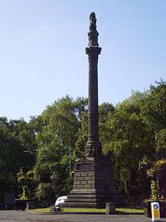
| |||
| 55 Battlefield Road, Grange Road Battlefield Rest | 55°49′38″N 4°15′59″W / 55.827133°N 4.26629°W | Category B | 32361 |
| |||
| 1 Langside Avenue, Langside Hall | 55°49′53″N 4°16′39″W / 55.831472°N 4.277545°W | Category A | 32369 |
| |||
| Millbrae Bridge (Langside Drive - Millbrae Road Over River Cart) | 55°49′20″N 4°16′39″W / 55.822261°N 4.277486°W | Category B | 32383 |
| |||
| 41 Nithsdale Drive, Nithsdale Hall Including Gatepiers | 55°50′16″N 4°16′10″W / 55.837868°N 4.269455°W | Category B | 32390 |
| |||
| 11-69 (Odd Nos) Nithsdale Road | 55°50′11″N 4°16′17″W / 55.836458°N 4.271337°W | Category B | 32393 |
| |||
| 40-46 (Even Nos) Nithsdale Street | 55°50′15″N 4°16′16″W / 55.837496°N 4.27111°W | Category C(S) | 32396 |
| |||
| 64 Randolph Road, Marlborough Avenue, 4 Rowallan Lane, Broomhill Church And Halls (Church Of Scotland) | 55°52′41″N 4°19′14″W / 55.878079°N 4.320468°W | Category C(S) | 32296 |
| |||
| 3 And 5 Arnwood Drive (Westwood And St Brendan) | 55°53′08″N 4°19′03″W / 55.885426°N 4.317389°W | Category B | 32300 |
| |||
| 45 Chamberlain Road, Jordanhill Training College Demonstration School, Lodge, Gates, Gatepiers And Quadrant Walls | 55°53′06″N 4°20′01″W / 55.88501°N 4.333707°W | Category B | 32303 |
| |||
| 50 Cleveden Drive Boundary Walls And Gatepiers | 55°53′02″N 4°18′16″W / 55.883918°N 4.304411°W | Category B | 32307 |
| |||
| 52 Cleveden Drive, Boundary Walls And Gatepiers | 55°53′03″N 4°18′18″W / 55.884095°N 4.305013°W | Category B | 32308 |
| |||
| 56 Cleveden Drive "Westmount", Boundary Walls And Gatepiers | 55°53′04″N 4°18′21″W / 55.884419°N 4.305959°W | Category B | 32310 |
| |||
| 1055 Great Western Road, Gartnavel Royal Hospital Chapel | 55°53′02″N 4°19′01″W / 55.883925°N 4.316932°W | Category B | 32320 |
| |||
| 1105 Great Western Road, 9 Whittingehame Gardens | 55°53′13″N 4°19′03″W / 55.886863°N 4.317459°W | Category C(S) | 32330 |
| |||
| 1107 Great Western Road, 10 Whittingehame Gardens | 55°53′13″N 4°19′04″W / 55.886956°N 4.3178°W | Category C(S) | 32331 |
| |||
| 998 Great Western Road, St Mungos Academy Centenary Club, Garage, Service Block, Gatepiers And Retaining Walls | 55°53′01″N 4°18′17″W / 55.883571°N 4.304694°W | Category A | 32334 |
| |||
| 9 Winton Drive, Winton Lodge And Gatepiers | 55°53′09″N 4°18′08″W / 55.8857°N 4.302342°W | Category B | 32343 |
| |||
| 28 Woodend Drive Jordanhill Parish Church, Church Of Scotland | 55°53′07″N 4°19′45″W / 55.885404°N 4.329077°W | Category B | 32347 |
| |||
| 24 Gairbraid Avenue, Former Police Station | 55°53′26″N 4°17′28″W / 55.890679°N 4.291249°W | Category B | 32350 |
| |||
| 21 Jardine Street, Lanarkshire Regiment Drill Hall | 55°52′37″N 4°16′38″W / 55.877072°N 4.277242°W | Category B | 32272 |
| |||
| 739 South Street, Former North British Diesel Engine Engine Works, Quayside Titan Crane | 55°52′21″N 4°20′44″W / 55.872382°N 4.345546°W | Category A | 32281 |
| |||
| 2 Broomhill Avenue And 1-3 (Odd Nos) Broomhill Terrace | 55°52′22″N 4°19′27″W / 55.872697°N 4.324224°W | Category C(S) | 32288 |
| |||
| 63, 65, 69, 71, 73, 77, 79, 81, 83, 85, 87, 89 St George's Road And 10, 14, 18, 20, 24 28 Woodlands Road | 55°52′04″N 4°16′17″W / 55.867804°N 4.271505°W | Category B | 32249 |
| |||
| Lynedoch Place/Park Circus Place; Park Church Tower | 55°52′07″N 4°16′37″W / 55.86854°N 4.276886°W | Category B | 32223 |
| |||
| 21-25 (Odd Nos) Glasgow Street | 55°52′29″N 4°17′02″W / 55.874592°N 4.283955°W | Category B | 32193 |
| |||
| Kelvingrove Park, Roberts Memorial | 55°52′13″N 4°16′55″W / 55.870308°N 4.281865°W | Category A | 32211 | 
| |||
| Kelvinway Paired Gatepiers To Kelvinway At University Avenue And Sauchiehall Street | 55°52′01″N 4°17′19″W / 55.86693°N 4.288604°W | Category C(S) | 32214 |
| |||
| 753 And 755 Westerhouse Road, St Benedict's Roman Catholic Church And Presbytery | 55°52′10″N 4°07′08″W / 55.869574°N 4.118913°W | Category B | 32159 |
| |||
| 10, 14-32 (Even Nos) Queen Mary Avenue, Speirs Place | 55°49′59″N 4°15′45″W / 55.832997°N 4.262623°W | Category B | 32172 |
| |||
| 118 And 126-136 (Even Nos) Stanley Street, Former Our Lady And St Margaret's Presbytery And Primary School (Roman Catholic) Including Gatepiers, Gates, Railings And Boundary Wall | 55°51′03″N 4°16′50″W / 55.850828°N 4.280627°W | Category C(S) | 46279 |
| |||
| 316 Caledonia Road, Rutherglen Road, Southern Necropolis Cemetery And Boundary Walls | 55°50′37″N 4°14′49″W / 55.843529°N 4.247038°W | Category B | 47416 |
| |||
| 197 Crookston Road, Ross Hall Park, Grotto, Rock Garden, Passage, Retaining Wall, Boat House And Ornamental Paths | 55°50′19″N 4°21′48″W / 55.838589°N 4.363379°W | Category B | 48282 |
| |||
| 39-45 (Odd Nos) Washington Street, Royal Scottish Pipe Band Association Headquarters And College | 55°51′29″N 4°16′06″W / 55.858155°N 4.268353°W | Category C(S) | 48631 |
| |||
| 5 And 7 Horselethill Road, Horselethill House With Conservatory | 55°52′43″N 4°17′49″W / 55.878693°N 4.29689°W | Category C(S) | 48683 |
| |||
| 36-40 Golspie Street & 16 Garmouth Street, Salvation Army Citadel | 55°51′47″N 4°19′04″W / 55.862942°N 4.317711°W | Category B | 49789 |
| |||
| 93 Saracen Street, Former Askit Laboratory And Manufactory Including Boundary Wall | 55°52′50″N 4°15′17″W / 55.88047°N 4.254753°W | Category B | 49923 |
| |||
| 243 Centre Street, Former Telephone Exchange | 55°51′04″N 4°15′44″W / 55.851248°N 4.262278°W | Category B | 49932 |
| |||
| 74 Victoria Crescent Road, Former Dowanside House And Former Notre Dame Training College Wing To East Including Gatepiers, Railings And Boundary Walls | 55°52′39″N 4°17′57″W / 55.877598°N 4.299224°W | Category C(S) | 50027 |
| |||
| 242 Castlemilk Road, King's Park Church Including Gates And Railings | 55°49′14″N 4°14′04″W / 55.82048°N 4.23447°W | Category B | 50119 |
| |||
| 30 Havelock Street, Dowanhill Primary School, Including Boundary Walls And Gatepiers | 55°52′27″N 4°17′55″W / 55.874138°N 4.298731°W | Category C(S) | 50273 |
| |||
| Partick Bridge Over River Kelvin | 55°52′11″N 4°17′39″W / 55.869628°N 4.294277°W | Category B | 50583 |
| |||
| Albert Drive, Edward Viii Pillar Box | 55°50′33″N 4°16′30″W / 55.842612°N 4.274922°W | Category B | 50819 |
| |||
| Cathedral Square, Police Box | 55°51′44″N 4°14′11″W / 55.8621°N 4.236476°W | Category B | 51059 | 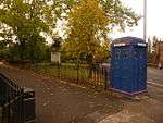
| |||
| 7 Broompark Circus, Broompark Day Nursery Including Boundary Walls And Gatepiers | 55°51′44″N 4°13′22″W / 55.862313°N 4.222777°W | Category C(S) | 51444 |
| |||
| 12 Washington Street, Former Washington Street Public School With Boundary Walls, Gatepiers, Steps And Railings | 55°51′32″N 4°16′09″W / 55.85902°N 4.269218°W | Category C(S) | 45642 |
| |||
| 176-178 (Even Nos) Bath Street | 55°51′53″N 4°15′42″W / 55.864677°N 4.261701°W | Category C(S) | 44597 |
| |||
| 52 Speirs Wharf, Wheatsheaf Building | 55°52′28″N 4°15′26″W / 55.8745°N 4.2573°W | Category C(S) | 44112 |
| |||
| 5 And 7 Wellington Street And 306-314 (Even Nos) Argyle Street | 55°51′32″N 4°15′41″W / 55.859012°N 4.261387°W | Category C(S) | 43902 |
| |||
| Great Western Road, Anniesland Station Bridge | 55°53′20″N 4°19′20″W / 55.889012°N 4.322208°W | Category B | 43373 | 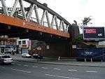
| |||
| 55 Crescent Road, Dunronald With Gate, Railings And Gatepiers | 55°53′13″N 4°21′26″W / 55.886842°N 4.357357°W | Category B | 43115 |
| |||
| 12 Dunterlie Avenue, Knightswood Congregational Church And Hall With Railings And Gates | 55°53′24″N 4°21′28″W / 55.890079°N 4.357777°W | Category B | 43116 |
| |||
| 215 Kinfauns Drive, St Laurence (Martyr) Roman Catholic Church And Presbytery With Boundary Wall, Gates, Gatepiers And Railings | 55°54′53″N 4°22′30″W / 55.914642°N 4.375079°W | Category B | 43029 |
| |||
| 29 Newlands Road, 8 Lubnaig Road, Carradale | 55°49′14″N 4°16′52″W / 55.820657°N 4.281144°W | Category B | 33946 |
| |||
| 14, 16 St Bride`S Road | 55°49′18″N 4°17′07″W / 55.821746°N 4.285374°W | Category B | 33962 |
| |||
| 223 Shawbridge Street, Pollokshaws Parish Church | 55°49′18″N 4°17′59″W / 55.821668°N 4.299722°W | Category B | 33964 | 
| |||
| 6 Onslow Drive, Day Nursery | 55°51′41″N 4°13′14″W / 55.861497°N 4.220669°W | Category C(S) | 33903 |
| |||
| 2 Auldhouse Court, Thornliebank Road | 55°48′59″N 4°18′14″W / 55.81642°N 4.303962°W | Category B | 33913 |
| |||
| Ellangowan Road And Haggs Road, Electricity Substation Including Gatepiers And Boundary Wall | 55°49′43″N 4°17′43″W / 55.828691°N 4.295155°W | Category B | 33922 |
| |||
| 351-355 (Odd Nos) Kilmarnock Road And Newlands Road, St Margaret`S Episcopal Church And Halls, Including Gates And Railings | 55°49′18″N 4°17′11″W / 55.821549°N 4.286321°W | Category B | 33926 | 
| |||
| 26 Langside Avenue And 1041-1043 (Odd Nos) Pollokshaws Road, Marlborough House Including Maxwells | 55°49′52″N 4°16′44″W / 55.831153°N 4.278772°W | Category C(S) | 33928 |
| |||
| Glasgow Green, Saltmarket Maclennan Arch | 55°51′12″N 4°14′45″W / 55.853357°N 4.245784°W | Category B | 33841 | 
| |||
| 14 Monteith Row, Monteith Hotel | 55°51′12″N 4°14′15″W / 55.853299°N 4.237616°W | Category B | 33854 |
| |||
| 18 And 20 Castlefield Court | 55°53′03″N 4°10′00″W / 55.884256°N 4.166579°W | Category B | 33866 |
| |||
| Gartloch Road, Gartloch Hospital, West Lodge | 55°52′54″N 4°06′33″W / 55.881728°N 4.109278°W | Category B | 33871 |
| |||
| Gartloch Road, Gartloch Hospital, New Nurses Home | 55°52′40″N 4°06′39″W / 55.877748°N 4.110789°W | Category B | 33872 |
| |||
| 1019-1041 (Odd Nos) Cathcart Road And 3 Stanmore Road | 55°49′39″N 4°15′32″W / 55.827456°N 4.258964°W | Category C(S) | 33799 |
| |||
| 1123 Cathcart Road, Hampden Drive, Mount Florida Parish Church Including Railings | 55°49′33″N 4°15′24″W / 55.825699°N 4.256787°W | Category B | 33800 |
| |||
| 2-26 (Even Nos) Dalmarnock Road And 1-11 (Odd Nos) Main Street Bridgeton, Bridgeton Cross Mansions | 55°50′54″N 4°13′34″W / 55.848251°N 4.226079°W | Category C(S) | 33826 |
| |||
| Glasgow Green, Boathouse Nearest Weir And Pipe Bridge | 55°51′07″N 4°14′38″W / 55.851853°N 4.243956°W | Category B | 33834 |
| |||
| 520 Bilsland Drive, Ruchill Hospital, Water Tower | 55°53′13″N 4°15′57″W / 55.886891°N 4.26576°W | Category A | 33750 |
| |||
| 1-6 (Inclusive Nos) Doune Quadrant | 55°52′43″N 4°16′55″W / 55.878495°N 4.28193°W | Category C(S) | 33760 |
| |||
| 251-261 (Odd Nos) Garrioch Road | 55°52′57″N 4°17′18″W / 55.882502°N 4.288257°W | Category B | 33761 |
| |||
| 14 Kelvin Drive And Gatepiers | 55°52′50″N 4°17′15″W / 55.88046°N 4.287401°W | Category B | 33769 |
| |||
| 9 Kelvinside Gardens, St Charles Rc Church | 55°52′45″N 4°16′37″W / 55.879277°N 4.277067°W | Category B | 33771 |
| |||
| 2 Kelvinside Terrace West And 301 Wilton Street With Retaining Walls | 55°52′46″N 4°17′02″W / 55.879499°N 4.284003°W | Category B | 33773 |
| |||
| 405, 407 Cumberland Street, St Francis Church And Presbytery | 55°50′47″N 4°14′45″W / 55.846429°N 4.245704°W | Category A | 33690 |
| |||
| 119 Carmunnock Road, Cathcart Old Parish Church Including Session House, Gates, Gatepiers And Boundary Walls | 55°49′05″N 4°15′15″W / 55.818137°N 4.254034°W | Category B | 33707 | 
| |||
| 1035 Balmore Road, Lambhill Cemetery, Entrance Arch, Railings And Gates | 55°54′09″N 4°16′10″W / 55.902499°N 4.269342°W | Category B | 33728 |
| |||
| 2064 Maryhill Road | 55°53′58″N 4°18′05″W / 55.899471°N 4.30127°W | Category B | 33733 |
| |||
| London Road, Belvidere Hospital, Nurses' Home/Administration Block | 55°50′42″N 4°12′02″W / 55.844982°N 4.200462°W | Category B | 33638 |
| |||
| 1147 And 1167 London Road, London Road School Including Lodge, Boundary Walls And Gatepiers | 55°50′54″N 4°12′24″W / 55.848293°N 4.206752°W | Category B | 33639 |
| |||
| 1169 Shettleston Road, Portland Arms Public House | 55°51′06″N 4°09′55″W / 55.851733°N 4.165408°W | Category B | 33645 |
| |||
| 591 Tollcross Road, Tollcross House, Tollcross Park | 55°50′47″N 4°10′47″W / 55.84633°N 4.179787°W | Category A | 33648 |
| |||
| 591 Tollcross Road, Tollcross House Conservatory, Tollcross Park | 55°50′51″N 4°10′45″W / 55.847365°N 4.179206°W | Category B | 33650 |
| |||
| 155 Carmyle Avenue, Carmyle Church And Gatepiers, Boundary Walls And Railings | 55°49′51″N 4°09′29″W / 55.830806°N 4.158032°W | Category B | 33661 |
| |||
| 315 And 315A Hamilton Road, Boghall Steading | 55°50′26″N 4°07′28″W / 55.840522°N 4.124407°W | Category C(S) | 33669 |
| |||
| 102-106 (Even Nos) Main Street, Church Street, Baillieston | 55°51′01″N 4°06′37″W / 55.85023°N 4.110207°W | Category C(S) | 33673 |
| |||
| 15 Swinton Road, St Bridget's Roman Catholic Church And Presbytery, Boundary Walls, Gates And Railings | 55°51′09″N 4°06′36″W / 55.852596°N 4.110112°W | Category B | 33679 |
| |||
| 161 Crookston Road, Former Stable Block To Ross Hall | 55°50′28″N 4°21′50″W / 55.840989°N 4.363828°W | Category C(S) | 33590 |
| |||
| 510 Crookston Road, Leverndale Hospital, Gate Lodge | 55°50′06″N 4°21′51″W / 55.83513°N 4.364223°W | Category C(S) | 33594 |
| |||
| 21 Lochmaben Road, Former Crookston Station And Stationmaster's Cottage | 55°50′33″N 4°21′52″W / 55.842512°N 4.364559°W | Category B | 33600 | 
| |||
| 7 Keppochill Road, Keppochhill Court, Blocks A And B, Former Springburn Fire Station With Elevation To Springburn Road | 55°52′47″N 4°14′04″W / 55.879814°N 4.234553°W | Category B | 33615 |
| |||
| 2 Speirs Wharf, Canal House | 55°52′18″N 4°15′27″W / 55.87174°N 4.257364°W | Category B | 33618 |
| |||
| 247-255 (Odd Nos) Springburn Way (Formerly 563-567 (Odd Nos) Springburn Road), And 30 Hillkirk Street Lane, Trustee Savings Bank Building | 55°53′00″N 4°13′46″W / 55.883374°N 4.229529°W | Category B | 33625 |
| |||
| 225 Scotland Street, Scotland Street School, With Janitor's House And Railings | 55°50′58″N 4°16′25″W / 55.849438°N 4.273692°W | Category A | 33534 | 
| |||
| 2-6 Scotland Street (Even Nos), 220-228 West Street (Even Nos) And 65-75 Paterson Street (Odd Nos) | 55°51′00″N 4°16′01″W / 55.849996°N 4.266823°W | Category B | 33535 |
| |||
| 3 Sydenham Road, Including Mews Cottage | 55°52′42″N 4°18′09″W / 55.878445°N 4.302471°W | Category B | 33544 |
| |||
| 6 Rowan Road Craigie Hall, Dumbreck | 55°50′49″N 4°18′32″W / 55.846932°N 4.308818°W | Category A | 33583 |
| |||
| 50 St Andrew's Drive, Glenafton Nursing Home, Including Boundary Walls And Gatepiers | 55°50′43″N 4°17′16″W / 55.845231°N 4.287791°W | Category B | 33466 |
| |||
| 620 Shields Road, Nithsdale Lodge, Former Pollokshields West Church Including Boundary Wall And Gatepiers | 55°50′26″N 4°16′40″W / 55.840608°N 4.277824°W | Category B | 33482 |
| |||
| 99 Springkell Avenue, Including Boundary Walls And Gatepiers | 55°50′21″N 4°17′53″W / 55.83926°N 4.298093°W | Category B | 33483 |
| |||
| 129 Abbotsford Place And Pollokshaws Road, School And Janitor's House | 55°50′47″N 4°15′32″W / 55.846323°N 4.258829°W | Category B | 33490 |
| |||
| 339 Eglinton Street And Devon Street, Former Eglinton Congregational Church | 55°50′47″N 4°15′39″W / 55.846421°N 4.260832°W | Category B | 33509 |
| |||
| 63 Fotheringay Road, United Reformed Church, Former Pollokshields Congregational Church And Hall | 55°50′14″N 4°17′01″W / 55.837156°N 4.283643°W | Category C(S) | 33406 |
| |||
| 30 Leslie Street And Kenmure Street, Pollokshields District Library | 55°50′28″N 4°16′22″W / 55.841104°N 4.272854°W | Category B | 33419 |
| |||
| 8 Matilda Road, Including Boundary Walls And Gatepiers | 55°50′40″N 4°17′05″W / 55.844486°N 4.28484°W | Category B | 33422 |
| |||
| 37, 37A Newark Drive, Including Boundary Walls And Gatepiers | 55°50′24″N 4°17′00″W / 55.840009°N 4.283443°W | Category B | 33431 |
| |||
| 39 Newark Drive, Including Boundary Walls And Gatepiers | 55°50′25″N 4°17′02″W / 55.84018°N 4.283901°W | Category B | 33432 |
| |||
| 202 Nithsdale Road, Castlehill, Including Boundary Walls And Gatepiers | 55°50′32″N 4°17′13″W / 55.842226°N 4.287007°W | Category A | 33451 |
| |||
| 514 And 516 Pollokshaws Road And 1 Albert Drive, St Ninian's Episcopal Church Including Hall | 55°50′27″N 4°16′00″W / 55.840733°N 4.266667°W | Category B | 33454 | 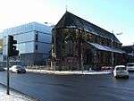
| |||
| 55 St Andrews Drive Including Gatepiers, Boundary Walls And Gates | 55°50′42″N 4°17′12″W / 55.844945°N 4.286736°W | Category B | 33461 |
| |||
| Kittoch Bridge, B759 Over Kittoch Water | 55°47′06″N 4°15′03″W / 55.784899°N 4.25071°W | Category C(S) | 33332 |
| |||
| Linn Park, Iron Bridge | 55°48′20″N 4°15′56″W / 55.805565°N 4.265675°W | Category B | 33333 |
| |||
| 18 Clydebrae Street, Govan Graving Docks | 55°51′39″N 4°18′03″W / 55.860804°N 4.300916°W | Category A | 33336 |
| |||
| 577-581 Govan Road, Former Govan Press Buildings | 55°51′37″N 4°18′13″W / 55.860186°N 4.303692°W | Category B | 33341 |
| |||
| Near 801 Govan Road, Junction With Burleigh Street, Sir William Pearce, Statue | 55°51′48″N 4°18′46″W / 55.863311°N 4.312907°W | Category B | 33343 | 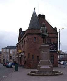
| |||
| 816, 818 Govan Road, 1, 3 Water Row, Former British Linen Bank, And Flats | 55°51′48″N 4°18′42″W / 55.863308°N 4.311644°W | Category A | 33351 |
| |||
| 100-132 (Even Nos) Albert Drive And Darnley Street | 55°50′30″N 4°16′11″W / 55.841791°N 4.269731°W | Category B | 33375 |
| |||
| 330 And 330A Albert Drive, Including Boundary Walls And Gatepiers | 55°50′39″N 4°17′06″W / 55.844294°N 4.285004°W | Category B | 33380 |
| |||
| 110 West George Street | 55°51′45″N 4°15′21″W / 55.862394°N 4.255847°W | Category B | 33237 |
| |||
| 144, 146 West George Street, Cornhill House | 55°51′46″N 4°15′26″W / 55.862665°N 4.257253°W | Category A | 33241 |
| |||
| 110-126 (Even Nos) West Nile Street And 17, 19 Bath Street | 55°51′48″N 4°15′15″W / 55.863231°N 4.254281°W | Category C(S) | 33255 |
| |||
| 79 West Regent Street And 183-191 (Odd Nos) Hope Street | 55°51′47″N 4°15′29″W / 55.863053°N 4.258106°W | Category B | 33258 |
| |||
| 91, 93 West Regent Street | 55°51′47″N 4°15′31″W / 55.863171°N 4.258545°W | Category C(S) | 33261 |
| |||
| 172-186 (Even Nos) West Regent Street | 55°51′50″N 4°15′42″W / 55.86393°N 4.261737°W | Category B | 33279 |
| |||
| 74 York Street And 55-61 (Odd Nos) Robertson Lane | 55°51′30″N 4°15′44″W / 55.858285°N 4.262288°W | Category B | 33284 |
| |||
| 166 Broomfield Road, Immaculate Heart Of Mary, Rc Church | 55°53′14″N 4°13′29″W / 55.887215°N 4.22484°W | Category B | 33294 |
| |||
| Elder Park, Cottage | 55°51′49″N 4°19′37″W / 55.863695°N 4.326898°W | Category B | 33302 |
| |||
| Elder Park, Statue Of John Elder | 55°51′46″N 4°19′19″W / 55.86278°N 4.322033°W | Category B | 33305 | 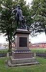
| |||
| 1345 Govan Road, Southern General Hospital | 55°51′47″N 4°20′15″W / 55.863163°N 4.337414°W | Category B | 33307 |
| |||
| 336-356 (Even Nos) Sauchiehall Street And 1 Scott Street | 55°51′57″N 4°15′54″W / 55.865784°N 4.265057°W | Category A | 33193 |
| |||
| 396-450A (Even Nos) Sauchiehall Street, And 2 Garnet Street | 55°51′58″N 4°16′00″W / 55.866041°N 4.266703°W | Category B | 33194 | _SAUCHIEHALL_STREET%2C_AND_2_GARNET_STREET%2C_Glasgow_LB33194.jpg)
|
Key
The scheme for classifying buildings in Scotland is:
- Category A: "buildings of national or international importance, either architectural or historic, or fine little-altered examples of some particular period, style or building type."[1]
- Category B: "buildings of regional or more than local importance, or major examples of some particular period, style or building type which may have been altered."[1]
- Category C(S): "buildings of local importance, lesser examples of any period, style, or building type, as originally constructed or moderately altered; and simple traditional buildings which group well with others in categories A and B."[1]
There are approximately 47,400 listed buildings in Scotland. Of these, around 8 per cent (some 3,800) are Category A, and 51 per cent (24,000) are Category B, with the rest listed at Category C(s).[2]
See also
Notes
- ↑ Sometimes known as OSGB36, the grid reference (where provided) is based on the British national grid reference system used by the Ordnance Survey.
• "Guide to National Grid". Ordnance Survey. Retrieved 2007-12-12.
• "Get-a-map". Ordnance Survey. Retrieved 2007-12-17. - ↑ The "HB Number" is a unique number assigned to each listed building by Historic Scotland.
References
- All entries, addresses and coordinates are based on data from Historic Scotland. This data falls under the Open Government Licence
- 1 2 3 "What is Listing?". Historic Scotland. Retrieved 2010-07-06.
- ↑ Guide to the Protection of Scotland’s Listed Buildings (PDF). Historic Scotland. 2009. p. 17. ISBN 978-1-84917-013-0. Retrieved 2010-07-06.
This article is issued from Wikipedia - version of the 11/7/2016. The text is available under the Creative Commons Attribution/Share Alike but additional terms may apply for the media files.