List of listed buildings in Glasgow/9
This is a list of listed buildings in Glasgow, Scotland.
List
| Name | Location | Date Listed | Grid Ref. [note 1] | Geo-coordinates | Notes | HB Number [note 2] | Image |
|---|---|---|---|---|---|---|---|
| 4-7 (Odd Nos) Chalmers Gate (Formerly 394 Gallowgate) | 55°51′20″N 4°13′57″W / 55.85563°N 4.232509°W | Category B | 33823 | 
| |||
| 71A, 73-77 (Odd Nos) Clouston Street And Railings | 55°52′55″N 4°17′21″W / 55.881947°N 4.289136°W | Category C(S) | 33757 |
| |||
| 275-277 (Odd Nos) Garrioch Road And 72, 74, 76 Clouston Street With Railings And Gatepiers | 55°52′56″N 4°17′20″W / 55.882188°N 4.28875°W | Category C(S) | 33763 |
| |||
| 485 St George's Road, Former St George In The Fields | 55°52′27″N 4°15′50″W / 55.874101°N 4.263847°W | Category A | 33782 | .jpg)
| |||
| 35 Cuthbertson Street And Coplaw Street, Cuthbertson Primary School Including Janitors Lodge, Playground Walls And Gatepiers | 55°50′22″N 4°15′52″W / 55.839515°N 4.264487°W | Category B | 33691 |
| |||
| Adelphi Street/Glasgow Green, St Andrews Suspension Bridge | 55°50′56″N 4°14′18″W / 55.848827°N 4.238398°W | Category A | 33692 | 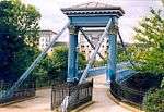
| |||
| 170 Langside Road, Calder Street Govanhill Library | 55°50′16″N 4°15′42″W / 55.837733°N 4.261685°W | Category B | 33695 | 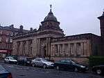
| |||
| Richmond Park, Footbridge Over Polmadie Burn, (Opposite Queensferry Street) | 55°50′19″N 4°13′55″W / 55.838707°N 4.232002°W | Category C(S) | 33699 |
| |||
| 201 Ardencraig Road, Castlemilk, St Martin's Roman Catholic Church And Presbytery | 55°48′05″N 4°13′13″W / 55.801416°N 4.220198°W | Category B | 33701 |
| |||
| 325 Carmunnock Road, King's Park, Aikenhead House, Gatepiers On Main Drive | 55°48′58″N 4°14′46″W / 55.816052°N 4.24614°W | Category B | 33709 |
| |||
| 325 Carmunnock Road, King's Park, Aikenhead House Stable Block | 55°48′45″N 4°14′34″W / 55.81252°N 4.242713°W | Category B | 33711 |
| |||
| Machrie Road, Barlia Terrace, Castlemilk House Bridge | 55°48′29″N 4°13′14″W / 55.808124°N 4.220468°W | Category B | 33721 |
| |||
| 100 Acre Road, Acre House With Boundary Walls And Gatepiers | 55°54′14″N 4°18′24″W / 55.903791°N 4.306709°W | Category C(S) | 33727 |
| |||
| Maryhill Road, Martyrs Memorial Pillar | 55°53′50″N 4°17′58″W / 55.897095°N 4.29953°W | Category C(S) | 33732 |
| |||
| Bilsland Drive Aqueduct | 55°53′05″N 4°16′45″W / 55.884586°N 4.279153°W | Category B | 33745 |
| |||
| 14 Orr Street, Olympia Street, County Bingo | 55°50′58″N 4°13′34″W / 55.849489°N 4.226214°W | Category B | 33642 |
| |||
| 179 Shettleston Road, Including Gates And Railings, Employment Exchange | 55°51′17″N 4°11′48″W / 55.854812°N 4.19656°W | Category B | 33643 |
| |||
| 316 Caledonia Road, Rutherglen Road, Southern Necropolis Lodge | 55°50′38″N 4°14′43″W / 55.843974°N 4.245275°W | Category A | 33685 |
| |||
| 500 Corselet Road, Darnley Mill | 55°48′27″N 4°19′57″W / 55.807436°N 4.332364°W | Category B | 33589 |
| |||
| 510 Crookston Road, Leverndale Hospital, Towerview Unit | 55°50′04″N 4°22′14″W / 55.834574°N 4.370689°W | Category A | 33597 |
| |||
| Ralston Avenue 109 (Westfield) And 113 (Auldersyde) Including Boundary Walls And Gatepiers | 55°50′31″N 4°22′10″W / 55.841886°N 4.369505°W | Category B | 33606 |
| |||
| Salterland Road, Bridge At Salterland | 55°48′45″N 4°22′30″W / 55.812572°N 4.374889°W | Category C(S) | 33607 |
| |||
| 104 Elmvale Street, 712 Hawthorn Street, Elmvale Primary School Including Janitor's Lodge And Playground Walls | 55°53′10″N 4°14′02″W / 55.885982°N 4.233885°W | Category B | 33611 |
| |||
| 110-136 (Even Nos) Flemington Street, Former Springburn College Including Range To East | 55°52′47″N 4°13′50″W / 55.879745°N 4.230424°W | Category A | 33612 |
| |||
| 48, 54 Gourlay Street, Springburn Nursery School, Former Springburn Primary School | 55°52′51″N 4°14′07″W / 55.880702°N 4.235148°W | Category C(S) | 33613 |
| |||
| 6, 10 Hillkirk Street St Aloysius Rc Church And Presbytery | 55°53′00″N 4°13′47″W / 55.883252°N 4.229794°W | Category B | 33614 |
| |||
| 1448-1456 (Even Nos) Gallowgate And Burgher Street | 55°51′04″N 4°11′51″W / 55.851038°N 4.197497°W | Category B | 33634 |
| |||
| 8, 10 Haugh Road And 9 Overnewton Street, St Vincent Masonic Halls | 55°51′58″N 4°17′24″W / 55.866022°N 4.290069°W | Category C(S) | 33545 |
| |||
| 5 Sydenham Road Including Gatepiers And Coachhouse | 55°52′41″N 4°18′07″W / 55.878138°N 4.30207°W | Category B | 33547 |
| |||
| Lainshaw Drive, Linn Crematorium Including Canopies, Gatepiers, Railings And Lodges | 55°48′02″N 4°15′43″W / 55.800535°N 4.262064°W | Category B | 33549 |
| |||
| 995 Paisley Road West, Lodge To Bellahouston Park | 55°50′55″N 4°19′02″W / 55.848474°N 4.317169°W | Category C(S) | 33578 |
| |||
| 520-532 (Even Nos) Paisley Road West, 8 Ibroxholm Place, 33 Ibroxholm Avenue | 55°51′03″N 4°18′16″W / 55.850854°N 4.304338°W | Category B | 33581 |
| |||
| 20 Corkerhill Gardens, Maryland House | 55°50′45″N 4°19′57″W / 55.845777°N 4.332393°W | Category C(S) | 33588 |
| |||
| 32 St Andrews Drive | 55°50′48″N 4°16′52″W / 55.846711°N 4.281185°W | Category B | 33465 |
| |||
| 11 Sherbrooke Avenue And Nithsdale Road, Sherbrooke Hotel, Including Boundary Walls, Railings And Gatepiers | 55°50′35″N 4°17′50″W / 55.843187°N 4.297127°W | Category B | 33468 |
| |||
| 34 Sherbrooke Avenue Cairn O'Mount, Including Gatepiers And Boundary Walls | 55°50′28″N 4°18′00″W / 55.841131°N 4.299897°W | Category B | 33475 |
| |||
| 30, 30A Sutherland Avenue, Ardtornish, Including Boundary Walls And Gatepiers | 55°50′27″N 4°17′52″W / 55.840847°N 4.297788°W | Category B | 33487 |
| |||
| 1, 3 Bridge Street And 87 Carlton Place | 55°51′16″N 4°15′29″W / 55.8545°N 4.257962°W | Category B | 33492 |
| |||
| Govan Road And Paisley Road Junction, Piazza At North Side, Toll Gate Pier | 55°51′14″N 4°16′45″W / 55.853922°N 4.279083°W | Category B | 33514 |
| |||
| 56-64 Kingston Street And Return Elevation To Centre Street | 55°51′15″N 4°15′43″W / 55.854247°N 4.261973°W | Category B | 33516 |
| |||
| 27 Newark Drive, Including Boundary Walls, Gatepiers And Gates | 55°50′23″N 4°16′54″W / 55.839657°N 4.281586°W | Category B | 33429 |
| |||
| 16 Newark Drive, Including Boundary Walls And Gatepiers | 55°50′24″N 4°16′46″W / 55.840004°N 4.279338°W | Category B | 33436 |
| |||
| 193 Nithsdale Road, Including Boundary Walls And Gatepiers | 55°50′29″N 4°17′07″W / 55.84127°N 4.28521°W | Category B | 33439 |
| |||
| 195 Nithsdale Road, Including Boundary Walls And Gatepiers | 55°50′29″N 4°17′08″W / 55.84127°N 4.28569°W | Category C(S) | 33440 |
| |||
| 174 Nithsdale Road, Ashbank, Including Boundary Walls And Gatepiers | 55°50′29″N 4°16′48″W / 55.841457°N 4.279998°W | Category C(S) | 33446 |
| |||
| 200 Nithsdale Road, Ellisland, Including Boundary Walls And Gatepiers | 55°50′32″N 4°17′11″W / 55.842105°N 4.286266°W | Category A | 33450 |
| |||
| 2060 Pollokshaws Road, Pollok House Former Stables, Including Courtyard Ranges | 55°49′35″N 4°18′59″W / 55.826352°N 4.31638°W | Category A | 33457 |
| |||
| 2060 Pollokshaws Road, Pollok House, Shawmuir Lodge On Pollok Avenue, Including Gates And Gatepiers | 55°49′36″N 4°18′03″W / 55.826591°N 4.300763°W | Category B | 33459 |
| |||
| 2060 Pollokshaws Road, Pollok House Walled Gardens, Including Drybridge | 55°49′38″N 4°18′56″W / 55.827185°N 4.315568°W | Category B | 33460 |
| |||
| 61 St Andrew's Drive, 46 Aytoun Road, Doralee, Including Boundary Walls And Gatepiers | 55°50′37″N 4°17′17″W / 55.843654°N 4.288034°W | Category B | 33463 |
| |||
| 65 St Andrews Drive, Including Boundary Walls And Gatepiers | 55°50′30″N 4°17′20″W / 55.841587°N 4.288967°W | Category B | 33464 |
| |||
| Carmunnock, 107 Waterside Road, (2-Storey Range Only) | 55°47′29″N 4°14′08″W / 55.791343°N 4.235417°W | Category C(S) | 33329 |
| |||
| 831 Govan Road, St Anthony's Rc Church | 55°51′48″N 4°18′52″W / 55.863425°N 4.314496°W | Category B | 33345 |
| |||
| 908 Govan Road And Return Elevation To Mckechnie Street, County Bingo Social Club, Former Lyceum Cinema | 55°51′51″N 4°18′55″W / 55.864303°N 4.315155°W | Category B | 33355 |
| |||
| 1030, 1048 Govan Road, Govan Shipbuilders Ltd, General Offices (Excluding 1956 Extension To W) | 55°51′56″N 4°19′25″W / 55.86542°N 4.323597°W | Category A | 33356 |
| |||
| 137-143 (Odd Nos) Albert Drive And 100, 102 Forth Street | 55°50′29″N 4°16′16″W / 55.841524°N 4.271057°W | Category B | 33366 |
| |||
| 165-193 (Odd Nos) Albert Drive, 159 Kenmure Street And 50-54 (Even Nos) Glenapp Street | 55°50′31″N 4°16′21″W / 55.841918°N 4.272582°W | Category B | 33368 |
| |||
| 328 Albert Drive, Craigholme School Infant Department, Including Gatepiers And Boundary Walls | 55°50′39″N 4°17′02″W / 55.844073°N 4.283841°W | Category B | 33379 |
| |||
| 354 Albert Drive, Including Boundary Walls And Gatepiers | 55°50′41″N 4°17′30″W / 55.844698°N 4.291769°W | Category B | 33384 |
| |||
| 48 And 48A Dalziel Drive, Including Boundary Walls And Gatepiers | 55°50′32″N 4°17′36″W / 55.842145°N 4.29328°W | Category B | 33399 |
| |||
| 58, 58A Dalziel Drive, Including Boundary Walls And Gatepiers | 55°50′34″N 4°17′47″W / 55.842689°N 4.296363°W | Category B | 33400 |
| |||
| Darnley Road/Moray Place, Former Strathbungo Station, Footbridge | 55°50′15″N 4°16′28″W / 55.83738°N 4.274489°W | Category C(S) | 33401 |
| |||
| 95 West Regent Street | 55°51′47″N 4°15′31″W / 55.863141°N 4.258719°W | Category C(S) | 33262 |
| |||
| 140, 142 Balgrayhill Road, Including Redclyffe | 55°53′18″N 4°13′49″W / 55.888222°N 4.230303°W | Category A | 33288 |
| |||
| Springburn Park, Column | 55°53′23″N 4°13′35″W / 55.88974°N 4.226376°W | Category B | 33296 |
| |||
| Springburn Park, Statue Of James Reid | 55°53′23″N 4°13′29″W / 55.889752°N 4.224714°W | Category B | 33297 |
| |||
| 87,91 Holmfauld Road, Linthouse Buildings | 55°51′57″N 4°19′55″W / 55.865865°N 4.331887°W | Category B | 33309 |
| |||
| 228A Langlands Road And Elder Park Street, Elder Park Library | 55°51′43″N 4°19′19″W / 55.862008°N 4.321971°W | Category A | 33310 |
| |||
| 202-212 (Even Nos) Sauchiehall Street And 8-12 (Even Nos) Cambridge Street | 55°51′55″N 4°15′36″W / 55.865231°N 4.259927°W | Category B | 33191 |
| |||
| 474 Sauchiehall Street | 55°51′59″N 4°16′08″W / 55.866451°N 4.26882°W | Category B | 33196 |
| |||
| 101-115 (Odd Nos) Union Street And 59-69 (Odd Nos) Gordon Street | 55°51′37″N 4°15′27″W / 55.86029°N 4.257371°W | Category B | 33205 |
| |||
| 64 Waterloo Street | 55°51′39″N 4°15′45″W / 55.860779°N 4.262561°W | Category B | 33215 |
| |||
| 139, 141 West George Street | 55°51′44″N 4°15′25″W / 55.86213°N 4.256982°W | Category B | 33225 |
| |||
| 299-311 (Odd Nos) West George Street And 103-109 (Odd Nos) Douglas Street | 55°51′47″N 4°15′53″W / 55.863094°N 4.264677°W | Category B | 33232 |
| |||
| 47 St Vincent Street And 131-137 (Odd Nos) Buchanan Street, Royal Bank Buildings | 55°51′40″N 4°15′16″W / 55.860991°N 4.254407°W | Category B | 33130 |
| |||
| 105-113 (Odd Nos) St Vincent Street | 55°51′41″N 4°15′27″W / 55.861312°N 4.257494°W | Category B | 33137 |
| |||
| 189, 191 St Vincent Street | 55°51′43″N 4°15′43″W / 55.861875°N 4.262049°W | Category C(S) | 33146 |
| |||
| 209-213 (Odd Nos) St Vincent Street | 55°51′43″N 4°15′46″W / 55.86198°N 4.262726°W | Category C(S) | 33148 |
| |||
| 1 La Belle Place And 7, 11 Clifton Street And La Belle Allee, Hindu Mandir, Former Queen's Rooms | 55°52′00″N 4°16′45″W / 55.866573°N 4.279248°W | Category A | 33082 |
| |||
| 147-159 (Odd Nos) North Street | 55°51′50″N 4°16′18″W / 55.86401°N 4.271587°W | Category B | 33094 |
| |||
| 121-125 (Odd Nos) Renfield Street And Renfrew Street, The Pavilion Theatre | 55°51′54″N 4°15′21″W / 55.865073°N 4.255778°W | Category A | 33103 | 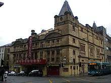
| |||
| 12 Rose Street, Glasgow Film Theatre | 55°51′57″N 4°15′40″W / 55.86571°N 4.261249°W | Category B | 33118 |
| |||
| 46-64 (Even Nos) St Enoch Square And 27-35 (Odd Nos) Howard Street | 55°51′26″N 4°15′22″W / 55.857169°N 4.256023°W | Category B | 33126 |
| |||
| 20-40 (Even Nos) Gordon Street And 1, 3 West Nile Street | 55°51′39″N 4°15′22″W / 55.8607°N 4.256052°W | Category A | 33031 |
| |||
| 45-47 (Odd Nos) Hill Street, And 21 Dalhousie Street, St Aloysius College | 55°52′01″N 4°15′50″W / 55.866838°N 4.263952°W | Category B | 33037 |
| |||
| 133, 135 Hill Street | 55°52′02″N 4°16′05″W / 55.86731°N 4.268071°W | Category B | 33041 |
| |||
| 140-150 (Even Nos) Hill Street, Former Beatson Hospital Annexe | 55°52′04″N 4°16′05″W / 55.867695°N 4.268158°W | Category B | 33047 |
| |||
| 19-23 (Odd Nos) Hope Street | 55°51′33″N 4°15′35″W / 55.859078°N 4.259761°W | Category B | 33049 |
| |||
| 154-158 (Even Nos) Hope Street | 55°51′47″N 4°15′27″W / 55.862928°N 4.257572°W | Category C(S) | 33057 |
| |||
| 27-59 (Odd Nos) James Watt Street And 42-52 (Even Nos) Brown Street | 55°51′27″N 4°15′52″W / 55.85756°N 4.264547°W | Category B | 33067 |
| |||
| 44-54 (Even Nos) James Watt Street (Known As 60 James Watt Street) | 55°51′30″N 4°15′50″W / 55.858266°N 4.263837°W | Category A | 33069 |
| |||
| 12-20 (Even Nos) Kelvingrove Street And 26-28 Westminster Terrace | 55°51′55″N 4°17′02″W / 55.865139°N 4.283879°W | Category B | 33073 |
| |||
| 152-154 (Even Nos) Bath Street | 55°51′52″N 4°15′39″W / 55.864569°N 4.260735°W | Category C(S) | 32966 |
| |||
| 256A Bath Street, Renfield St Stephen's Church, Former St Matthew's Blythswood (Church Of Scotland) | 55°51′55″N 4°16′01″W / 55.865309°N 4.2669°W | Category B | 32970 |
| |||
| 48-52 (Even Nos) Bothwell Street | 55°51′41″N 4°15′39″W / 55.861456°N 4.260906°W | Category B | 32986 |
| |||
| 45 Buchanan Street And 34-50 (Even Nos) Mitchell Street, Former Wylie And Lochead's | 55°51′33″N 4°15′19″W / 55.859094°N 4.255416°W | Category A | 32992 |
| |||
| 16-20 (Even Nos) Cambridge Street | 55°51′55″N 4°15′36″W / 55.865403°N 4.259873°W | Category B | 33007 |
| |||
| 3 Gilmorehill, University Of Glasgow, John Macintyre Building, University Avenue, Former Students Union | 55°52′20″N 4°17′20″W / 55.872211°N 4.288786°W | Category B | 32921 |
| |||
| 646-654 (Even Nos) Argyle Street, The Buttery | 55°51′39″N 4°16′18″W / 55.860933°N 4.271759°W | Category B | 32952 |
| |||
| 30 Queen Margaret Drive, Bbc | 55°52′43″N 4°17′13″W / 55.878672°N 4.286928°W | Category B | 32902 |
| |||
| 64 Southpark Avenue, Southpark House | 55°52′26″N 4°17′13″W / 55.873869°N 4.287078°W | Category B | 32907 | 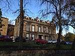
| |||
| 10 Dumbarton Road, Maggie's Centre, Former Western Infirmary Gate Lodge | 55°52′12″N 4°17′42″W / 55.870091°N 4.295008°W | Category C(S) | 32866 |
| |||
| 93-95 (Odd Nos) Hyndland Street, Cottier Theatre Complex, Former Dowanhill Church And Halls | 55°52′27″N 4°18′07″W / 55.87424°N 4.301903°W | Category A | 32879 |
| |||
| Wilson Street, Police Box | 55°51′31″N 4°14′55″W / 55.85874°N 4.248732°W | Category B | 32803 | 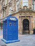
| |||
| 34-36 North Frederick Street, "Gladstone House" | 55°51′42″N 4°14′54″W / 55.861757°N 4.248395°W | Category B | 32811 |
| |||
| 134-148 (Even Nos) Queen Street With 13-14 George Square, Olympic House | 55°51′38″N 4°15′05″W / 55.860662°N 4.251304°W | Category B | 32821 |
| |||
| 1 St Andrews Square, St Andrews Parish Church (Church Of Scotland) | 55°51′17″N 4°14′34″W / 55.854821°N 4.242849°W | Category A | 32830 | 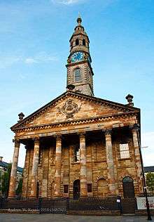
| |||
| 118-126 (Even Nos) Howard Street, Known As 126 Howard Street | 55°51′21″N 4°15′10″W / 55.855824°N 4.252909°W | Category B | 32728 |
| |||
| 177 Ingram Street With 99 Glassford Street | 55°51′35″N 4°14′56″W / 55.859616°N 4.249022°W | Category A | 32734 |
| |||
| 184-188 (Even Nos) Ingram Street And Return Elevation To South Frederick Street | 55°51′36″N 4°14′57″W / 55.860037°N 4.249078°W | Category B | 32747 |
| |||
| 13-21 (Odds) James Morrison Street And 2 St Andrew's Square | 55°51′19″N 4°14′34″W / 55.855283°N 4.242668°W | Category B | 32749 |
| |||
| 48-54 (Even Nos) Miller Street, (Formerly Stirling's Library) | 55°51′32″N 4°15′03″W / 55.858854°N 4.250863°W | Category A | 32761 |
| |||
| 62-70 (Even Nos) Miller Street Known As 70 Miller Street | 55°51′33″N 4°15′02″W / 55.859193°N 4.250547°W | Category B | 32762 |
| |||
| 23-25 (Odd Nos) Montrose Street And 8 Cochrane Street | 55°51′37″N 4°14′46″W / 55.860397°N 4.246111°W | Category B | 32764 |
| |||
| Smith's Court, South Side (Access From Pend At No 62 Brunswick Street) | 55°51′28″N 4°14′48″W / 55.857913°N 4.246798°W | Category B | 32766 |
| |||
| 157-159 (Odd Nos) Trongate Terleys | 55°51′26″N 4°14′54″W / 55.857147°N 4.2484°W | Category B | 32777 |
| |||
| 2-16 (Even Nos) Trongate/High Street, Quadrant With Bank Of Scotland | 55°51′25″N 4°14′38″W / 55.857015°N 4.243822°W | Category B | 32780 |
| |||
| 106-110 (Even Nos) Trongate And 3-9 (Odd Nos) Candleriggs | 55°51′26″N 4°14′47″W / 55.857335°N 4.246429°W | Category B | 32785 |
| |||
| 59-61 (Odd Nos) Virginia Street | 55°51′33″N 4°15′01″W / 55.859071°N 4.250301°W | Category C(S) | 32797 |
| |||
| 3 Castle Street, Provand's Lordship With Railings | 55°51′45″N 4°14′13″W / 55.86237°N 4.236987°W | Category A | 32648 | 
| |||
| Cathedral Square, Memorial Stone | 55°51′46″N 4°14′10″W / 55.862747°N 4.236034°W | Category C(S) | 32659 |
| |||
| Cathedral Square, Statue Of William Iii | 55°51′43″N 4°14′11″W / 55.861806°N 4.236332°W | Category A | 32660 | _statue_-_geograph.org.uk_-_940023.jpg)
| |||
| 52 Charlotte Street | 55°51′16″N 4°14′27″W / 55.854419°N 4.240749°W | Category A | 32663 |
| |||
| Clyde Street, Albert Bridge | 55°51′09″N 4°14′50″W / 55.852636°N 4.247356°W | Category A | 32667 | 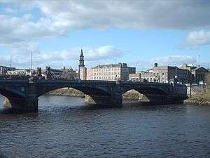
| |||
| 30 George Square And 7 West George Street, The Merchants' House | 55°51′41″N 4°15′06″W / 55.861516°N 4.251753°W | Category A | 32689 |
| |||
| George Square, Field Marshal Lord Clyde Statue | 55°51′39″N 4°15′01″W / 55.860889°N 4.250182°W | Category B | 32694 | 
| |||
| George Square, Robert Peel Statue | 55°51′41″N 4°15′04″W / 55.86152°N 4.251034°W | Category B | 32704 | 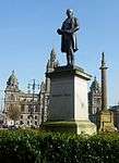
| |||
| George Square Thomas Graham Statue | 55°51′39″N 4°14′58″W / 55.860805°N 4.249378°W | Category B | 32705 | 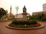
| |||
| 145-195 (Odd Nos) Albion Street | 55°51′36″N 4°14′38″W / 55.860078°N 4.243903°W | Category A | 32607 |
| |||
| 20 Buchanan Street | 55°51′31″N 4°15′16″W / 55.858717°N 4.254419°W | Category B | 32632 |
| |||
| 34-58 (Even Nos) Buchanan Street With 7-17 (Odd Nos) Springfield Court, Formerly Prince Of Wales Buildings Now Known As Princes Square | 55°51′33″N 4°15′16″W / 55.85914°N 4.25438°W | Category B | 32634 |
| |||
| 156-164 (Even Nos) Buchanan Street With 48-50 (Even Nos) West George Street, Tower Building | 55°51′44″N 4°15′12″W / 55.8622°N 4.253198°W | Category B | 32642 |
| |||
| 20-26 (Even Nos) Roxburgh Street And 33-35 (Odd Nos) Saltoun Street | 55°52′37″N 4°17′39″W / 55.876884°N 4.29413°W | Category B | 32583 | _ROXBURGH_STREET_AND_33-35_(ODD_NOS)_SALTOUN_STREET.jpg)
| |||
| 7 Victoria Circus, (Greenbank), With Outbuildings And Gatepiers | 55°52′43″N 4°18′02″W / 55.87848°N 4.300603°W | Category B | 32591 |
| |||
| 4 Victoria Circus, (Northcote) And Gatepiers | 55°52′45″N 4°18′02″W / 55.879264°N 4.300489°W | Category C(S) | 32592 |
| |||
| 8-12 (Inclusive Nos) Kirklee Quadrant | 55°52′54″N 4°17′39″W / 55.881689°N 4.294285°W | Category B | 32548 |
| |||
| 8 Prince Albert Road And 7 Sydenham Road With Boundary Wall And Gatepiers | 55°52′40″N 4°18′09″W / 55.877663°N 4.302457°W | Category B | 32574 |
| |||
| 24 Highburgh Road, And 3 And 7 Caledon Street, Western Telephone Exchange | 55°52′29″N 4°17′49″W / 55.874584°N 4.296983°W | Category B | 32521 |
| |||
| 1 Dundonald Road (Fern Tower) And Gatepiers | 55°52′41″N 4°17′51″W / 55.878114°N 4.297576°W | Category B | 32504 |
| |||
| 730 Great Western Road; Botanic Gardens, Curators House | 55°52′46″N 4°17′20″W / 55.879363°N 4.288904°W | Category B | 32509 |
| |||
| 174 Queen's Drive, Seventh Day Adventist Church | 55°50′07″N 4°16′13″W / 55.835212°N 4.270194°W | Category B | 32458 |
| |||
| 519-537 (Odd Nos) Victoria Road | 55°50′03″N 4°15′55″W / 55.834063°N 4.265288°W | Category C(S) | 32463 |
| |||
| Victoria Road, Queen's Park Station | 55°50′07″N 4°16′02″W / 55.835386°N 4.267106°W | Category B | 32466 | _Railway_Station_01.JPG)
| |||
| 35-53 (Odd Nos) Westmoreland Street, 165 Allison Street | 55°50′11″N 4°15′48″W / 55.836464°N 4.263224°W | Category C(S) | 32468 |
| |||
| Sandbank Street, Maryhill High Church, (Church Of Scotland) And Halls To 7 Aray Street | 55°53′33″N 4°17′37″W / 55.892398°N 4.293558°W | Category C(S) | 32357 |
| |||
| 30-36 (Even Nos) Sandy Road, 120-124 (Even Nos) Beith Street, Former Partick Fire Station | 55°52′09″N 4°18′55″W / 55.869243°N 4.315306°W | Category B | 32297 | 
| |||
| Forth And Clyde Canal Aqueduct (Adjoining Skaethorn Road Bridge) | 55°53′33″N 4°18′06″W / 55.892397°N 4.301795°W | Category A | 32316 |
| |||
| 1051 Great Western Road And Adjoining Retaining Walls And Balustrade (Carriages Restaurant) | 55°53′03″N 4°18′34″W / 55.884155°N 4.309494°W | Category B | 32317 |
| |||
| 1055 Great Western Road Gartnavel Royal Hospital, Garden, Boundary And Retaining Walls | 55°53′01″N 4°19′09″W / 55.883568°N 4.319213°W | Category A | 32318 |
| |||
| 1099 Great Western Road, 6 Whittingehame Gardens | 55°53′11″N 4°18′59″W / 55.886495°N 4.316477°W | Category C(S) | 32327 |
|
Key
The scheme for classifying buildings in Scotland is:
- Category A: "buildings of national or international importance, either architectural or historic, or fine little-altered examples of some particular period, style or building type."[1]
- Category B: "buildings of regional or more than local importance, or major examples of some particular period, style or building type which may have been altered."[1]
- Category C(S): "buildings of local importance, lesser examples of any period, style, or building type, as originally constructed or moderately altered; and simple traditional buildings which group well with others in categories A and B."[1]
There are approximately 47,400 listed buildings in Scotland. Of these, around 8 per cent (some 3,800) are Category A, and 51 per cent (24,000) are Category B, with the rest listed at Category C(s).[2]
See also
Notes
- ↑ Sometimes known as OSGB36, the grid reference (where provided) is based on the British national grid reference system used by the Ordnance Survey.
• "Guide to National Grid". Ordnance Survey. Retrieved 2007-12-12.
• "Get-a-map". Ordnance Survey. Retrieved 2007-12-17. - ↑ The "HB Number" is a unique number assigned to each listed building by Historic Scotland.
References
- All entries, addresses and coordinates are based on data from Historic Scotland. This data falls under the Open Government Licence
- 1 2 3 "What is Listing?". Historic Scotland. Retrieved 2010-07-06.
- ↑ Guide to the Protection of Scotland’s Listed Buildings (PDF). Historic Scotland. 2009. p. 17. ISBN 978-1-84917-013-0. Retrieved 2010-07-06.
This article is issued from Wikipedia - version of the 11/9/2016. The text is available under the Creative Commons Attribution/Share Alike but additional terms may apply for the media files.