List of listed buildings in Kilchoman, Argyll and Bute
This is a list of listed buildings in the parish of Kilchoman in Argyll and Bute, Scotland.
List
| Name | Location | Date Listed | Grid Ref. [note 1] | Geo-coordinates | Notes | HB Number [note 2] | Image |
|---|---|---|---|---|---|---|---|
| Portnahaven School | 55°40′49″N 6°30′03″W / 55.680326°N 6.500933°W | Category B | 12437 | 
| |||
| Kilchiaran Farmhouse | 55°45′21″N 6°27′03″W / 55.75589°N 6.450774°W | Category B | 11898 |
| |||
| Bruichladdich Gorton Schoolhouse And Former School | 55°46′48″N 6°21′09″W / 55.779933°N 6.352507°W | Category B | 11911 |
| |||
| Houses, Main Street Sraid Ard (E. Side, Middle) 1. Mclellan 2. Clark 3. Kidd 4. Gillies 5. Mckinven 6 Rothschild | 55°44′21″N 6°22′41″W / 55.739255°N 6.37815°W | Category B | 11928 |
| |||
| Police Station And House (Lochview), Rathad Na Roinne (W. Side) | 55°44′12″N 6°22′54″W / 55.736734°N 6.381757°W | Category C(S) | 11937 |
| |||
| Houses Bruthach Dubh W. Side 1. Boyle 2. Leitch 3. Maclean 4. Gillespie 5. Mactaggart And Henderson 6. Donald 7. Macindeor 8. Mcdougall 9. Mackintosh | 55°44′24″N 6°22′44″W / 55.740122°N 6.378806°W | Category B | 11948 |
| |||
| "Rhu" By Port Na Ceasach, 1. Dick, 2. Mclelland | 55°44′17″N 6°22′43″W / 55.73816°N 6.378601°W | Category B | 12436 |
| |||
| Hugh Mackay's Grave, (Tung Mhic Aoidh Na Ranna) | 55°40′32″N 6°30′45″W / 55.67549°N 6.51257°W | Category B | 11895 |
| |||
| St. Ciaran's Chapel Kilchiaran | 55°45′12″N 6°27′25″W / 55.753406°N 6.456998°W | Category B | 11897 |
| |||
| Kilchiaran Steading | 55°45′19″N 6°27′12″W / 55.755302°N 6.453339°W | Category B | 11899 |
| |||
| Nave Island Chapel Nave Island | 55°53′58″N 6°20′01″W / 55.899558°N 6.333723°W | Category B | 11909 |
| |||
| 26, 27, 28 & 29 Shore Street (Sraid A'Chladdaich) (Middle) | 55°44′21″N 6°22′39″W / 55.739193°N 6.377617°W | Category B | 11924 |
| |||
| House, (Woodrow & Ross) Bruthach An Diolladair | 55°44′20″N 6°22′41″W / 55.73878°N 6.378113°W | Category C(S) | 11927 |
| |||
| Houses, Main Street (Sraid Ard) (W. Side, N. End) 1) Macarther, 2) Mcindeor 3) Miss Mcindeor 4) Fergusson 5) Mciver 6) Grier | 55°44′24″N 6°22′43″W / 55.73988°N 6.378539°W | Category B | 11929 |
| |||
| Houses, Main St. Sraid Ard (W. Side, S. End) 1) Mclelland, 2) Mcsween 3) Fergusson 4) Beattie | 55°44′19″N 6°22′45″W / 55.738508°N 6.379183°W | Category B | 11931 |
| |||
| 'Laggan View' Rathad Na Roinne (W. Side) | 55°44′17″N 6°22′47″W / 55.738104°N 6.379663°W | Category C(S) | 11933 |
| |||
| Portnahaven Church Of Scotland | 55°40′52″N 6°30′25″W / 55.68112°N 6.506963°W | Category B | 11940 |
| |||
| Bonded Warehouses Lochindaal Distillery | 55°44′28″N 6°22′44″W / 55.741118°N 6.37887°W | Category C(S) | 11947 |
| |||
| Port Charlotte Hotel | 55°44′25″N 6°22′42″W / 55.740269°N 6.378471°W | Category C(S) | 11949 |
| |||
| Houses, Cnoc Iain Phail And Shore Street (Sraid A'Chladdaich) (N. End) 1) Storehouse, 2) Maciore, 3) Toirre, 4) Mactaggart And Maclean, 5) Johnson | 55°44′23″N 6°22′39″W / 55.739663°N 6.377574°W | Category B | 13793 |
| |||
| Brookfield (Old Manse) | 55°40′52″N 6°30′11″W / 55.681067°N 6.503024°W | Category C(S) | 11942 |
| |||
| Atlantic View (Fergusson's) | 55°40′48″N 6°30′21″W / 55.680009°N 6.50588°W | Category C(S) | 11943 |
| |||
| St. Oran's Chapel | 55°40′32″N 6°30′45″W / 55.67549°N 6.51257°W | Category B | 11945 |
| |||
| Kilchoman Manse, Bruichladdich - Port Charlotte Road | 55°44′53″N 6°22′28″W / 55.748034°N 6.374383°W | Category C(S) | 11946 |
| |||
| Houses 1. Mckinnon 2. Thomson | 55°40′35″N 6°30′18″W / 55.676492°N 6.505124°W | Category B | 13792 |
| |||
| Port Charlotte Road, Kilchoman New Parish Church (St Ciaran's), Bruichladdich | 55°45′06″N 6°22′22″W / 55.751728°N 6.372676°W | Category B | 13818 |
| |||
| Foreland House | 55°47′41″N 6°21′27″W / 55.794713°N 6.357511°W | Category B | 11901 |
| |||
| Lochindaal Hotel And Houses Main Street (Sraid Ard) (W. Side Middle) 1) Macdonald, 2) Carmichael, 3) Hotel, 4) Bar, 5) Miss Gillespie 6) Gillespie | 55°44′20″N 6°22′43″W / 55.738913°N 6.37867°W | Category B | 11930 |
| |||
| Kilchoman Old Parish Church Kilchoman | 55°46′55″N 6°26′30″W / 55.781986°N 6.441799°W | Category B | 11902 | 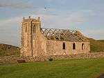
| |||
| Kilnave Chapel (Cill Naoimh), Kilnave Burial Ground | 55°51′37″N 6°20′25″W / 55.860374°N 6.340211°W | Category B | 11905 | 
| |||
| Houses, Rathad Na Roinne (W. Side) 1. W. Campbell 2. S. Campbell | 55°44′16″N 6°22′48″W / 55.737905°N 6.379928°W | Category C(S) | 11934 |
| |||
| Old Blacksmith's House (Burke) Rathad Na Roinne (W. Side) | 55°44′15″N 6°22′49″W / 55.737547°N 6.380382°W | Category C(S) | 11935 |
| |||
| Bruichladdich Distillery | 55°45′58″N 6°21′43″W / 55.766083°N 6.361825°W | Category C(S) | 11900 | 
| |||
| Kilchoman Cross, Kilchoman Burial Ground | 55°46′54″N 6°26′30″W / 55.781803°N 6.441634°W | Category B | 11903 | 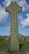
| |||
| Kilnave Cross, Kilnave Burial Ground | 55°51′37″N 6°20′25″W / 55.860178°N 6.340157°W | Category B | 11906 | 
| |||
| Craigens Farmhouse And Steading | 55°49′19″N 6°18′59″W / 55.821883°N 6.316345°W | Category B | 11910 |
| |||
| 22, 23 & 24 Shore Street (Sraid A'Chladdaich) (S. End) | 55°44′20″N 6°22′40″W / 55.738793°N 6.377732°W | Category B | 11925 |
| |||
| House (Campbell) Bruthach An Diolladair | 55°44′20″N 6°22′41″W / 55.738775°N 6.377985°W | Category C(S) | 11926 |
| |||
| House, (Mctaggart) Rathad Na Roinne (W. Side) | 55°44′15″N 6°22′50″W / 55.7375°N 6.380441°W | Category C(S) | 11936 |
| |||
| "Achnamara" Rathad Na Roinne (E. Side) | 55°44′16″N 6°22′47″W / 55.737703°N 6.37981°W | Category C(S) | 11938 |
| |||
| Port Charlotte Village Sraid Na Sgoile Port Charlotte Village Hall | 55°44′20″N 6°22′49″W / 55.738993°N 6.380194°W | Category B | 11941 |
| |||
| Cottage (Belonging To Ferguson, Farmer) Near Balmenach | 55°41′28″N 6°30′12″W / 55.691037°N 6.50344°W | Category B | 11896 |
| |||
| Ardnave Steading | 55°52′26″N 6°20′45″W / 55.873829°N 6.345826°W | Category B | 11908 |
| |||
| Rhinns Of Islay Lighthouse | 55°40′23″N 6°30′48″W / 55.673082°N 6.513232°W | Category A | 11944 |
| |||
| Kilchoman House (Old Manse) Kilchoman | 55°46′52″N 6°26′27″W / 55.781101°N 6.4409°W | Category B | 11904 |
| |||
| Ardnave House | 55°52′25″N 6°20′42″W / 55.873583°N 6.344902°W | Category B | 11907 |
| |||
| Cottage, Rathad Na Roinne (W. Side) | 55°44′17″N 6°22′46″W / 55.738179°N 6.379576°W | Category C(S) | 11932 |
| |||
| Cottage, (Clark) Rathad Na Roinne (E. Side) | 55°44′16″N 6°22′47″W / 55.737799°N 6.379645°W | Category C(S) | 11939 |
|
Key
The scheme for classifying buildings in Scotland is:
- Category A: "buildings of national or international importance, either architectural or historic, or fine little-altered examples of some particular period, style or building type."[1]
- Category B: "buildings of regional or more than local importance, or major examples of some particular period, style or building type which may have been altered."[1]
- Category C(S): "buildings of local importance, lesser examples of any period, style, or building type, as originally constructed or moderately altered; and simple traditional buildings which group well with others in categories A and B."[1]
There are approximately 47,400 listed buildings in Scotland. Of these, around 8 per cent (some 3,800) are Category A, and 51 per cent (24,000) are Category B, with the rest listed at Category C(s).[2]
See also
Notes
- ↑ Sometimes known as OSGB36, the grid reference (where provided) is based on the British national grid reference system used by the Ordnance Survey.
• "Guide to National Grid". Ordnance Survey. Retrieved 2007-12-12.
• "Get-a-map". Ordnance Survey. Retrieved 2007-12-17. - ↑ The "HB Number" is a unique number assigned to each listed building by Historic Scotland.
References
- All entries, addresses and coordinates are based on data from Historic Scotland. This data falls under the Open Government Licence
- 1 2 3 "What is Listing?". Historic Scotland. Retrieved 2010-07-06.
- ↑ Guide to the Protection of Scotland’s Listed Buildings (PDF). Historic Scotland. 2009. p. 17. ISBN 978-1-84917-013-0. Retrieved 2010-07-06.
This article is issued from Wikipedia - version of the 10/15/2016. The text is available under the Creative Commons Attribution/Share Alike but additional terms may apply for the media files.