List of listed buildings in Killarow And Kilmeny, Argyll and Bute
This is a list of listed buildings in the parish of Killarow And Kilmeny in Argyll and Bute, Scotland.
List
| Name | Location | Date Listed | Grid Ref. [note 1] | Geo-coordinates | Notes | HB Number [note 2] | Image |
|---|---|---|---|---|---|---|---|
| Bridgend Hotel And Steading | 55°46′51″N 6°14′57″W / 55.78078°N 6.249054°W | Category C(S) | 12189 | 
| |||
| House (Campbell) Shop, And Post Office By River Sorn | 55°46′53″N 6°14′59″W / 55.781427°N 6.249826°W | Category C(S) | 12190 |
| |||
| Islay Home Farm | 55°47′07″N 6°15′05″W / 55.785248°N 6.251424°W | Category B | 12144 |
| |||
| Bluehouse, Islay House Estate | 55°47′09″N 6°15′37″W / 55.785888°N 6.260225°W | Category B | 12149 |
| |||
| East Lodge And Gate-Way, Islay House Estate | 55°47′47″N 6°12′59″W / 55.796355°N 6.216522°W | Category B | 12153 |
| |||
| Store-House (D. Macbranes) Port Askaig Pier | 55°50′55″N 6°06′18″W / 55.848745°N 6.104987°W | Category C(S) | 12166 |
| |||
| John Francis Campbell Monument Rear St. Columba's Episcopal Church | 55°46′32″N 6°14′56″W / 55.775631°N 6.248907°W | Category C(S) | 12188 |
| |||
| Dry Bridge Over Bridgend-Ballygrant Road, Islay House Estate | 55°46′58″N 6°14′57″W / 55.782817°N 6.249164°W | Category C(S) | 12145 |
| |||
| Port Askaig Hotel | 55°50′52″N 6°06′20″W / 55.847704°N 6.105453°W | Category C(S) | 12162 |
| |||
| Houses (F.T. Spears) Shop | 55°50′53″N 6°06′21″W / 55.847937°N 6.105749°W | Category C(S) | 12163 |
| |||
| Port Askaig, Jetty | 55°50′53″N 6°06′17″W / 55.848084°N 6.104838°W | Category C(S) | 12164 |
| |||
| Piermasters Shipping Office (D. Macbranes) House And Post Office Port Askaig | 55°50′54″N 6°06′18″W / 55.848454°N 6.105069°W | Category C(S) | 12165 |
| |||
| Bridge, River Laggan Bowmore-Port Ellen Low Road | 55°43′51″N 6°17′11″W / 55.730847°N 6.286447°W | Category C(S) | 12430 |
| |||
| Rhuvaal Lighthouse, Rudh A' Mhail | 55°56′11″N 6°07′25″W / 55.936404°N 6.123529°W | Category B | 12117 |
| |||
| Gardeners House And Gate Piers. Islay House Estate | 55°46′54″N 6°15′07″W / 55.781697°N 6.251899°W | Category C(S) | 12146 |
| |||
| East Tower Near Gate-Lodge Islay House Estate | 55°46′55″N 6°15′06″W / 55.781956°N 6.251688°W | Category B | 12147 |
| |||
| Eallabus House | 55°47′20″N 6°15′06″W / 55.789007°N 6.251707°W | Category B | 12150 |
| |||
| Dunlossit House Estate, Memorial Cross (Shaft) | 55°50′50″N 6°06′32″W / 55.847206°N 6.108789°W | Category C(S) | 47367 |
| |||
| Bridge House Beside Bridge Over River Laggan | 55°43′51″N 6°17′10″W / 55.73085°N 6.286097°W | Category C(S) | 12431 |
| |||
| Kilarrow Parish Church, Main Street | 55°45′18″N 6°17′11″W / 55.755069°N 6.286429°W | Category A | 12184 | 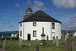
| |||
| Islay Woollen Mill And Bridge | 55°47′22″N 6°13′30″W / 55.789564°N 6.224902°W | Category A | 12143 |
| |||
| Emeraconart Cottage | 55°48′34″N 6°11′54″W / 55.809502°N 6.198461°W | Category C(S) | 12156 |
| |||
| Dunlossit House | 55°50′45″N 6°06′15″W / 55.845899°N 6.104287°W | Category C(S) | 12160 |
| |||
| Island House | 55°43′43″N 6°17′24″W / 55.728604°N 6.289883°W | Category B | 12187 |
| |||
| West Tower, Islay House Estate | 55°47′02″N 6°16′24″W / 55.784013°N 6.273268°W | Category B | 12148 |
| |||
| Newton House | 55°47′04″N 6°14′12″W / 55.784431°N 6.236571°W | Category C(S) | 12151 |
| |||
| Daill House | 55°47′04″N 6°12′26″W / 55.784562°N 6.207154°W | Category B | 12152 |
| |||
| Kilmeny (Former Manse) | 55°48′48″N 6°10′16″W / 55.81331°N 6.171192°W | Category B | 12155 |
| |||
| Finlaggan Castle, Eilean Mor, Loch Finlaggan | 55°50′07″N 6°10′22″W / 55.835271°N 6.172827°W | Category C(S) | 12158 | 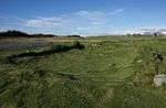
| |||
| Shore Street, House At Scws Filling Station | 55°45′26″N 6°17′11″W / 55.757237°N 6.286412°W | Category B | 12429 |
| |||
| Bridge, River Sorn | 55°46′54″N 6°14′58″W / 55.781584°N 6.24946°W | Category B | 12191 |
| |||
| Veterinary Surgery (Beside Bridge) River Sorn | 55°46′54″N 6°14′59″W / 55.781713°N 6.249618°W | Category B | 12141 |
| |||
| 61 Jamieson Street, Cottage | 55°45′24″N 6°17′05″W / 55.756768°N 6.284669°W | Category C(S) | 12428 |
| |||
| Islay House, Gateway At Entrance To Strand Legal Plantation | 55°46′54″N 6°15′05″W / 55.781543°N 6.251419°W | Category C(S) | 12432 |
| |||
| Town Hall, Main Street | 55°45′21″N 6°17′13″W / 55.755843°N 6.286944°W | Category B | 12185 |
| |||
| Cottage, (D. Gillies) 59-60 Jamieson Street | 55°45′24″N 6°17′05″W / 55.756747°N 6.284747°W | Category C(S) | 12186 |
| |||
| Bunnahabhan Distillery, Bonahaven Bay | 55°52′58″N 6°07′34″W / 55.882681°N 6.126079°W | Category C(S) | 12116 |
| |||
| Kilfinlaggan Chapel, Eilean Mor, Loch Finlaggan | 55°50′08″N 6°10′19″W / 55.835505°N 6.172037°W | Category C(S) | 12159 | 
| |||
| Bowmore Village, High Street, Former Free Church Including Perimeter Wall And Gatepiers | 55°45′22″N 6°17′03″W / 55.756124°N 6.284056°W | Category C(S) | 12947 |
| |||
| Islay House | 55°47′05″N 6°15′15″W / 55.784841°N 6.254093°W | Category A | 12142 |
| |||
| Kilmeny Parish Church | 55°48′51″N 6°10′06″W / 55.814059°N 6.168205°W | Category B | 12154 |
| |||
| Knocklearoch Farm-House And Steading | 55°48′26″N 6°09′09″W / 55.80732°N 6.152632°W | Category C(S) | 12157 |
| |||
| Heatherhouse, Caol Ila | 55°51′04″N 6°07′04″W / 55.85116°N 6.117745°W | Category B | 12161 |
|
Key
The scheme for classifying buildings in Scotland is:
- Category A: "buildings of national or international importance, either architectural or historic, or fine little-altered examples of some particular period, style or building type."[1]
- Category B: "buildings of regional or more than local importance, or major examples of some particular period, style or building type which may have been altered."[1]
- Category C(S): "buildings of local importance, lesser examples of any period, style, or building type, as originally constructed or moderately altered; and simple traditional buildings which group well with others in categories A and B."[1]
There are approximately 47,400 listed buildings in Scotland. Of these, around 8 per cent (some 3,800) are Category A, and 51 per cent (24,000) are Category B, with the rest listed at Category C(s).[2]
See also
Notes
- ↑ Sometimes known as OSGB36, the grid reference (where provided) is based on the British national grid reference system used by the Ordnance Survey.
• "Guide to National Grid". Ordnance Survey. Retrieved 2007-12-12.
• "Get-a-map". Ordnance Survey. Retrieved 2007-12-17. - ↑ The "HB Number" is a unique number assigned to each listed building by Historic Scotland.
References
- All entries, addresses and coordinates are based on data from Historic Scotland. This data falls under the Open Government Licence
- 1 2 3 "What is Listing?". Historic Scotland. Retrieved 2010-07-06.
- ↑ Guide to the Protection of Scotland’s Listed Buildings (PDF). Historic Scotland. 2009. p. 17. ISBN 978-1-84917-013-0. Retrieved 2010-07-06.
This article is issued from Wikipedia - version of the 10/15/2016. The text is available under the Creative Commons Attribution/Share Alike but additional terms may apply for the media files.