List of listed buildings in Tobermory, Mull
This is a list of listed buildings in the parish of Tobermory in Argyll and Bute, Scotland.
List
| Name |
Location |
Date Listed |
Grid Ref. [note 1] |
Geo-coordinates |
Notes |
HB Number [note 2] |
Image |
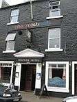
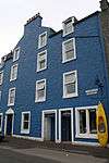
| Mishnish Hotel Main Street |
|
|
|
56°37′23″N 6°03′56″W / 56.623133°N 6.065475°W / 56.623133; -6.065475 (Mishnish Hotel Main Street) |
Category C(S) |
42075 |
 Upload another image
|
| Black's Land, 26, 25, 24, Main Street |
|
|
|
56°37′23″N 6°04′04″W / 56.62312°N 6.06779°W / 56.62312; -6.06779 (Black's Land, 26, 25, 24, Main Street) |
Category C(S) |
42067 |
 Upload another image
|
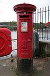
| Tobermory Pier, Edward VIII Post Box With Sign |
|
|
|
56°37′23″N 6°03′53″W / 56.623078°N 6.064669°W / 56.623078; -6.064669 (Tobermory Pier, Edward VIII Post Box With Sign) |
Category B |
44586 |
 Upload another image
|
| Erray Farm And Farmhouse |
|
|
|
56°37′51″N 6°04′18″W / 56.630886°N 6.071743°W / 56.630886; -6.071743 (Erray Farm And Farmhouse) |
Category B |
42073 |

|
| Old Pier Main Street |
|
|
|
56°37′21″N 6°04′03″W / 56.622425°N 6.067601°W / 56.622425; -6.067601 (Old Pier Main Street) |
Category B |
42064 |
 Upload another image
|
| Court House |
|
|
|
56°37′15″N 6°04′21″W / 56.620955°N 6.072401°W / 56.620955; -6.072401 (Court House) |
Category B |
42072 |
|
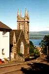
| Tobermory Parish Church, Victoria Street |
|
|
|
56°37′24″N 6°04′13″W / 56.623435°N 6.070271°W / 56.623435; -6.070271 (Tobermory Parish Church, Victoria Street) |
Category C(S) |
42059 |
 Upload another image
|
| 'Mansefield', Breadalbane Street |
|
|
|
56°37′26″N 6°04′15″W / 56.624016°N 6.07092°W / 56.624016; -6.07092 ('Mansefield', Breadalbane Street) |
Category B |
42060 |
|
| 'Springbank' |
|
|
|
56°37′24″N 6°04′10″W / 56.62329°N 6.069472°W / 56.62329; -6.069472 ('Springbank') |
Category B |
42061 |
|
| The Gallery (Formerly Free Church), Main Street, Tobermory |
|
|
|
56°37′22″N 6°04′08″W / 56.62272°N 6.069019°W / 56.62272; -6.069019 (The Gallery (Formerly Free Church), Main Street, Tobermory) |
Category B |
42070 |
 Upload another image
|
| 35, 34-33 Main Street |
|
|
|
56°37′22″N 6°04′07″W / 56.622782°N 6.068504°W / 56.622782; -6.068504 (35, 34-33 Main Street) |
Category C(S) |
42063 |
|
| Portmore Buildings, Main Street |
|
|
|
56°37′23″N 6°03′57″W / 56.623089°N 6.065731°W / 56.623089; -6.065731 (Portmore Buildings, Main Street) |
Category C(S) |
42074 |
|
| Royal Buildings, Main Street |
|
|
|
56°37′23″N 6°03′55″W / 56.623176°N 6.065251°W / 56.623176; -6.065251 (Royal Buildings, Main Street) |
Category C(S) |
42076 |
 Upload another image
|
| Post Office, 36 Main Street |
|
|
|
56°37′22″N 6°04′08″W / 56.622808°N 6.068816°W / 56.622808; -6.068816 (Post Office, 36 Main Street) |
Category C(S) |
42062 |
 Upload another image
|
| Rockcliffe, Main Street |
|
|
|
56°37′24″N 6°03′54″W / 56.623284°N 6.064985°W / 56.623284; -6.064985 (Rockcliffe, Main Street) |
Category C(S) |
42077 |
|
| Brown's Land, 23, 22, 21, Main Street |
|
|
|
56°37′23″N 6°04′03″W / 56.623173°N 6.067551°W / 56.623173; -6.067551 (Brown's Land, 23, 22, 21, Main Street) |
Category C(S) |
42068 |
 Upload another image
|
| Rockburn, Main Street (House In Close Behind 28 Main Street) |
|
|
|
56°37′24″N 6°04′07″W / 56.623246°N 6.068603°W / 56.623246; -6.068603 (Rockburn, Main Street (House In Close Behind 28 Main Street)) |
Category C(S) |
42069 |
|
| 28 Main Street |
|
|
|
56°37′23″N 6°04′05″W / 56.623005°N 6.068006°W / 56.623005; -6.068006 (28 Main Street) |
Category C(S) |
42065 |
|
| 27 Main Street |
|
|
|
56°37′23″N 6°04′04″W / 56.623071°N 6.067915°W / 56.623071; -6.067915 (27 Main Street) |
Category C(S) |
42066 |
|
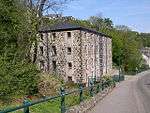
| Old Bonded Warehouse Of Tobermory, Distillery Ledaig |
|
|
|
56°37′15″N 6°04′15″W / 56.620868°N 6.07094°W / 56.620868; -6.07094 (Old Bonded Warehouse Of Tobermory, Distillery Ledaig) |
Category B |
42071 |
 Upload another image
|
Key
The scheme for classifying buildings in Scotland is:
- Category A: "buildings of national or international importance, either architectural or historic, or fine little-altered examples of some particular period, style or building type."[1]
- Category B: "buildings of regional or more than local importance, or major examples of some particular period, style or building type which may have been altered."[1]
- Category C(S): "buildings of local importance, lesser examples of any period, style, or building type, as originally constructed or moderately altered; and simple traditional buildings which group well with others in categories A and B."[1]
There are approximately 47,400 listed buildings in Scotland. Of these, around 8 per cent (some 3,800) are Category A, and 51 per cent (24,000) are Category B, with the rest listed at Category C(s).[2]
See also
Notes
References