List of protected heritage sites in Anthisnes
This table shows an overview of the protected heritage sites in the Walloon town Anthisnes. This list is part of Belgium's national heritage.
| Object |
Year/architect |
Town/section |
Address |
Coordinates |
Number? |
Image |
|---|---|---|---|---|---|---|
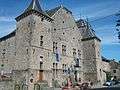
| Saint-Laurant abbey farm (nl) (fr) |
Anthisnes | avenue de l'Abbaye n°4 | 50°28′48″N 5°31′31″E / 50.479970°N 5.525236°E |
61079-CLT-0001-01 Info |
_JPG01.jpg) | |
| castle Avouerie (nl) (fr) |
Anthisnes | avenue de l'Abbaye 19 | 50°28′47″N 5°31′24″E / 50.479754°N 5.523254°E |
61079-CLT-0003-01 Info |
 | |
| Old Brasserie near Castle Avouerie (nl) (fr) |
Anthisnes | 50°28′47″N 5°31′25″E / 50.479806°N 5.523585°E |
61079-CLT-0004-01 Info |
|||
| Elm tree <sup style="text-align:right; line-height:1em;
margin-left:0.3em; color:blue; cursor:help; font-family:Verdana,sans-serif;"
title="Linde: "tilleul des Floxhes"">(nl) (fr) |
Anthisnes | 50°28′10″N 5°29′44″E / 50.469493°N 5.495473°E |
61079-CLT-0005-01 Info |
|||
| Site of church St. Pierre and graveyard (nl) (fr) |
Anthisnes | 50°29′14″N 5°30′04″E / 50.487333°N 5.501225°E |
61079-CLT-0006-01 Info |
|||
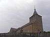
| Church of St. Pierre (nl) (fr) |
Anthisnes | 50°29′14″N 5°30′06″E / 50.487296°N 5.501531°E |
61079-CLT-0007-01 Info |
 | ||
| Castle Vien (nl) (fr) |
Anthisnes | rue de l'Église, n°s 20-22 | 50°28′31″N 5°29′46″E / 50.475413°N 5.495983°E |
61079-CLT-0008-01 Info |
||
| Castle Vien park grounds (nl) (fr) |
Anthisnes | rue de l'Église, n°s 20-22 | 50°28′33″N 5°29′25″E / 50.475878°N 5.490232°E |
61079-CLT-0009-01 Info |
||
| Organs of St. Martin's church (nl) (fr) |
Anthisnes | 50°29′47″N 5°28′16″E / 50.496300°N 5.471090°E |
61079-CLT-0010-01 Info |
|||
| Valley of Tavier (nl) (fr) |
Anthisnes | 50°29′22″N 5°27′39″E / 50.489440°N 5.460929°E |
61079-CLT-0011-01 Info |
|||
| "d'Omalius" farmhouse <sup style="text-align:right; line-height:1em;
margin-left:0.3em; color:blue; cursor:help; font-family:Verdana,sans-serif;"
title="Delen van de boerderij "d'Omalius"">(nl) (fr) |
Anthisnes | avenue de l'Abbaye 2 | 50°28′46″N 5°31′32″E / 50.479392°N 5.525420°E |
61079-CLT-0012-01 Info |
||
| Castle Villers-aux-Tours (nl) (fr) |
Anthisnes | Anthisnes | 50°30′04″N 5°31′05″E / 50.501077°N 5.518150°E |
61079-CLT-0013-01 Info |
||
| Saint-Maximin church frescoes (nl) (fr) |
Anthisnes | 50°28′47″N 5°31′31″E / 50.479755°N 5.525204°E |
61079-PEX-0001-01 Info |
|||
| 16th and 18th century frescoes in the church of St. Pierre (nl) (fr) |
Anthisnes | Hody | 50°29′14″N 5°30′06″E / 50.487296°N 5.501531°E |
61079-PEX-0002-01 Info |
See also
| Wikimedia Commons has media related to Cultural heritage monuments in Anthisnes. |
References
- Belgian heritage register: Direction générale opérationnelle - Aménagement du territoire, Logement, Patrimoine et Energie (DG4)
This article is issued from Wikipedia - version of the 9/24/2016. The text is available under the Creative Commons Attribution/Share Alike but additional terms may apply for the media files.