List of protected heritage sites in Clavier, Liège
This table shows an overview of the protected heritage sites in the Walloon town Clavier. This list is part of Belgium's national heritage.
| Object |
Year/architect |
Town/section |
Address |
Coordinates |
Number? |
Image |
|---|---|---|---|---|---|---|
| Border marker called "Li pire al gatte" <sup style="text-align:right; line-height:1em;
margin-left:0.3em; color:blue; cursor:help; font-family:Verdana,sans-serif;"
title="Grenspaal genaamd "Li pire al gatte"">(nl) (fr) |
Clavier | 50°25′40″N 5°24′35″E / 50.427718°N 5.409589°E |
61012-CLT-0001-01 Info |
|||
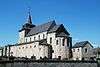
| Choir and nave of the church of St. Lambert (nl) (fr) |
Clavier | Bois | 50°23′51″N 5°20′15″E / 50.397538°N 5.337471°E |
61012-CLT-0005-01 Info |
.jpg) | |
| Tower of the church of St. Martin (nl) (fr) |
Clavier | les Avins-en-Condroz | 50°24′56″N 5°17′58″E / 50.415489°N 5.299421°E |
61012-CLT-0006-01 Info |
||
| Public square called "Bati de Pair" and surroundings with linden tree <sup style="text-align:right; line-height:1em;
margin-left:0.3em; color:blue; cursor:help; font-family:Verdana,sans-serif;"
title=""Pierre au sacrement", openbaar plein genaamd "Bati de Pair", de straat chemin de Messe en de lindeboom van Patte d'Oise">(nl) (fr) |
Clavier | 50°26′39″N 5°24′09″E / 50.444276°N 5.402622°E |
61012-CLT-0007-01 Info |
|||
| Organs of the church of St. Martin (nl) (fr) |
Clavier | 50°24′56″N 5°17′58″E / 50.415533°N 5.299336°E |
61012-CLT-0008-01 Info |
|||
| Church of St. Remacle (nl) (fr) |
Clavier | 50°23′47″N 5°23′44″E / 50.396524°N 5.395447°E |
61012-CLT-0010-01 Info |
 | ||
| Moins courtyard and surrounding walls (nl) (fr) |
Clavier | 50°23′50″N 5°23′44″E / 50.397321°N 5.395578°E |
61012-CLT-0011-01 Info |
|||
| chapel of St. Vierge (nl) (fr) |
Clavier | 50°24′50″N 5°14′39″E / 50.413752°N 5.244191°E |
61012-CLT-0012-01 Info |
|||
| 2 linden trees at entrance to the graveyard of "Bati de Pair" <sup style="text-align:right; line-height:1em;
margin-left:0.3em; color:blue; cursor:help; font-family:Verdana,sans-serif;"
title="Twee lindebomen links en rechts van de ingang van de begraafplaats aan de plaats "Bati de Pair" in het gehucht Pair">(nl) (fr) |
Clavier | 50°26′31″N 5°24′09″E / 50.442014°N 5.402405°E |
61012-CLT-0013-01 Info |
|||
| Castle Vervoz (nl) (fr) |
Clavier | 50°23′33″N 5°21′45″E / 50.392564°N 5.362547°E |
61012-CLT-0014-01 Info |
|||
| Ice cellar and water pump of the castle (nl) (fr) |
Clavier | Allée du puits, Ochain | 50°25′44″N 5°21′58″E / 50.428789°N 5.365999°E |
61012-CLT-0015-01 Info |
||
| Old house (nl) (fr) |
Clavier | rue Roi Albert n°1 | 50°25′37″N 5°21′24″E / 50.426828°N 5.356584°E |
61012-CLT-0016-01 Info |
||
| Organs of the church of St. Martin (nl) (fr) |
Clavier | Borsu | 50°23′18″N 5°19′18″E / 50.388440°N 5.321780°E |
61012-CLT-0018-01 Info |
||
| "Aux Gives" farmhouse <sup style="text-align:right; line-height:1em;
margin-left:0.3em; color:blue; cursor:help; font-family:Verdana,sans-serif;"
title="Boerderij "Aux Grives": het huis, de oude stallen, de schuur, bijgebouw omgebouwd tot conciërgerie, schuren, en de muren, een voorsprong van het pand en de andere eindigt in het oosten.">(nl) (fr) |
Clavier | Roua n°17 | 50°23′50″N 5°23′27″E / 50.397346°N 5.390705°E |
61012-CLT-0019-01 Info |
||
| Houyoux Mechanical elevator and building it is housed in;turbine and canal for water runoff (nl) (fr) |
Clavier | 50°24′38″N 5°17′30″E / 50.410508°N 5.291609°E |
61012-CLT-0020-01 Info |
|||
| Hoyoux Waterway (nl) (fr) |
Clavier | 50°25′38″N 5°18′52″E / 50.427177°N 5.314337°E |
61012-CLT-0021-01 Info |
|||
| Survillers mill (nl) (fr) |
Clavier | rue du Val n°1 en rue de Survillers n°1 en 2 | 50°25′29″N 5°18′02″E / 50.424780°N 5.300625°E |
61012-CLT-0022-01 Info |
||
| Border marker called "Pierre au Loup" <sup style="text-align:right; line-height:1em;
margin-left:0.3em; color:blue; cursor:help; font-family:Verdana,sans-serif;"
title="Grenspaal genaamd "Pierre au Loup"">(nl) (fr) |
Clavier | 50°24′24″N 5°23′17″E / 50.406660°N 5.388013°E |
61012-CLT-0023-01 Info |
|||
| Border marker called "Fond du Val" <sup style="text-align:right; line-height:1em;
margin-left:0.3em; color:blue; cursor:help; font-family:Verdana,sans-serif;"
title="Grenspaal genaamd "Fond du Val"">(nl) (fr) |
Clavier | 50°25′40″N 5°24′35″E / 50.427713°N 5.409586°E |
61012-CLT-0024-01 Info |
|||
| Border marker called "Terre al Masse" <sup style="text-align:right; line-height:1em;
margin-left:0.3em; color:blue; cursor:help; font-family:Verdana,sans-serif;"
title="Grenspaal genaamd "Terre al Masse"">(nl) (fr) |
Clavier | 50°25′03″N 5°24′16″E / 50.417616°N 5.404415°E |
61012-CLT-0025-01 Info |
|||
| Old house (nl) (fr) |
Clavier | Roi Albert au n°3 | 50°25′37″N 5°21′25″E / 50.426976°N 5.356850°E |
61012-CLT-0026-01 Info |
||
| Castle Vervoz and surroundings (nl) (fr) |
Clavier | 50°23′33″N 5°21′45″E / 50.392564°N 5.362547°E |
61012-PEX-0001-01 Info |
See also
| Wikimedia Commons has media related to Cultural heritage monuments in Clavier, Liège. |
References
- Belgian heritage register: Direction générale opérationnelle - Aménagement du territoire, Logement, Patrimoine et Energie (DG4)
- www.dglive.be