List of protected heritage sites in Doische
This table shows an overview of the protected heritage sites in the Walloon town Doische. This list is part of Belgium's national heritage.
| Object |
Year/architect |
Town/section |
Address |
Coordinates |
Number? |
Image |
|---|---|---|---|---|---|---|
| The Saint-Servais church and the walls of the cemetery around the building (M); the area including the walls with the church and the cemetery (S) (nl) (fr) |
Doische | 50°07′55″N 4°42′49″E / 50.131884°N 4.713710°E |
93018-CLT-0001-01 Info |
|||
| The chapel of Saint-Hilaire and its environment (nl) (fr) |
Doische | 50°06′47″N 4°39′39″E / 50.113153°N 4.660841°E |
93018-CLT-0002-01 Info |
|||
| The complex of the chapel of Saint-Hilaire and its environment (nl) (fr) |
Doische | 50°06′46″N 4°39′33″E / 50.112763°N 4.659180°E |
93018-CLT-0003-01 Info |
|||
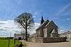
| The Notre-Dame de l'Assomption church, cemetery and surrounding walls (nl) (fr) |
Doische | 50°07′03″N 4°42′04″E / 50.117573°N 4.701212°E |
93018-CLT-0004-01 Info |
 | ||
| The church of Sainte-Colombe (nl) (fr) |
Doische | 50°11′15″N 4°44′11″E / 50.187381°N 4.736258°E |
93018-CLT-0005-01 Info |
|||
| The church of Sainte-Colombe and its surroundings (nl) (fr) |
Doische | 50°11′14″N 4°44′10″E / 50.187161°N 4.735977°E |
93018-CLT-0006-01 Info |
|||
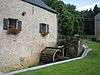
| The old mill and its surroundings (nl) (fr) |
Doische | 50°11′00″N 4°44′32″E / 50.183269°N 4.742253°E |
93018-CLT-0007-01 Info |
|||
| The works upstream and downstream of the mill Soulme (nl) (fr) |
Doische | 50°11′03″N 4°44′33″E / 50.184095°N 4.742431°E |
93018-CLT-0008-01 Info |
 | ||
| The Prèle mill and its surroundings (nl) (fr) |
Doische | 50°11′33″N 4°45′00″E / 50.192424°N 4.750004°E |
93018-CLT-0009-01 Info |
|||
| All archaeological finds, ruins and the surroundings of the Gallo-Roman site called Tienne de Noël " (nl) (fr) |
Doische | 50°06′36″N 4°35′37″E / 50.109907°N 4.593572°E |
93018-CLT-0010-01 Info |
|||
| The chapel "Bonne Fontaine" and its surroundings on the Vodelée <sup style="text-align:right; line-height:1em;
margin-left:0.3em; color:blue; cursor:help; font-family:Verdana,sans-serif;"
title="De kapel "Bonne Fontaine" en haar omgeving aan het Vodelée">(nl) (fr) |
Doische | 50°10′41″N 4°43′25″E / 50.178074°N 4.723627°E |
93018-CLT-0011-01 Info |
|||
| Area of special value of the river Bacquet (source) (nl) (fr) |
Doische | 50°08′42″N 4°47′18″E / 50.145125°N 4.788380°E |
93018-CLT-0012-01 Info |
See also
| Wikimedia Commons has media related to Cultural heritage monuments in Doische. |
References
- Belgian heritage register: Direction générale opérationnelle - Aménagement du territoire, Logement, Patrimoine et Energie (DG4)
- www.dglive.be
This article is issued from Wikipedia - version of the 8/4/2015. The text is available under the Creative Commons Attribution/Share Alike but additional terms may apply for the media files.