List of protected heritage sites in Florenville
This table shows an overview of the protected heritage sites in the Walloon town Florenville. This list is part of Belgium's national heritage.
| Object |
Year/architect |
Town/section |
Address |
Coordinates |
Number? |
Image |
|---|---|---|---|---|---|---|
| The facades and roofs of the main house and outbuildings of the farm Guerlot (nl) (fr) |
Florenville | rue de Margny n°53, te Florenville | 49°37′06″N 5°20′02″E / 49.618462°N 5.333765°E |
85011-CLT-0002-01 Info |
||
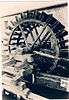
| Watermill of Lacuisine (nl) (fr) |
Florenville | Lacuisine | 49°42′41″N 5°19′23″E / 49.711414°N 5.322936°E |
85011-CLT-0003-01 Info |
 | |
| Site of "Bois de la Rochette" <sup style="text-align:right; line-height:1em;
margin-left:0.3em; color:blue; cursor:help; font-family:Verdana,sans-serif;"
title="Siter van "Bois de la Rochette"">(nl) (fr) |
Florenville | Lacuisine | 49°43′07″N 5°19′11″E / 49.718504°N 5.319741°E |
85011-CLT-0004-01 Info |
||
| A part of the descent between the rocks of du Hat, du Rehat and des Rousses (nl) (fr) |
Florenville | 49°44′36″N 5°19′05″E / 49.743449°N 5.318129°E |
85011-CLT-0005-01 Info |
|||
| Croix de Justice (nl) (fr) |
Florenville | Martué | 49°42′41″N 5°18′13″E / 49.711284°N 5.303505°E |
85011-CLT-0006-01 Info |
||
| Ensemble of Roche à l'Appel (nl) (fr) |
Florenville | Muno | 49°44′04″N 5°10′54″E / 49.734524°N 5.181556°E |
85011-CLT-0007-01 Info |
||
| Ensemble of the site of Conques in the territory of the municipality of Sainte-Cecile (nl) (fr) |
Florenville | Sainte-Cecile | 49°46′04″N 5°14′52″E / 49.767725°N 5.247880°E |
85011-CLT-0008-01 Info |
||
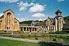
| Ruins of the Abbey of Orval (nl) (fr) |
Florenville | Villers-devant-Orval | 49°38′23″N 5°20′52″E / 49.639606°N 5.347792°E |
85011-CLT-0009-01 Info |
 | |
| Old forge Villers-devant-Orval in Florenville and ensemble formed by the forge and the surrounding land (nl) (fr) |
Florenville | 49°38′00″N 5°20′48″E / 49.633458°N 5.346775°E |
85011-CLT-0010-01 Info |
|||
| All existing buildings in Forge Roussel Florenville (with the exception of a small building) and the retaining walls that are part of the whole and most traces of former buildings and the ensemble of various buildings and surrounding grounds (nl) (fr) |
Florenville | 49°43′47″N 5°18′09″E / 49.729733°N 5.302385°E |
85011-CLT-0011-01 Info |
|||
| The facades, roof and woodwork of "La Poivrière" and the ensemble of the lower part of the church Florenville on the Sambre <sup style="text-align:right; line-height:1em;
margin-left:0.3em; color:blue; cursor:help; font-family:Verdana,sans-serif;"
title="De gevels, dak en timmerwerk van "La Poivrière", en het ensemble van het lager gelegen deel dan de kerk van Florenville langs de Semois">(nl) (fr) |
Florenville | rue de la Culée 20, Florenville | 49°42′07″N 5°18′35″E / 49.701846°N 5.309755°E |
85011-CLT-0012-01 Info |
||
| Ensemble "Lacou", "Aux Chenevières" and the Sambre, in Lacuisine <sup style="text-align:right; line-height:1em;
margin-left:0.3em; color:blue; cursor:help; font-family:Verdana,sans-serif;"
title="Ensemble van "Lacou", "Aux Chénevières" en de Semois, te Lacuisine">(nl) (fr) |
Florenville | 49°42′38″N 5°18′13″E / 49.710423°N 5.303680°E |
85011-CLT-0013-01 Info |
|||
| The old quarter of the old priory of Muno in Florenville, the two adjacent buildings at right angles to the northwest of the courtyard and the combination of the priory and its surroundings (nl) (fr) |
Florenville | 49°42′41″N 5°10′36″E / 49.711362°N 5.176668°E |
85011-CLT-0015-01 Info |
|||
| Ensemble Epioux castle and surrounding grounds, and the three ponds along the creek Epioux, the brook Eplatis and their confluence (nl) (fr) |
Florenville | 49°46′05″N 5°18′01″E / 49.767964°N 5.300310°E |
85011-CLT-0016-01 Info |
|||
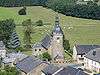
| St. Martin's Church, interior and exterior, and the surrounding wall, the presbytery: interior and exterior, and the ruins of the mill next to Chassepierre, the ensemble formed by these monuments and their surroundings and the caves of crons and a protection (nl) (fr) |
Florenville | 49°42′26″N 5°15′46″E / 49.707312°N 5.262752°E |
85011-CLT-0018-01 Info |
 | ||
| The totality of interior and exterior of the chapel of Saint-Roch, a protection formed by the space with rue de Martué (nl) (fr) |
Florenville | Martué | 49°42′45″N 5°18′15″E / 49.712399°N 5.304073°E |
85011-CLT-0019-01 Info |
||
| Abbey Ruins Orval (nl) (fr) |
Florenville | 49°38′23″N 5°20′52″E / 49.639606°N 5.347792°E |
85011-PEX-0001-01 Info |
 |
See also
| Wikimedia Commons has media related to Cultural heritage monuments in Florenville. |
References
- Belgian heritage register: Direction générale opérationnelle - Aménagement du territoire, Logement, Patrimoine et Energie (DG4)
- www.dglive.be