List of protected heritage sites in Kelmis
This table shows an overview of the protected heritage sites in the Walloon town Kelmis. This list is part of Belgium's national heritage.
| Object |
Year/architect |
Town/section |
Address |
Coordinates |
Number? |
Image |
|---|---|---|---|---|---|---|
| Emmaburg or Eyneburg (nl) (de) |
Kelmis | 50°42′19″N 6°00′57″E / 50.705355°N 6.015762°E |
63040-CLT-0001-01 Info |
.JPG) | ||
| Lontzenerbachtal (nl) (de) |
Kelmis | 50°41′44″N 5°59′33″E / 50.695622°N 5.992558°E |
63040-CLT-0002-01 Info |
 | ||
| Hirtz house (nl) (de) |
Kelmis | 50°42′16″N 5°59′12″E / 50.704431°N 5.986754°E |
63040-CLT-0003-01 Info |
 | ||
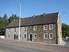
| house (nl) (de) |
Kelmis | Bauweg 75 | 50°43′19″N 6°00′19″E / 50.722016°N 6.005337°E |
63040-CLT-0004-01 Info |
.JPG) | |
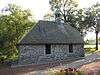
| St. Rochus Chapel and surrounding area (nl) (de) |
Kelmis | 50°42′25″N 6°00′09″E / 50.706891°N 6.002416°E |
63040-CLT-0005-01 Info |
 | ||
| Casno pond (nl) (de) |
Kelmis | 50°42′37″N 6°00′40″E / 50.710157°N 6.011066°E |
63040-CLT-0006-01 Info |
 | ||
| Häuser Penning <sup style="text-align:right; line-height:1em;
margin-left:0.3em; color:blue; cursor:help; font-family:Verdana,sans-serif;"
title="delen van de "Häuser Penning", Lütticher Strasse 241 en 243">(nl) (de) |
Kelmis | Lütticher Strasse 241-243 | 50°42′46″N 6°00′41″E / 50.712701°N 6.011342°E |
63040-CLT-0007-01 Info |
 |
See also
References
| Wikimedia Commons has media related to Cultural heritage monuments in. |
- Belgian heritage register: Direction générale opérationnelle - Aménagement du territoire, Logement, Patrimoine et Energie (DG4)
- www.dglive.be
This article is issued from Wikipedia - version of the 10/28/2015. The text is available under the Creative Commons Attribution/Share Alike but additional terms may apply for the media files.