List of protected heritage sites in La Hulpe
This table shows an overview of the protected heritage sites in the Walloon town Terhulpen, or La Hulpe. This list is part of Belgium's national heritage.
| Object |
Year/architect |
Town/section |
Address |
Coordinates |
Number? |
Image |
|---|---|---|---|---|---|---|
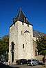
| Tower, high nave and the choir of the church of Saint-Nicolas in La Hulpe (nl) (fr) |
Terhulpen | 50°43′53″N 4°29′26″E / 50.731388°N 4.490532°E |
25050-CLT-0001-01 Info |
 | ||
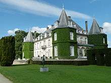
| Domaine Solvay in La Hulpe (nl) (fr) |
Terhulpen | 50°44′44″N 4°26′44″E / 50.745536°N 4.445498°E |
25050-CLT-0002-01 Info |
_1a.jpg) | ||
| Ensemble of the domain "Longfond", in La Hulpe <sup style="text-align:right; line-height:1em;
margin-left:0.3em; color:blue; cursor:help; font-family:Verdana,sans-serif;"
title="Ensemble van het domein "Longfond", te La Hulpe">(nl) (fr) |
Terhulpen | 50°44′44″N 4°26′44″E / 50.745536°N 4.445498°E |
25050-CLT-0003-01 Info |
 | ||
| Ensemble of the domain Nysdam and surrounding area (nl) (fr) |
Terhulpen | 50°43′37″N 4°27′23″E / 50.726874°N 4.456486°E |
25050-CLT-0004-01 Info |
|||
| Valley of Argentine: flow of the stream and wetlands Gaillemarde over the creek and the ponds, from the road to Brussels up to the road rue F. Dubois, including the large pond Papeteries (nl) (fr) |
Terhulpen | 50°43′21″N 4°26′12″E / 50.722634°N 4.436742°E |
25050-CLT-0006-01 Info |
.JPG) | ||
| Pump Victor Horta, on the Solvay Estate in La Hulpe (nl) (fr) |
Terhulpen | 50°44′00″N 4°27′34″E / 50.733196°N 4.459353°E |
25050-CLT-0007-01 Info |
|||
| Ensemble of the Soignes forest and the Bois des Capucins in the territory of the municipalities Auderghem, Duisbourg, Hoeilaart, La Hulpe, Rhode-Saint Genèse, Tervuren, Uccle, Waterloo, Watermael Boitsfort and Woluwe-Saint-Pierre (nl) (fr) |
Terhulpen | 50°43′48″N 4°25′10″E / 50.729909°N 4.419371°E |
25050-CLT-0008-01 Info |
|||
| The domain of Solvay (nl) (fr) |
Terhulpen | 50°44′44″N 4°26′44″E / 50.745536°N 4.445498°E |
25050-PEX-0001-01 Info |
.JPG) | ||
| Ensemble of the domain Nysdam and surrounding area (nl) (fr) |
Terhulpen | 50°43′37″N 4°27′23″E / 50.726874°N 4.456486°E |
25050-PEX-0002-01 Info |
|||
| Soignes forest area (nl) (fr) |
Terhulpen | 50°43′48″N 4°25′10″E / 50.729909°N 4.419371°E |
25050-PEX-0003-01 Info |
See also
| Wikimedia Commons has media related to Cultural heritage monuments in La Hulpe. |
References
- Belgian heritage register: Direction générale opérationnelle - Aménagement du territoire, Logement, Patrimoine et Energie (DG4)
- www.dglive.be
This article is issued from Wikipedia - version of the 11/11/2015. The text is available under the Creative Commons Attribution/Share Alike but additional terms may apply for the media files.