List of protected heritage sites in Nivelles
This table shows an overview of the protected heritage sites in the Walloon town Nijvel, or Nivelles. This list is part of Belgium's national heritage.
| Object |
Year/architect |
Town/section |
Address |
Coordinates |
Number? |
Image |
|---|---|---|---|---|---|---|
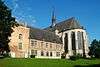
| Chapel of Récollets (nl) (fr) |
Nijvel | 50°35′46″N 4°19′40″E / 50.596238°N 4.327793°E |
25072-CLT-0001-01 Info |
 | ||
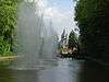
| Park Dodaine (nl) (fr) |
Nijvel | 50°35′29″N 4°19′14″E / 50.591474°N 4.320543°E |
25072-CLT-0003-01 Info |
 | ||
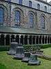
| Cloister of the former convent of Saint Gertrude (nl) (fr) |
Nijvel | 50°35′52″N 4°19′25″E / 50.597721°N 4.323523°E |
25072-CLT-0004-01 Info |
 | ||
| Cellars of the Collegiate Church of Sainte-Gertrude (nl) (fr) |
Nijvel | 50°35′52″N 4°19′24″E / 50.597894°N 4.323386°E |
25072-CLT-0005-01 Info |
|||
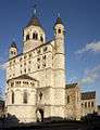
| Collegiate Church of Saint Gertrude (nl) (fr) |
Nijvel | 50°35′51″N 4°19′25″E / 50.597440°N 4.323700°E |
25072-CLT-0006-01 Info |
 | ||
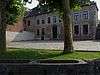
| town hall (nl) (fr) |
Nijvel | 50°35′52″N 4°19′22″E / 50.597820°N 4.322820°E |
25072-CLT-0007-01 Info |
|||
| Fontaine-Perron <sup style="text-align:right; line-height:1em;
margin-left:0.3em; color:blue; cursor:help; font-family:Verdana,sans-serif;"
title=""Fontaine-Perron"">(nl) (fr) |
Nijvel | 50°35′49″N 4°19′23″E / 50.596937°N 4.323013°E |
25072-CLT-0008-01 Info |
|||
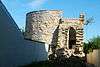
| tower Simone (nl) (fr) |
Nijvel | 50°35′48″N 4°19′11″E / 50.596732°N 4.319676°E |
25072-CLT-0009-01 Info |
 | ||
| Building "La Tourette" <sup style="text-align:right; line-height:1em;
margin-left:0.3em; color:blue; cursor:help; font-family:Verdana,sans-serif;"
title="Gebouw "La Tourette"">(nl) (fr) |
Nijvel | 50°35′34″N 4°19′08″E / 50.592670°N 4.318794°E |
25072-CLT-0010-01 Info |
 | ||
| building (nl) (fr) |
Nijvel | rue de Bruxelles 29 | 50°35′58″N 4°19′28″E / 50.599477°N 4.324407°E |
25072-CLT-0011-01 Info |
||
| Renard tower (nl) (fr) |
Nijvel | 50°35′33″N 4°19′59″E / 50.592460°N 4.332932°E |
25072-CLT-0012-01 Info |
|||
| Old farm of Quertaimont (nl) (fr) |
Nijvel | 50°36′11″N 4°19′55″E / 50.603035°N 4.331847°E |
25072-CLT-0013-01 Info |
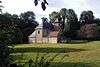 | ||
| Domain Fonteneau (nl) (fr) |
Nijvel | 50°36′33″N 4°19′57″E / 50.609250°N 4.332579°E |
25072-CLT-0015-01 Info |
|||
| Domain of Potte (nl) (fr) |
Nijvel | 50°36′44″N 4°20′02″E / 50.612206°N 4.333964°E |
25072-CLT-0016-01 Info |
|||
| Forest of Sépulcre (nl) (fr) |
Nijvel | 50°36′45″N 4°18′22″E / 50.612478°N 4.306235°E |
25072-CLT-0017-01 Info |
|||
| Facades, roof, cladding and staircases of the building (nl) (fr) |
Nijvel | rue des Saintes n° 16 | 50°35′45″N 4°19′34″E / 50.595751°N 4.326214°E |
25072-CLT-0018-01 Info |
||
| Facades and roofs of the building n° 98 located near Charleroi (nl) (fr) |
Nijvel | n° 98 | 50°35′25″N 4°19′47″E / 50.590290°N 4.329650°E |
25072-CLT-0019-01 Info |
||
| Property and construction (nl) (fr) |
Nijvel | rue de la religion n° 10 | 50°35′43″N 4°19′36″E / 50.595374°N 4.326708°E |
25072-CLT-0021-01 Info |
 | |
| Church of Sainte-Marguerite, with the exception of the small shrine on the right side of the building, and the group formed by the church, the cemetery, the rectory and the garden and the road along the wall of the farm (nl) (fr) |
Nijvel | 50°35′52″N 4°22′06″E / 50.597771°N 4.368336°E |
25072-CLT-0022-01 Info |
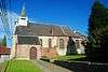 | ||
| Church of Saint Francis (nl) (fr) |
Nijvel | 50°36′06″N 4°16′30″E / 50.601670°N 4.274927°E |
25072-CLT-0023-01 Info |
 | ||
| Facades and roofs of the main building and the pavilion (nl) (fr) |
Nijvel | rue de Soignies n° 15 | 50°35′49″N 4°19′15″E / 50.597030°N 4.320718°E |
25072-CLT-0024-01 Info |
||
| Presbytery: facades and roofs (nl) (fr) |
Nijvel | rue du Centre n° 40 | 50°36′05″N 4°16′29″E / 50.601483°N 4.274618°E |
25072-CLT-0025-01 Info |
 | |
| Farm of Seigneur: facades and roofs of the old 17th century entrance, the facade, roof and gable of the south wing of the old outbuildings (nl) (fr) |
Nijvel | 50°36′01″N 4°16′19″E / 50.600321°N 4.272022°E |
25072-CLT-0026-01 Info |
 | ||
| The organ and choir screen, surrounding walls and ceiling of the first span of the church Saint-Remy (nl) (fr) |
Nijvel | 50°36′47″N 4°21′06″E / 50.613017°N 4.351780°E |
25072-CLT-0027-01 Info |
 | ||
| Forest of Hôpital (nl) (fr) |
Nijvel | 50°35′32″N 4°15′49″E / 50.592154°N 4.263528°E |
25072-CLT-0031-01 Info |
|||
| Forest of Arpes (nl) (fr) |
Nijvel | 50°34′38″N 4°16′47″E / 50.577098°N 4.279806°E |
25072-CLT-0032-01 Info |
|||
| Ensemble of Collegiate Church of Sainte Gertrude, with the exception of the front part of the furnishings (except the pulpit) and organ (instrumental part and buffet) (nl) (fr) |
Nijvel | 50°35′51″N 4°19′25″E / 50.597440°N 4.323700°E |
25072-PEX-0001-01 Info |
 |
See also
| Wikimedia Commons has media related to Cultural heritage monuments in Nivelles. |
References
- Belgian heritage register: Direction générale opérationnelle - Aménagement du territoire, Logement, Patrimoine et Energie (DG4)
- www.dglive.be