List of protected heritage sites in Orp-Jauche
This table shows an overview of the protected heritage sites in the Walloon town Orp-Jauche. This list is part of Belgium's national heritage.
| Object |
Year/architect |
Town/section |
Address |
Coordinates |
Number? |
Image |
|---|---|---|---|---|---|---|
| The farm Le Cerf ou Hicquet and surrounding area (nl) (fr) |
Orp-Jauche | 50°39′27″N 4°58′40″E / 50.657570°N 4.977776°E |
25120-CLT-0001-01 Info |
|||
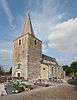
| Church of Saint-Pierre (nl) (fr) |
Orp-Jauche | 50°40′27″N 4°58′46″E / 50.674173°N 4.979341°E |
25120-CLT-0002-01 Info |
 | ||
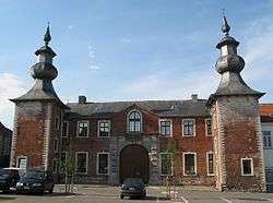
| The facade and two towers of the castle of Jauche (nl) (fr) |
Orp-Jauche | 50°40′55″N 4°57′19″E / 50.681812°N 4.955240°E |
25120-CLT-0003-01 Info |
 | ||
| Tower at the entrance of the house (nl) (fr) |
Orp-Jauche | rue de la Cure n°11 | 50°40′54″N 4°57′11″E / 50.681563°N 4.952930°E |
25120-CLT-0004-01 Info |
||
| St. Martin's Church (nl) (fr) |
Orp-Jauche | 50°42′27″N 4°57′11″E / 50.707572°N 4.953006°E |
25120-CLT-0005-01 Info |
 | ||
| Church of Saints-Martin-et-Adele (nl) (fr) |
Orp-Jauche | 50°42′12″N 4°59′29″E / 50.703243°N 4.991252°E |
25120-CLT-0006-01 Info |
| ||
| Choir and sacristy of the chapel of Notre-Dame (nl) (fr) |
Orp-Jauche | 50°42′02″N 4°58′54″E / 50.700651°N 4.981759°E |
25120-CLT-0007-01 Info |
|||
| Caves of Folx-les-Caves and surrounding area (nl) (fr) |
Orp-Jauche | 50°40′01″N 4°56′20″E / 50.666934°N 4.938891°E |
25120-CLT-0008-01 Info |
|||
| The old underground quarries of Folx-les-Caves (nl) (fr) |
Orp-Jauche | 50°40′01″N 4°56′20″E / 50.666934°N 4.938891°E |
25120-PEX-0001-01 Info |
See also
| Wikimedia Commons has media related to Cultural heritage monuments in Orp-Jauche. |
References
- Belgian heritage register: Direction générale opérationnelle - Aménagement du territoire, Logement, Patrimoine et Energie (DG4)
- www.dglive.be
This article is issued from Wikipedia - version of the 5/12/2016. The text is available under the Creative Commons Attribution/Share Alike but additional terms may apply for the media files.