List of protected heritage sites in Philippeville
This table shows an overview of the protected heritage sites in the Walloon town Philippeville. This list is part of Belgium's national heritage.
| Object |
Year/architect |
Town/section |
Address |
Coordinates |
Number? |
Image |
|---|---|---|---|---|---|---|
| Church of Saint-Philippe (nl) (fr) |
Philippeville | 50°11′46″N 4°32′43″E / 50.196036°N 4.545394°E |
93056-CLT-0001-01 Info |
 | ||
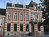
| Town hall (nl) (fr) |
1877 | Philippeville | 50°11′47″N 4°32′33″E / 50.196355°N 4.542567°E |
93056-CLT-0002-01 Info |
 | |
| Ruins of the feudal castle of Fagnolle (nl) (fr) |
Fagnolle Philippeville | 50°06′34″N 4°33′56″E / 50.109409°N 4.565538°E |
93056-CLT-0003-01 Info |
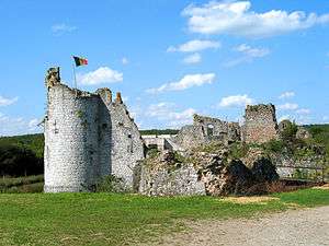 | ||
| Ensemble, consisting of feudal castle ruins Fagnolle, the gatehouse and surrounding areas (nl) (fr) |
Fagnolle Philippeville | 50°06′33″N 4°33′53″E / 50.109253°N 4.564745°E |
93056-CLT-0004-01 Info |
| ||
| Ruins of the feudal castle of Fagnolle: the gatehouse, outer walls and inner walls of the moat, turrets and the two columns on either side of the entrance outside the castle and the ensemble of the ruins of the castle and surrounding area (nl) (fr) |
Fagnolle Philippeville | 50°06′33″N 4°33′57″E / 50.109124°N 4.565824°E |
93056-CLT-0005-01 Info |
_449.JPG) | ||
| Vicarage, former home of the sheriff (nl) (fr) |
Philippeville | rue du Bailli n°18 | 50°06′20″N 4°34′22″E / 50.105578°N 4.572845°E |
93056-CLT-0006-01 Info |
_445.JPG) | |
| Castle farm (nl) (fr) |
Roly Philippeville | place de Roly n°8 | 50°08′05″N 4°32′16″E / 50.134779°N 4.537698°E |
93056-CLT-0008-01 Info |
 | |
| Church of Saint-Denis (nl) (fr) |
Philippeville | 50°08′08″N 4°32′23″E / 50.135473°N 4.539834°E |
93056-CLT-0009-01 Info |
_136.JPG) | ||
| Chapel of Saint-Medard in the 17th century (nl) (fr) |
Samart Philippeville | Samart | 50°10′40″N 4°32′04″E / 50.177806°N 4.534449°E |
93056-CLT-0010-01 Info |
 | |
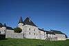
| Castle Samart: facades, roofs and interiors, and buildings: facades and roofs. (nl) (fr) |
Philippeville | 50°10′41″N 4°32′05″E / 50.177935°N 4.534766°E |
93056-CLT-0011-01 Info |
_050.JPG) | ||
| Castle Samart: northern and eastern buildings (facades and roofs) and the surrounding wall north and east, and the ensemble of these structures and the surrounding areas (nl) (fr) |
Philippeville | 50°10′42″N 4°32′07″E / 50.178200°N 4.535345°E |
93056-CLT-0013-01 Info |
_162.JPG) | ||
| Stone "Aux Sacrifices" and its surroundings, at a place called "Tienne Fagnes" <sup style="text-align:right; line-height:1em;
margin-left:0.3em; color:blue; cursor:help; font-family:Verdana,sans-serif;"
title="Steen "Aux Sacrifices" en zijn omgeving, op een plaats genaamd "Tienne des Fagnes"">(nl) (fr) |
Philippeville | 50°06′32″N 4°35′13″E / 50.108756°N 4.587057°E |
93056-CLT-0014-01 Info |
|||
| Bunch of Marmont (nl) (fr) |
Philippeville | 50°10′25″N 4°40′08″E / 50.173479°N 4.668967°E |
93056-CLT-0015-01 Info |
|||
| Castle farm small tower with "loopholes" (shooting slits) to the left of the main entrance (nl) (fr) |
Philippeville | 50°10′27″N 4°31′16″E / 50.174304°N 4.520996°E |
93056-CLT-0016-01 Info |
 | ||
| "Caserne des Fours": facades, roofs and cladding and the ensemble of the internal walkways <sup style="text-align:right; line-height:1em;
margin-left:0.3em; color:blue; cursor:help; font-family:Verdana,sans-serif;"
title=""Caserne des Fours": gevels, daken en bekleding en het ensemble van de Caserne en de interne omloop">(nl) (fr) |
Philippeville | 50°11′43″N 4°32′39″E / 50.195154°N 4.544110°E |
93056-CLT-0017-01 Info |
|||
| The walls of the village Sautour and buildings located within them, setting conservation (nl) (fr) |
Philippeville | 50°10′12″N 4°33′27″E / 50.170102°N 4.557503°E |
93056-CLT-0018-01 Info |
|||
| Ruins of the walls of Sautour and gate known as a Roman gate (nl) (fr) |
Philippeville | 50°10′16″N 4°33′33″E / 50.171017°N 4.559112°E |
93056-CLT-0019-01 Info |
|||
| Chapel of Notre-Dame des Remparts (nl) (fr) |
Philippeville | 50°11′51″N 4°32′53″E / 50.197455°N 4.548075°E |
93056-CLT-0022-01 Info |
|||
| Washing place and the ensemble of the washing place with the surrounding area (nl) (fr) |
Philippeville | rue de Fagnolle | 50°06′16″N 4°34′03″E / 50.104436°N 4.567371°E |
93056-CLT-0024-01 Info |
_IMG_0493.JPG) | |
| St. Martin's Church and walls of the cemetery, and the ensemble of the church and its surroundings, except for the garage at n ° 173 B, and part of the rue de Fagnolle, rue de la Foire and rue du Bailli (nl) (fr) |
Fagnolle Philippeville | 50°06′18″N 4°34′13″E / 50.105100°N 4.570307°E |
93056-CLT-0025-01 Info |
 | ||
| The statue of Queen Louise-Marie (nl) (fr) |
Philippeville | place d'Armes | 50°11′46″N 4°32′37″E / 50.196232°N 4.543525°E |
93056-CLT-0028-01 Info |
||
| Old hospital of the barracks: facades and roofs (nl) (fr) |
Philippeville | rue de l'Hôpital n°6 | 50°11′49″N 4°32′38″E / 50.196900°N 4.543794°E |
93056-CLT-0029-01 Info |
||
| Farm of Vieux-Sautour: facades and roofs, and the surrounding walls (nl) (fr) |
Philippeville | 50°09′57″N 4°34′30″E / 50.165830°N 4.575043°E |
93056-CLT-0030-01 Info |
|||
| Infantry Barracks adjacent to the courtyard of the Cavaliers and the establishment of a protection zone (nl) (fr) |
Philippeville | 50°11′43″N 4°32′32″E / 50.195393°N 4.542191°E |
93056-CLT-0031-01 Info |
|||
| Pump (nl) (fr) |
Philippeville | rue du Quartier Brûlé | 50°11′45″N 4°32′25″E / 50.195848°N 4.540263°E |
93056-CLT-0032-01 Info |
||
| House: walls and roofs (nl) (fr) |
Philippeville | rue de France n°s 17, 19, 21, 23, 25, 27, 29 en 31 | 50°11′46″N 4°32′26″E / 50.196113°N 4.540446°E |
93056-CLT-0034-01 Info |
||
| Totality of the church of Saint-Jean Baptiste (nl) (fr) |
Philippeville | 50°10′28″N 4°31′17″E / 50.174482°N 4.521307°E |
93056-CLT-0035-01 Info |
|||
| Archaeological remains at a place called "Les Machenees" and the ensemble of the site and surrounding area. Establishment of a protection zone. <sup style="text-align:right; line-height:1em;
margin-left:0.3em; color:blue; cursor:help; font-family:Verdana,sans-serif;"
title="Archeologische resten op een plaats genaamd "Les Machenées" en het ensemble van de plek en de omliggende terreinen. Oprichting van een beschermingszone.">(nl) (fr) |
Philippeville | 50°11′01″N 4°31′14″E / 50.183721°N 4.520684°E |
93056-CLT-0036-01 Info |
|||
| Roly Village (nl) (fr) |
Roly Philippeville | 50°08′10″N 4°32′23″E / 50.136225°N 4.539837°E |
93056-CLT-0039-01 Info |
 |
See also
| Wikimedia Commons has media related to Cultural heritage monuments in Philippeville. |
References
- Belgian heritage register: Direction générale opérationnelle - Aménagement du territoire, Logement, Patrimoine et Energie (DG4)
- www.dglive.be