List of rivers and water bodies of Montreal Island
The rivers and water bodies of Montreal are few and mostly artificial. Hydrography of the island of Montreal remained intact until approximately XIXth where Montreal will undergo major urban works including the construction of Lachine Canal and the creation of the first major parks of Montreal.
History
Last Ice Age
After the Ice Age, around -13 000 years, Montreal and the Saint Lawrence Lowlands are flooded by the Champlain sea. Within a few centuries, as and when these waters recede, the Mount Royal and its three summits are emerged into islands. With the complete withdrawal of the sea, water is retained in some depression of the island. This is the case among other Beaver Lake, located in the palm of Mount Royal. This will dry gradually to become a fen.[1] He was regrooved artificially in 1938.
Before XIXth

There used to be a complex hydrographic, now destroyed or channeled[2] · .[3]
- Lake Otter (or small lake St. Peter): long by about 4 kilometers and one kilometer wide, marshy lake that was half way between the Old Montreal and Lachine, south of Quartier Latin, the Saint-Jacques escarpment, and west of the Turcot Interchange. It was backfilled and gradually dried up, particularly with the construction of the Lachine Canal and with the industrialization of the sector. The highway 20 runs through the length and breadth of today in the center.[4]
- Saint-Pierre River: started in Côte-des-Neiges down to Notre-Dame-de-Grâce and widening formed Lake Otter. It then returns to the river and leads to St. Lawrence River in Nuns' Island.
- Little St. Pierre River: created artificially in 1697 under the name of "St. Gabriel canal". This channel connects the Saint-Pierre River (in the east part of Lake Otter) up the Pointe-à-Callière Museum. One part was channeled as qu'égout (William collector) in 1832. The Pointe-à-Callière Museum would make the public place around 2017.[5]
- Saint Martin River or Little River: It begins at Mount Royal Cemetery through Outremont, Quebec and the Mile End and Plateau Mont-Royal until La Fontaine Park (including the pond is a remnant). Then it branched off westward through the Quartier Latin and ran along the Montreal fortifications to the river. There are still some traces of the river.[6]
Today
Today there are only a handful of streams and lakes in nature. However, many parks have ponds or artificial lakes of large size.
List of water bodies
Below is a partial list of current waters bodies of the island:
| Name | Photo | Location | Contact information | Type | Area (ha) |
|---|---|---|---|---|---|
| Lachine Canal | 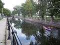 | Montreal | 45°27′39″N 73°36′17″W / 45.4607°N 73.6046°W | artificial | 158 hectares (390 acres) |
| Aqueduct Canal |  | Montreal | 45°26′11″N 73°35′58″W / 45.4363°N 73.5994°W | artificial | |
| Olympic pool |  | Jean-Drapeau Park | 45°30′32″N 73°31′26″W / 45.5089°N 73.5238°W | artificial | 24 hectares (59 acres) |
| Lake Île Notre-Dame |  | Jean-Drapeau Park | 45°30′08″N 73°31′31″W / 45.5023°N 73.5253°W | artificial | 14 hectares (35 acres) |
| Centennial Lake |  | Dollard-Des Ormeaux | 45°29′12″N 73°48′51″W / 45.4868°N 73.8143°W | artificial | 9.8 hectares (24 acres) |
| Lac des Dauphins | 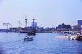 | Jean-Drapeau Park | 45°31′27″N 73°32′11″W / 45.5241°N 73.5364°W | artificial | 5 hectares (12 acres) |
| Lac des Battures | | Nuns' Island | 45°27′16″N 73°33′17″W / 45.4545°N 73.5546°W | artificial | 5 hectares (12 acres) |
| Main pond Parc Angrignon | 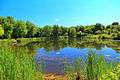 | Angrignon Park | 45°26′35″N 73°36′05″W / 45.4430°N 73.6014°W | artificial | 4.8 hectares (12 acres) |
| Little Basin |  | Parc des Rapides | 45°25′40″N 73°35′29″W / 45.4278°N 73.5914°W | artificial | 3.5 hectares (8.6 acres) |
| Swan Lake |  | Jean-Drapeau Park | 45°30′31″N 73°32′04″W / 45.5087°N 73.5344°W | artificial | 3 hectares (7.4 acres) |
| Pond Fountain |  | Parc La Fontaine | 45°31′29″N 73°34′09″W / 45.5248°N 73.5691°W | artificial | 2.8 hectares (6.9 acres) |
| Beaver Lake | 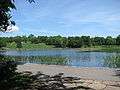 | Mount Royal Park | 45°29′55″N 73°35′51″W / 45.4986°N 73.5974°W | artificial | 1.9 hectares (4.7 acres) |
| Basin Jarry Park | 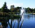 | Jarry Park | 45°32′07″N 73°37′30″W / 45.5353°N 73.6249°W | artificial | 1 hectare (2.5 acres) |
List of rivers
- Rivière à l'Orme
- Bertrand Brook
- Saint-Pierre River (Montreal)
- Lachine Canal
- Aqueduct Canal
- St. Lawrence River
- Prairie River (Montreal)
References
- ↑ Article of "journal Le Devoir" - Beaver Lake (Lac aux Castors) on Mount Royal
- ↑ Radio-Canada
- ↑ sites.google.com Carte des sites de l'héritage autochtone
- ↑ Radio-Canada, emission "Rivières perdues".
- ↑ a-propos de Pointe-à-Callière museum/museum/future-expansion-museum-projects Article "À propos du musée de Pointe-à-Callière"
- ↑ Article "Des rivières perdues - un ruisseau méconnu"
See also
- Blue Network of Montreal
- List of rivers of Quebec
- List of canals of Quebec