List of road routes in the Australian Capital Territory
Road routes in the Australian Capital Territory assist drivers navigating roads. Many major roads in the ACT are not assigned a route number.
Current routes

| Route | Component roads | From | Via (Districts) | To | Length | Notes |
|---|---|---|---|---|---|---|
A23 |
B23 terminus at Capital Hill–Parkes–Yarralumla triple point | ACT–NSW border at Sutton, New South Wales | 14.4 km (8.9 mi)[3] | Continues northeast into NSW as M23 | ||
A25 |
A23 junction at the Lyneham–Downer boundary | ACT–NSW border at Wallaroo, New South Wales | 11.9 km (7.4 mi)[4] | Continues northwest into NSW as A25 | ||
B23 |
A23 terminus at Capital Hill–Parkes–Yarralumla triple point | ACT–NSW border at Williamsdale, New South Wales | 39.0 km (24.2 mi)[5] | Continues south into NSW as B23 | ||
B52 |
|
First Section: B23 junction at the Fyshwick–Symonston boundary Second (Kowen) Section: ACT–NSW border at Carwoola, New South Wales |
|
First Section: ACT–NSW border at Queanbeyan West–Crestwood, New South Wales boundary Second (Kowen) Section: ACT–NSW border at Bungendore, New South Wales |
3.0 km (1.9 mi)[6] 7.5 km (4.7 mi)[7] |
Continues east into NSW as B52 |
Former routes
| Route | Component roads | From | Via (Districts) | To | Length | Notes |
|---|---|---|---|---|---|---|
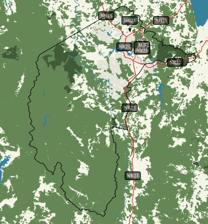
National Highway 23 |
NH25 and NR23 terminus at the Lyneham–Downer boundary | ACT–NSW border at Sutton, New South Wales | 7.1 km (4.4 mi)[9] | Replaced by A23 | ||
National Highway 25 |
NH23 and NR23 terminus at the Lyneham–Downer boundary | ACT–NSW border at Wallaroo, New South Wales | 11.9 km (7.4 mi)[4] | Replaced by A25 | ||
National Route 23 |
NH23 and NH25 terminus at the Lyneham–Downer boundary | ACT–NSW border at Williamsdale, New South Wales | 44.7 km (27.8 mi)[10] | Largely replaced by A23 and B23 | ||
Alternate National Route 23 |
|
NH23 junction at the Gungahlin–Majura district boundary | NR23 junction and NR52 terminus at the Fyshwick–Symonston–Narrabundah triple point |
15.1 km (9.4 mi)[11] | Not replaced | |
National Route 52 |
|
First Section: NR23 junction and ALT NR23 terminus at the Fyshwick–Symonston–Narrabundah triple point Second (Kowen) Section: ACT–NSW border at Carwoola, New South Wales |
|
First Section: ACT–NSW border at Queanbeyan West–Crestwood, New South Wales boundary Second (Kowen) Section: ACT–NSW border at Bungendore, New South Wales |
4.6 km (2.9 mi)[12] 7.5 km (4.7 mi)[7] |
Largely replaced by B52 Replaced by B52 |
See also
References
- ↑ "Implementation stages map – Australian Capital Territory" (PDF). NSW Roads and Maritime Services. April 2013. Retrieved 5 October 2013.
- ↑ RMS admin (16 August 2013). "Have your say – A better way to navigate NSW roads". NSW Roads and Maritime Services. Retrieved 5 October 2013.
- ↑ Google (5 October 2013). "Driving directions to Federal Hwy/M23/National Highway 23" (Map). Google Maps. Google. Retrieved 5 October 2013.
- 1 2 Google (5 October 2013). "Driving directions to Barton Hwy/National Highway 25" (Map). Google Maps. Google. Retrieved 5 October 2013.
- ↑ Google (5 October 2013). "Driving directions to Monaro Hwy/National Route 23" (Map). Google Maps. Google. Retrieved 5 October 2013.
- ↑ Google (5 October 2013). "Driving directions to Canberra Ave/National Route 52" (Map). Google Maps. Google. Retrieved 5 October 2013.
- 1 2 Google (5 October 2013). "Driving directions to Kings Hwy/National Route 52" (Map). Google Maps. Google. Retrieved 5 October 2013.
- ↑ "Trunk Road Infrastructure Standard No .03 – Traffic Management" (PDF). Attachment A – Road Signs. Territory and Municipal Services. October 2012. pp. 7, 18, 24–25. Retrieved 5 October 2013.
- ↑ Google (5 October 2013). "Driving directions to Federal Hwy/M23/National Highway 23" (Map). Google Maps. Google. Retrieved 5 October 2013.
- ↑ Google (5 October 2013). "Driving directions to Monaro Hwy/National Route 23" (Map). Google Maps. Google. Retrieved 5 October 2013.
- ↑ Google (5 October 2013). "Driving directions to Monaro Hwy/National Route Alt 23" (Map). Google Maps. Google. Retrieved 5 October 2013.
- ↑ Google (5 October 2013). "Driving directions to Canberra Ave/National Route 52" (Map). Google Maps. Google. Retrieved 5 October 2013.
This article is issued from Wikipedia - version of the 8/21/2014. The text is available under the Creative Commons Attribution/Share Alike but additional terms may apply for the media files.