List of tallest buildings in Manchester, New Hampshire
Manchester is a city in Hillsborough County in southern New Hampshire, United States. It has a population of over 110,000 people and about 10 skyscrapers. This article is a list of the tallest buildings in Manchester and New Hampshire.
| Rank | Name | Image | Height | Floors | Year | Notes |
|---|---|---|---|---|---|---|
| 1 | City Hall Plaza | 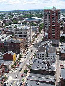 |
275 ft (84 m) | 22 | 1994 | The tallest building in New Hampshire since its completion in 1994, succeeding the Hampshire Plaza (now Brady Sullivan Plaza). The tallest building in New England north of Cambridge, Massachusetts. |
| 2 | Brady Sullivan Plaza | 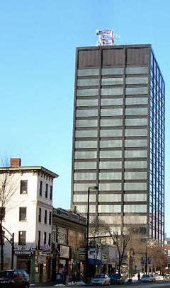 |
259 ft (79 m) | 20 | 1972 | The tallest building in New Hampshire from 1972 until 1994. |
| 3 | Wall Street Apartments | 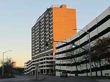 |
223 ft (68 m) | 18 | 1985 | Used to have a restaurant on the top floor. |
| 4 | WZID Tower | 194 ft (59 m) | 5 | 1991 | 194-foot communications tower on top of the WZID Building. | |
| 5 | Radisson Hotel | 187 ft (57 m) | 12 | 1983 | Hotel and residential building. | |
| 6 | Brady Sullivan Tower | 180 ft (55 m) | 14 | 1970 | Briefly was tallest building in New Hampshire. | |
| 7 | Burns High Rise | 161 ft | 13 | Residential. Tallest building on West Side. | ||
| 8 | Carpenter Center | 148 ft (45 m) | 12 | ~1920 | Once the biggest hotel in Manchester. | |
| 9 | Citizens Bank Building | 131 ft (40 m) | 10 | 1913 | Manchester's first high-rise. | |
| 10 | Hampshire Towers | 127 | 12 | 1973 | Condos. | |
| 11 | Pariseau Building | 126 ft (38 m) | 11 | 1973 | Residential. | |
| 12 | O'Malley High Rise | 112 ft (34 m) | 9 | Residential. | ||
| 12 | Kalivas High Rise | 112 ft (34 m) | 9 | Residential. | ||
| 12 | Residences at Manchester Place | 112 ft (34 m) | 9 | 2005 | Residential. | |
| 15 | 1155 Elm Street | 100 ft (30 m) | 8 | 1986 | ||
| 15 | Elliot Hospital | 100 ft (30 m) | 8 | ~300 beds | ||
| 17 | Center of New Hampshire | 92.5 ft (28.2 m) | 7 | 1985 | Attached to Radisson. | |
| 18 | SNHU Arena |  |
92 ft (28 m) | 3 | 2001 | Hockey, concert and basketball arena. |
| 19 | Norris Cotton Federal Building | 87 ft (27 m) | 7 | 1976 | ||
| 19 | Govorner Hugh J. Gallen Apartments | 87 ft (27 m) | 7 | |||
| 19 | Catholic Medical Center | 87 ft (27 m) | 7 | 1978 | 300+ beds | |
| 22 | VA Hospital | 75 ft (23 m) | 6 | 1950 | ||
| 22 | WMUR Building | 75 ft (23 m) | 4 | 1987 | Headquarters for "New Hampshire's Number One News Team". |
Coordinates: 42°59′39.3″N 71°27′56.0″W / 42.994250°N 71.465556°W
This article is issued from Wikipedia - version of the 11/18/2016. The text is available under the Creative Commons Attribution/Share Alike but additional terms may apply for the media files.