List of volcanoes in the Hawaiian – Emperor seamount chain
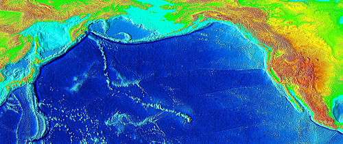
The Hawaiian – Emperor seamount chain is a series of volcanoes and seamounts extending across the Pacific Ocean. The chain has been produced by the movement of the ocean crust over the Hawaiʻi hotspot, an upwelling of hot rock from the Earth's mantle. As the oceanic crust moves the volcanoes farther away from their source of magma, their eruptions become less frequent and less powerful until they eventually cease to erupt altogether. At that point erosion of the volcano and subsidence of the seafloor cause the volcano to gradually diminish. As the volcano sinks and erodes, it first becomes an atoll island and then an atoll. Further subsidence causes the volcano to sink below the sea surface, becoming a seamount and/or a guyot.[1] This list documents the most significant volcanoes in the chain, ordered by distance from the hotspot; however, there are many others that have yet to be properly studied.
The chain can be divided into three subsections. The first, the Hawaiian archipelago (also known as the Windward isles), consists of the islands comprising the U.S. state of Hawaiʻi (not to be confused with the island of Hawaiʻi). As it is the closest to the hotspot, this volcanically active region is the youngest part of the chain, with ages ranging from 400,000 years[2] to 5.1 million years.[3] The island of Hawaiʻi is comprised by five volcanoes, of which two (Kilauea and Mauna Loa) are still active. Lōʻihi Seamount continues to grow offshore, and is the only known volcano in the chain in the submarine pre-shield stage.[1]
The second part of the chain is composed of the Northwestern Hawaiian Islands, collectively referred to as the Leeward isles, the constituents of which are between 7.2 and 27.7 million years in age.[3] Erosion has long since overtaken volcanic activity at these islands, and most of them are atolls, atoll islands, and extinct islands. They contain many of the most northerly atolls in the world; one of them, Kure Atoll, is the northern-most atoll in the world.[4] On June 15, 2006, U.S. President George W. Bush issued a proclamation creating Papahānaumokuākea Marine National Monument under the Antiquities Act of 1906. The national monument, meant to protect the biodiversity of the Hawaiian isles,[n 1] encompasses all of the northern isles, and is one of the largest such protected areas in the world. The proclamation limits tourism to the area, and calls for a phase-out of fishing by 2011.[5]
The oldest and most heavily eroded part of the chain are the Emperor seamounts, which are 39[6] to 85 million years in age.[7] The Emperor and Hawaiian chains are separated by a large L-shaped bend that causes the orientations of the chains to differ by about 60°. This bend was long attributed to a relatively sudden change in the direction of plate motion, but research conducted in 2003 suggests that it was the movement of the hotspot itself that caused the bend.[8] The issue is still currently under debate.[9] All of the volcanoes in this part of the chain have long since subsided below sea level, becoming seamounts and guyots (see also the seamount and guyot stages of Hawaiian volcanism). Many of the volcanoes are named after former emperors of Japan. The seamount chain extends to the West Pacific, and terminates at the Kuril–Kamchatka Trench, a subduction zone at the border of Russia.[10]
Hawaiian archipelago
| Name | Island | Last eruption | Coordinates | Age (years) | Notes | |
|---|---|---|---|---|---|---|
| Lōʻihi Seamount | Seamount | 1996 (active)[2] | 18°32′N 155°16′W / 18.54°N 155.27°W | 400,000[2] | The seamount is a submarine volcano approximately 35 km (22 mi) southeast of Hawaiʻi. It will eventually breach sea level and become the newest Hawaiian island.[2] | |
| Kīlauea | Big Island | Erupting[11] | 19°25′N 155°17′W / 19.417°N 155.283°W | 300,000–600,000[11] | Kīlauea is considered one of the most active volcanoes on Earth.[12]
Puʻu ʻŌʻō, a cinder cone of Kīlauea, has been erupting continuously since January 3, 1983, making it the longest-lived rift-zone eruption of the last six centuries.[13] | |
| Mauna Loa | Big Island | 1984 (active)[14] | 19°28′46.3″N 155°36′09.6″W / 19.479528°N 155.602667°W | 700,000–1 million[15] | Largest volcano on Earth[14] | |
| Hualālai | Big Island | 1801 (active)[16] | 19°41′32″N 155°52′02″W / 19.69222°N 155.86722°W | > 300,000[16] | Lies on the western edge of the Big Island[16] | |
| Mauna Kea | Big Island | 4460 BP (dormant) | 19°49′14.39″N 155°28′05.04″W / 19.8206639°N 155.4680667°W | ~1 million[17] | World's tallest mountain if below-sea elevation is counted[18] | |
| Kohala | Big Island | 120,000 BP (extinct)[19] | 20°05′10″N 155°43′02″W / 20.08611°N 155.71722°W | ~ 120,000–1 million[19] | Oldest volcano that remains part of the island of Hawaiʻi[19] | |
| Māhukona | Seamount | — |
20°01′0″N 156°1′0″W / 20.01667°N 156.01667°W | K-Ar 298,000±25,000 and 310,000±31,000[20][n 2] | Submerged, having long since disappeared into the sea[21] | |
| Haleakalā | Maui | between A.D. 1480 and 1600, oldest currently active volcano in the Hawaiian - Emperor seamount chain[22] | 20°42′35″N 156°15′12″W / 20.70972°N 156.25333°W | ~ 2 million[22] | Forms more than 75% of Maui[22] | |
| West Maui | Maui | — |
20°54′N 156°37′W / 20.900°N 156.617°W | K-Ar 1.32±0.04 million[3] | Very eroded shield volcano that makes up the western quarter of Maui | |
| Kahoʻolawe | Kahoʻolawe | — |
20°33′N 156°36′W / 20.550°N 156.600°W | K-Ar > 1.03±0.18 million[3][23] | Smallest of the 8 principal Hawaiian islands;[19] uninhabited[24] | |
| Lānaʻi | Lānaʻi | — |
20°50′N 156°56′W / 20.833°N 156.933°W | K-Ar date of 1.28±0.04 million[3] | Sixth-largest island[25] The only town is Lānaʻi City, a small settlement. | |
| East Molokai | Molokaʻi | — |
21°7′N 156°51′W / 21.117°N 156.850°W | K-Ar 1.76±0.04 million[3] | The northern half of this volcano suffered a large collapse 1.5 million years ago.[26] Only the southern half remains above the sea today.[19] | |
| West Molokaʻi | Molokaʻi | — |
21°9′N 157°14′W / 21.150°N 157.233°W | K-Ar date of 1.9±0.06 million[3] | ||
| Penguin Bank | Seamount | — |
20°55′N 157°40′W / 20.917°N 157.667°W | ~ 2.2 million[27] | The seamount is a submarine volcano, southwest of Molokaʻi. The submarine volcano used to be part of Maui Nui, a prehistoric island made from seven shield volcanoes. | |
| Koʻolau Range | Oʻahu | — |
21°19′N 157°46′W / 21.317°N 157.767°W | 2.7 million[28] | A fragmented remnant of the eastern or windward shield volcano, which also suffered a large collapse sometime before the Molokaʻi collapse[26] | |
| Waiʻanae Range | Oʻahu | ~1.7 MYA[29] | 21°30′N 158°9′W / 21.500°N 158.150°W | ~1.7–3.9 million; K-Ar 3.7±0.1 million[3][28][29] | The eroded remains of a shield volcano that comprised the western half of the island[29] | |
| Kaʻena Ridge | Oʻahu | <3.0 MYA[30] | 21°42′N 158°22′W / 21.700°N 158.367°W[30] | ~3.5–4.9 million[30] | The eroded remains of a shield volcano west of Waiʻanae that has since subsided below sea level[30] | |
| Kaʻula | Kaʻula | — |
21°39′N 160°32′W / 21.650°N 160.533°W | K-Ar 4.0±0.2 million[3] | Tiny crescent-shaped barren island; uninhabited except for divers and fishermen[31] | |
| Niʻihau | Niʻihau | — |
21°54′N 160°10′W / 21.900°N 160.167°W | K-Ar 4.89±0.11 million[3][32] | Smallest inhabited island;[33] | |
| Kauaʻi | Kauaʻi | — |
22°05′N 159°30′W / 22.083°N 159.500°W | K-Ar 5.1±0.2 million[3][34] | Oldest and fourth largest of the main islands, and home to Mount Waialeale, one of the wettest areas on Earth in terms of precipitation[35] | |
Northwestern Hawaiian islands
| Name | Type | Coordinates | Age[36] | Notes |
|---|---|---|---|---|
| Nihoa | Extinct Island | 23°03′N 161°55′W / 23.050°N 161.917°W | K-Ar 7.2±0.3 million[3] | Small rocky island which supported a small population around 1000 CE; features over 80 cultural sites, including religious places, agricultural terraces, and burial caves[37] |
| Necker Island | Extinct Island | 23°34′35″N 164°42′0″W / 23.57639°N 164.70000°W | K-Ar 10.3±0.4 million[3] | Small deserted island with Hawaiian religious shrines and artifacts[38] |
| French Frigate Shoals | Atoll | 23°52′08″N 166°17′10″W / 23.8689°N 166.2860°W | 12 million[39] | Largest atoll in the northwestern Hawaiian islands[40] |
| Gardner Pinnacles | Atoll Island | 25°01′N 167°59′W / 25.017°N 167.983°W | K-Ar 12.3±1.0 million[3] | Two barren rock outcrops surrounded by a reef[41] |
| Maro Reef | Atoll | 25°25′N 170°35′W / 25.417°N 170.583°W | 12.3 to 19.9 million[n 3] | Largest coral reef of the northwestern Hawaiian islands[42] |
| Laysan | Atoll Island | 25°46′03″N 171°44′00″W / 25.7675°N 171.7334°W | K-Ar 19.9±0.3 million[3] | Originally named "Kauō" meaning egg, referring to its shape, and home to one of only five natural lakes in all of Hawaiʻi[43] |
| Lisianski Island | Atoll Island | 26°3′48.6564″N 173°57′57.346″W / 26.063515667°N 173.96592944°W | 19.9 to 20.6 million[n 3] | A small island surrounded by a huge coral reef nearly the size of Oahu;[44] named after a captain in the Russian navy whose ship ran aground there in 1805[45] |
| Pearl and Hermes Atoll | Atoll Island | 27°48′N 175°51′W / 27.800°N 175.850°W | K-Ar 20.6±2.7 million[3] | A collection of small, sandy islands, with a lagoon and coral reef; named after two whaling ships which were wrecked on the reef in 1822[46] |
| Midway Atoll | Atoll Island | 28°12′N 177°21′W / 28.200°N 177.350°W | K-Ar 27.7±0.6 million[3] | Consists of a ring-shaped barrier reef and two large islets; named "Midway" because of its strategic location in the center of the Pacific Ocean, and was the site of a key battle during World War II[47] |
| Kure Atoll | Atoll | 28°25′N 178°20′W / 28.417°N 178.333°W | 27.7 to 38.7 million[n 3] | Northernmost coral atoll in the world[4] |
Emperor seamounts
Notes
- ↑ All of the islands in this part of the chain are administrated by Hawaii state, save for Midway Atoll, which is administrated by the U.S. Fish and Wildlife Service.
- ↑ The error estimate is given for two standard deviations (95% of data contained within this range). Each of the dates is an average of dates from each of two separate volcanic cones that are part of Māhukona.
- 1 2 3 4 5 6 The age of the volcano is unknown, but will be somewhere between the ages of the volcanoes on either side of it in the chain.
References
- 1 2 "Evolution of Hawaiian Volcanoes". Hawaiian Volcano Observatory (USGS). September 8, 1995. Retrieved March 7, 2009.
- 1 2 3 4 Michael O. Garcia; Jackie Caplan-Auerbanch; Eric H. De Carlo; M.D. Kurz; N. Becker (September 20, 2005). "Geology, geochemistry and earthquake history of Lōʻihi Seamount, Hawaiʻi" (PDF). This is the pre-press version of a paper that was published on 2006-05-16 as "Geochemistry, and Earthquake History of Lōʻihi Seamount, Hawaiʻi's youngest volcano", in Chemie der Erde – Geochemistry (66) 2:81–108. University of Hawaii – School of Ocean and Earth Science and Technology. Bibcode:2006ChEG...66...81G. doi:10.1016/j.chemer.2005.09.002. Retrieved March 20, 2009. Pre-press version
- 1 2 3 4 5 6 7 8 9 10 11 12 13 14 15 16 17 18 19 20 21 22 23 24 25 Rubin, Ken. "The Formation of the Hawaiian Islands". Hawaii Center for Vulcanology. Retrieved May 18, 2009.
- 1 2 "Kure Atoll". Public Broadcasting System – KQED. March 22, 2006. Retrieved June 13, 2009.
- ↑ Staff authors (June 15, 2006). "Bush creates new marine sanctuary". BBC News. Retrieved December 14, 2009.
- 1 2 3 4 5 6 7 8 Sharp, W. D.; Clague, DA (2006). "50-Ma Initiation of Hawaiian-Emperor Bend Records Major Change in Pacific Plate Motion". Science. 313 (5791): 1281–84. Bibcode:2006Sci...313.1281S. doi:10.1126/science.1128489. PMID 16946069.
- 1 2 3 Regelous, M.; Hofmann, A.W.; Abouchami, W.; Galer, S.J.G. (2003). "Geochemistry of Lavas from the Emperor Seamounts, and the Geochemical Evolution of Hawaiian Magmatism from 85 to 42 Ma" (PDF). Journal of Petrology. 44 (1): 113–140. doi:10.1093/petrology/44.1.113. Retrieved July 23, 2010.
- ↑ John Roach (August 14, 2003). "Hot Spot That Spawned Hawaii Was on the Move, Study Finds". National Geographic News. Retrieved March 9, 2009.
- ↑ Sharp et al., 2006, Initiation of the bend near Kimmei seamount about 50 million years ago (MA) was coincident with realignment of Pacific spreading centers and early magmatism in western Pacific arcs, consistent with formation of the bend by changed Pacific plate motion.
- ↑ G. R. Foulger & Don L. Anderson. "The Emperor and Hawaiian Volcanic Chains: How well do they fit the plume hypothesis?". MantlePlumes.org. Retrieved April 1, 2009.
- 1 2 "Kīlauea – Perhaps the World's Most Active Volcano". United States Geological Survey – Hawaiian Volcano Observatory. May 7, 2009. Retrieved May 12, 2009.
- ↑ "Volcano Watch: The most active volcano on Earth?". United States Geological Survey - Hawaiian Volcano Observatory. March 12, 2002. Retrieved December 11, 2011.
- ↑ "The Pu'u 'O'o-Kupaianaha Eruption of Kīlauea Volcano, Hawai'i, 1983 to 2003". United States Geological Survey. December 2, 2002. Retrieved June 7, 2009.
- 1 2 School Specialty Publishing (2006). World Atlas (Illustrated ed.). School Specialty Publishing. p. 13. ISBN 0-7696-4260-8. Retrieved December 13, 2009.
- ↑ "Mauna Loa Earth's Largest Volcano". United States Geological Survey – Hawaiian Volcano Observatory. Retrieved July 3, 2009.
- 1 2 3 "Hualalai: Hawai`i's Third Active Volcano". Other Volcanoes. USGS Hawaiian Volcano Observatory. 18 June 2001. Retrieved 23 January 2010.
- ↑ "Mauna Kea Hawai`i's Tallest Volcano". United States Geological Survey. Retrieved May 14, 2009.
- ↑ Staff authors. "Highest Mountain in the World". Geology.com. Retrieved July 4, 2009.
- 1 2 3 4 5 David R. Sherrod; John M. Sinton; Sarah E. Watkins; Kelly M. Brunt (2007). "USGS Open-File Report 2007–1089 (pamphlet to accompany geologic map)" (PDF). Geological Map of the State of Hawaii. United States Geological Survey. pp. 41–43. Retrieved April 12, 2009.
- ↑ Clague, David A.; Calvert, Andrew T. (2008). "Postshield stage transitional volcanism on Mahukona Volcano, Hawaii". Bulletin of Volcanology. 71 (5): 553–559. Bibcode:2008BVol..tmp...50C. doi:10.1007/s00445-008-0240-z.
- ↑ Clague, D.A. & Moore, J.G. (1991). Geology and Petrology of Mahukona Volcano, Hawaii. 53. Bulletin of Volcanology. pp. 159–172.
- 1 2 3 "East Maui, or Haleakala—A Potentially Hazardous Volcano". United States Geological Survey. February 2003. Retrieved May 13, 2009.
- ↑ "Kahoʻolawe, Hawaii". Photo Gallery of Kahoʻolawe island. Oregon State University. Retrieved April 4, 2009.
- ↑ "Block Group 9, Census Tract 303.02, Maui County, Hawaii". U.S. Census Bureau. 2000.
- ↑ "The State of Hawaii Data Book 2004" (PDF). Hawaii.gov. 2004. Retrieved May 17, 2009.
- 1 2 "Hawaiian Landslides". Monterey Bay Aquarium Research Institute. February 5, 2009. Retrieved June 13, 2009.
- ↑ "Penguin Bank: A Loa-Trend Hawaiian Volcano". American Geophysical Union, Fall Meeting 2007, abstract #V33A-1174. Retrieved January 2, 2014.
- 1 2 "Hawaii's Coastline – Oahu". University of Hawaii – School of Ocean and Earth Science and Technology. Retrieved May 18, 2009.
- 1 2 3 "O'ahu, Ni'ihau, and Kaua'i". United States Geological Survey. September 29, 1995. Retrieved June 13, 2009.
- 1 2 3 4 Sinton, John M.; Eason, Deborah E.; Tardona, Mary; Pyle, Douglas; Zander, Iris van der; Guillou, Hervé; Clague, David; Mahoney, John J. (2 May 2014). "Ka'ena Volcano--A precursor volcano of the island of O'ahu, Hawai'i". Geological Society of America Bulletin. Geological Society of America. doi:10.1130/B30936.1.
- ↑ "Offshore Island Restoration Committee – Kaula". Offshore Island Restoration Committee. Retrieved June 11, 2009.
- ↑ "Hawaii's Coastline – Niihau". University of Hawaii – School of Ocean and Earth Science and Technology. Retrieved May 18, 2009.
- ↑ "Main Hawaiian Islands: Ni'ihau". University of Hawaii – School of Ocean and Earth Science and Technology. Retrieved June 13, 2009.
- ↑ "Hawaii's Coastline – Kauai". University of Hawaii – School of Ocean and Earth Science and Technology. Retrieved May 18, 2009.
- ↑ "Kaua'i". University of Hawaii – School of Ocean and Earth Science and Technology. June 17, 2008. Retrieved June 13, 2009.
- ↑ "The Formation of the Hawaiian Islands". Hawaii Center for Volcanology. Retrieved March 10, 2009.
- ↑ "Nihoa Island". Northwestern Hawaiian Islands Multi-Agency Education Project. Retrieved June 14, 2009.
- ↑ "Necker Island (Mokumanamana)". Northwestern Hawaiian Islands Multi-Agency Education Project. Retrieved June 13, 2009.
- ↑ Darby Dyar (April 22, 2008). "Hotspots and Plate Motion". Mount Holyoke College. Retrieved April 4, 2009.
- ↑ "French Frigate Shoals Reserve Preservation Area" (PDF). National Oceanic and Atmospheric Administration. Retrieved June 13, 2009.
- ↑ "Voyage to Kure: The Northwestern Hawaiian Islands: Gardner Pinnacles". PBS. 22 March 2006. Retrieved 1 May 2010.
- ↑ "Maro Reef (Ko'anako'a)". Northwestern Hawaiian Islands Multi-Agency Education Project. Retrieved June 13, 2009.
- ↑ "Laysan Island". Public Broadcasting System – KQED. March 22, 2006. Retrieved June 13, 2009.
- ↑ "Lisianski Island". Northwestern Hawaiian Islands Multi-Agency Education Project. Retrieved June 14, 2009.
- ↑ "Lisanski Island". Public Broadcasting System – KQED. March 22, 2006. Retrieved June 13, 2009.
- ↑ "Pearl and Hermes Atoll". Public Broadcasting System – KQED. March 22, 2006. Retrieved June 13, 2009.
- ↑ "Midway Atoll". Public Broadcasting System – KQED. March 22, 2006. Retrieved June 13, 2009.
- ↑ "Seamount Catalog". Seamounts database. EarthRef, a National Science Foundation project. Retrieved April 10, 2009.
- ↑ Dalrymple, G.B., Garcia, M.O., Jackson, E.D., Koizumi, I., Avdeiko, G., Butt, A., Clague, D., Greene, H.G., Karpoff, A.M., Kirkpatrick, R.J., Kono, M., Hsin Yi, L., McKenzie, J., Morgan, J. and Takayama, T. (1980). "Age and chemistry of volcanic rocks dredged from Jingu Seamount, Emperor seamount chain". Reports of the Deep Sea Drilling Project 55: 685–693. Retrieved April 4, 2009.
- 1 2 Clague, D. A. and Dalrymple, G. B. (1989) Tectonics, geochronology, and origin of the Hawaiian-Emperor Chain in Winterer, E. L. et al. (editors) (1989) The Eastern Pacific Ocean and Hawaii, Boulder, Geological Society of America, page 199. Accessed July 23, 2010
External links
- This abstract contains preliminary data for several of the seamount dates; these dates are revised in the subsequent paper (as reported above):
- Sharp, W.D.; Clague, D.A. (2002). "An Older, Slower Hawaii-Emperor Bend". AGU Fall Meeting Abstracts. San Francisco, CA: American Geophysical Union. 61: T61C–04. Bibcode:2002AGUFM.T61C..04S.
Hawaiian volcanism topics (list) | ||
|---|---|---|
| Windward Isles |  | |
| Leeward Isles | ||
| Emperor Seamounts | ||
| Topics | ||