Litani River
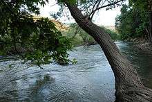
The Litani River (Arabic: نهر الليطاني, Nahr al-Līṭānī), the classical Leontes (Greek: Λέοντες, Léontes, lit. "Lions"), is an important water resource in southern Lebanon. The river rises in the fertile Beqaa Valley, west of Baalbek, and empties into the Mediterranean Sea north of Tyre. Exceeding 140 km in length, the Litani River is the longest river in Lebanon and provides an average annual flow estimated at 920 million cubic meters.[1] The waters of the Litani both originate and flow entirely within the borders of Lebanon. It provides a major source for water supply, irrigation and hydroelectricity both within Southern Lebanon, and the country as a whole.
Sections of its lower reaches were under Israeli control during 1978 and from 1982 to 2000.
Southern flow

After heading south parallel to the Syrian border, as the Litani nears northern Israel, the course of the river bends dramatically westward. Near this bend, the Litani comes within five km of the Hasbani River and four km from the Israeli border.
Qasimiyeh
The portion of the river flowing west is called the Qasimiyeh. The Qasmieh-Ras-el-Aïn region, irrigated from the river's lower reaches from main irrigation canals, to south and north, is one of the largest irrigated areas in the nation, consisting of 32.64 km², shared among 1257 irrigating farmers, who concentrate on citrus crops and bananas (Raad 2004). For the entire stretch of the Qasimiyeh as it flows into the Mediterranean Sea, the Litani River remains nearly parallel to (and about 29 km (18 mi) north of) the Israeli-Lebanese border. 10 km north of Tyre, the river is crossed by the ancient Leontes Bridge. In June 1941, the mouth of the river was the site of an attack by British commandos and Australian troops on Vichy French forces that became known as the Battle of the Litani River.
Litani River Dam
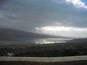
Qaraoun, an artificial lake of 11 square km, was created by the Litani River Dam, 60 meters high and 1,350 meters in length, which was completed in 1959. A spillway of 6503 meters carries the water to the underground station where generators produce a maximum of 185 megawatts of electricity, the largest hydroelectric project in Lebanon. The dam was intended eventually to provide irrigation for 310 km² of farmland in South Lebanon and 80 km² in the Beqaa Valley. The office is at the southern (dam) end of the lake on the left side. The lakeside has a hotel and a number of restaurants specializing in fresh trout.
The Litani River Authority
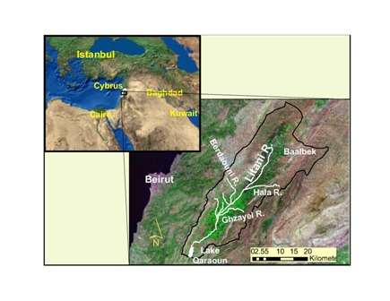
The Litani River Authority (LRA) was formed in 1954 to facilitate the integrated development of the Litani River Basin. Shortly after its formation, the LRA engaged in a massive hydroelectric development project that tapped the 850 meter head potential between Lake Qaraoun and the Mediterranean. This development has brought about major hydrological changes to the Litani River Basin, where the flows from its upper reaches above Lake Qaraoun, referred to as the Upper Litani Basin (ULB), are diverted through a system of tunnels, ponds and plants, to meet the Mediterranean several kilometers north of its original natural tailwater. These changes have resulted in the effective hydrological separation between the ULB and the Litani lower reaches.The advent of a protracted civil strife in the 1970s followed by a prolonged occupation in the 1980s that lasted into the 1990s, have plunged the country into disarray, freezing development and investment in infrastructure. The subsequent return to normal conditions has encouraged the LRA to initiate several major water diversion projects from the ULB worth hundreds of millions of US dollars.
Notes
References
- Ramadan, H.H., Beighley, R.E and Ramamurthy, A.S. (2013). "Temperature and precipitation trends in Lebanon’s largest river: the Litani Basin”, American Society of Civil Engineers, Journal of Water Resources Planning and Management, 139 (1), pp. 86–95.
- Ramadan, H.H., Ramamurthy, A.S., and Beighley, R.E (2012). "Inter-annual temperature and precipitation variations over the Litani Basin in response to atmospheric circulation patterns”, Theoretical and Applied Climatology, Volume 108, Numbers 3-4 (2012), pp. 563–577.
- Ramadan, H.H., Beighley R.E. and Ramamurthy A.S. (2012). "Modeling Streamflow Trends for a Watershed with Limited Data: A case on the Litani Basin, Lebanon” Hydrological Sciences Journal, 57 (8), pp. 1516–1529.
- Ramadan, H.H., Ramamurthy A.S. and Beighley R.E. (2013). "Sensitivity of the Litani Basin’s runoff in Lebanon to climate change.” International Journal of Environment and Pollution (in press).
- Bregman, Ahron (2002). Israel's Wars: A History Since 1947. London: Routledge. ISBN 0-415-28716-2
- Raad, Daoud, 2004. "Localized irrigation in Qasmieh-Ras-el-Aïn: a technique to be encouraged" pdf file
- Amery, H. A. 1993. "The Litani River of Lebanon", Geographical Review 83 (3) pp229–237.
- Where the western Litani empties into the Mediterranean, on Wikimapia
- Old Feud Over Lebanese River Takes New Turn
- Assaf, Hamed and Saadeh, Mark. "Development of an Integrated Decision Support System for Water Quality Control in the Upper Litani Basin, Lebanon", Proceedings of the iEMSs Third Biennial Meeting, "Summit on Environmental Modelling and Software". International Environmental Modelling and Software Society, Burlington, USA, July 2006.
See also
Coordinates: 33°20′20″N 35°14′43″E / 33.33889°N 35.24528°E