Little Snake River
| Little Snake River[1] | |
|---|---|
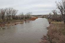 The river as it passes under Wyoming Highway 70 near Dixon. | |
| Basin | |
| Main source |
Confluence of Middle Fork and North Fork 7,001 ft (2,134 m) 40°59′36″N 107°02′51″W / 40.99333°N 107.04750°W[1]) |
| River mouth |
Confluence with Yampa River 5,620 ft (1,710 m) 40°27′09″N 108°26′32″W / 40.45250°N 108.44222°WCoordinates: 40°27′09″N 108°26′32″W / 40.45250°N 108.44222°W |
| Progression | Yampa—Green—Colorado |
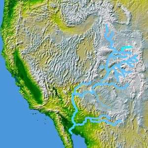
The Little Snake River, a tributary of the Yampa River, is shown highlighted on a map of the western United States
The Little Snake River is a tributary of the Yampa River, approximately 155 miles (249 km) long, in southwestern Wyoming and northwestern Colorado in the United States.
It rises near the continental divide, in Routt National Forest in northern Routt County, Colorado, along the northern edge of the Park Range. It flows west along the Wyoming-Colorado state line, meandering across the border several times and flowing past the Wyoming towns of Dixon and Baggs. It turns southwest and flows through Moffat County, Colorado, joining the Yampa approximately 45 mi (72 km) west of Craig, just east of Dinosaur National Monument. The Little Snake is not generally navigable except seasonally in years of plentiful water.
See also
- List of rivers of Colorado
- List of rivers of Wyoming
- List of tributaries of the Colorado River
- George R. Salisbury, Jr.
References
- 1 2 "Little Snake River". Geographic Names Information System. United States Geological Survey. Retrieved 2011-01-27.
This article is issued from Wikipedia - version of the 9/11/2016. The text is available under the Creative Commons Attribution/Share Alike but additional terms may apply for the media files.