Livermore Municipal Airport
| Livermore Municipal Airport | |||||||||||||||
|---|---|---|---|---|---|---|---|---|---|---|---|---|---|---|---|
 | |||||||||||||||
| IATA: LVK – ICAO: KLVK | |||||||||||||||
| Summary | |||||||||||||||
| Airport type | Public | ||||||||||||||
| Operator | City of Livermore | ||||||||||||||
| Location | Livermore, California | ||||||||||||||
| Elevation AMSL | 400 ft / 122 m | ||||||||||||||
| Coordinates | 37°41′36.2″N 121°49′13.3″W / 37.693389°N 121.820361°WCoordinates: 37°41′36.2″N 121°49′13.3″W / 37.693389°N 121.820361°W | ||||||||||||||
| Map | |||||||||||||||
 LVK Location of airport in California | |||||||||||||||
| Runways | |||||||||||||||
| |||||||||||||||
Livermore Municipal Airport (IATA: LVK, ICAO: KLVK) is in Livermore, California, United States, east of San Francisco Bay. It is classified by the FAA as a Regional Relief Airport.[1]
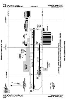
The airport is 3 miles (4.8 kilometres) northwest of the downtown area. Near the 650-acre (260-hectare) airport are the Water Reclamation Plant and the Las Positas Golf Course. There are two parallel asphalt runways. The main lighted runway is 5,250 ft (1,600 m) long. The second runway, unlighted, built in 1985, is 2,700 ft (820 m) long and is used mainly for training.[2] Besides the 2,400-square-foot (220 m2) terminal building, built in 1969, there are nearly 400 aircraft storage hangar units, a corporate-style hangar building containing 20,000 square feet (1,900 m2) of space and an aircraft storage shelter. 467 aircraft are based at Livermore Airport.
See also
References
- ↑ "2015–2019 NPIAS Report, Appendix A" (PDF, 7.89 MB). Federal Aviation Administration. January 20, 2015.
- ↑ History of the Livermore Airport