Liverpool Beach
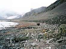
Liverpool Beach (Bulgarian: Ливърпулски бряг, ‘Livarpulski Bryag’ \'li-v&r-pul-ski 'bryag\) is the crescent-shaped beach extending 1.8 km on the east side of Walker Bay on the south coast of Livingston Island in the South Shetland Islands, Antarctica. It is situated on the west side of the small ice-free promontory ending in Hannah Point, and bounded by Hannah Point to the west, Ustra Peak to the northeast and the terminus of Verila Glacier to the north. The picturesque beach is one of the most popular tourist sites in Antarctica, frequented by cruise ships.
The beach is named after the British city of Liverpool, the home port of many 19th century sealing ships operating in the South Shetlands including the sealer Hannah after which the adjacent point is named.
Location
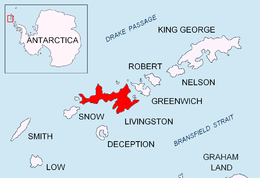
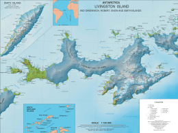
Liverpool Beach is located at 62°38′55″S 60°36′00″W / 62.64861°S 60.60000°WCoordinates: 62°38′55″S 60°36′00″W / 62.64861°S 60.60000°W. British mapping in 1821, 1962 and 1968, Argentine in 1959 and 1980, Chilean in 1971, Spanish in 1991, and Bulgarian in 2005 and 2009.
Maps
- L.L. Ivanov. Antarctica: Livingston Island and Greenwich, Robert, Snow and Smith Islands. Scale 1:120000 topographic map. Troyan: Manfred Wörner Foundation, 2010. ISBN 978-954-92032-9-5 (First edition 2009. ISBN 978-954-92032-6-4)
References
This article includes information from the Antarctic Place-names Commission of Bulgaria which is used with permission.