Loch Dornal
| Loch Dornal | |
|---|---|
 | |
| Location | Strathclyde, Scotland |
| Coordinates | 55°03′02″N 4°40′29″W / 55.05056°N 4.67472°WCoordinates: 55°03′02″N 4°40′29″W / 55.05056°N 4.67472°W |
| Type | freshwater loch |
| Primary inflows | Corwar burn |
| Primary outflows | Carrick burn |
| Basin countries | Scotland |
| Max. length | 0.66 mi (1.06 km)[1] |
| Max. width | 0.33 mi (0.53 km)[1] |
| Surface area | 43.8 ha (108 acres)[2] |
| Average depth | 5 ft (1.5 m)[1] |
| Max. depth | 10 ft (3.0 m)[1] |
| Water volume | 26,000,000 cu ft (740,000 m3)[1] |
| Shore length1 | 4.9 km (3.0 mi)[2] |
| Surface elevation | 118 m (387 ft)[2] |
| Islands | several islets [2] |
| 1 Shore length is not a well-defined measure. | |
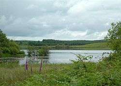
Loch Dornal is an irregular shaped, shallow, freshwater loch in Strathclyde, in the Southern Uplands of south-west Scotland. It lies approximately 8 mi (13 km) northwest of the town of Newton Stewart.[1]
There are several islets in the loch some of which contain archaeological features.[3]
The loch is stocked with rainbow trout and fishing is permitted with permission from Drumlamford Estate.[4]
Survey
The loch was surveyed[1] in 1903 by James Murray and later charted [5] as part of Sir John Murray's Bathymetrical Survey of Fresh-Water Lochs of Scotland 1897-1909.
References
- 1 2 3 4 5 6 7 "Bathymetrical Survey of the Fresh-Water Lochs of Scotland, 1897-1909, Lochs of the Cree Basin". National Library of Scotland. National Library of Scotland. Retrieved 13 September 2015.
- 1 2 3 4 "Loch Dornal". British lakes. British Lakes. Retrieved 13 September 2015.
- ↑ "Loch Dornal". Canmore. Royal Commission on the Ancient and Historical Monuments of Scotland. Retrieved 16 September 2015.
- ↑ Bruce Sandison (15 February 2011). Rivers and Lochs of Scotland: The Angler's Complete Guide. Black & White Publishing Limited. pp. 933–. ISBN 978-1-84502-520-5.
- ↑ "Loch Dornal; Kirriereoch Loch; Loch Trool (Vol. 5, Plate 42) - Bathymetrical Survey, 1897-1909 - National Library of Scotland". National Library of Scotland. Retrieved 13 September 2015.
This article is issued from Wikipedia - version of the 10/15/2016. The text is available under the Creative Commons Attribution/Share Alike but additional terms may apply for the media files.